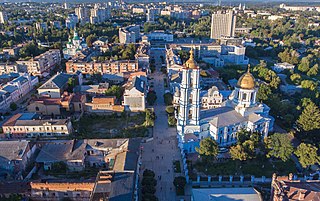
Sumy is a city in northeastern Ukraine. It serves as the administrative center of Sumy Oblast. The city is situated on the banks of the Psel River with a population of 256,474, making it the 23rd-largest in the country.

Sloboda Ukraine, also known locally as Slobozhanshchyna or Slobozhanshchina, is a historical region in northeastern Ukraine and southwestern Russia. It developed and flourished in the 17th and 18th centuries on the southwestern frontier of the Tsardom of Russia. In 1765, it was converted into the Sloboda Ukraine Governorate.

Sumy Oblast, also known as Sumshchyna (Сумщина), is an oblast (province) in northeast Ukraine. The oblast was created in its most recent form, from the merging of raions from Kharkiv Oblast, Chernihiv Oblast, and Poltava Oblast in 1939 by the Presidium of the Supreme Soviet of the Soviet Union.

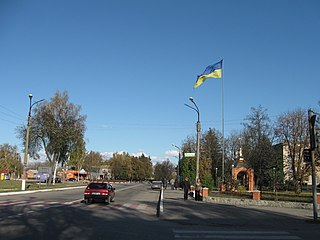
Okhtyrka is a city in Sumy Oblast, Ukraine. It serves as the administrative center of Okhtyrka Raion within the oblast. Okhtyrka was once home to Hussars and Cossacks. It was also in the past a regional seat of the Sloboda Ukraine Imperial Region and of the Ukrainian SSR. Since the discovery of oil and gas in 1961, Okhtyrka has come to be known as the "Oil Capital of Ukraine." It is home to the Okhtyrka air base and other historical and religious sites. Some religious buildings in Okhtyrka were almost destroyed in the Russian invasion of Ukraine.

Konotop is a city in Sumy Oblast, northeastern Ukraine. Konotop serves as the administrative center of Konotop Raion within the oblast. Konotop is located about 129 kilometres (80 mi) from Sumy, the administrative center of the oblast. It is host to Konotop Air Base. The population is 83,543.

Romny is a city in Sumy Oblast, northern Ukraine. It is located on the Romen River. Romny serves as the administrative centre of Romny Raion and hosts the administration of Romny urban hromada, one of the hromadas of Ukraine. Population: 37,765.

The Psel or Psyol is a river, a left tributary of the Dnieper, which flows through Russia and Ukraine.
Druzhba is a small city in the Shostka Raion of the Sumy Oblast, Ukraine. The population is 4,504.

Bilopillia is a city in Sumy Raion of Sumy Oblast of northeastern Ukraine. It was the administrative center of Bilopillia Raion until it was abolished on 18 July 2020. It is located close to Kursk Oblast of Russia. Population: 15,600. The city's ancient name is Vyr.
Nedryhailiv is a rural settlement situated on the Sula River in Sumy Oblast, northeastern Ukraine. It formerly served as the administrative center of the Nedryhailiv Raion, housing the raion's administrative structure until the raion's abolition in 2020, but is now administered within Romny Raion. Population: 5,252.
Korenevsky District is an administrative and municipal district (raion), one of the twenty-eight in Kursk Oblast, Russia. It is located in the southwest of the oblast. The area of the district is 873 square kilometers (337 sq mi). Its administrative center is the urban locality of Korenevo. Population: 15,018 (2021 Census); 18,294 (2010 Census); 21,474 ; 23,183 (1989 Soviet census). The population of Korenevo accounts for 37.0% of the district's total population.

Krasnopillia is a rural settlement in Sumy Oblast, Ukraine, located in the historic region of Sloboda Ukraine. It was formerly the administrative seat of Krasnopillia Raion, but is now within Sumy Raion. The settlement is 42 km (26 mi) away from Sumy, the regional center, and has a population of 7,769.

Tyotkino is an urban locality on the left bank of the Seym river in Glushkovsky District of Kursk Oblast, Russia. Population: 3,852 (2021 Census); 4,223 (2010 Census); 5,224 (2002 Census); 5,375 (1989 Soviet census).
Velyka Pysarivka is a rural settlement in Sumy Oblast, northeastern Ukraine. It was formerly the administrative center of Velyka Pysarivka Raion, but is now administered within Okhtyrka Raion. It is located close to the border with Russia, on the left bank of the Vorskla, a tributary of the Dnieper. Population: 3,928.
Uhroidy is a rural settlement in Sumy Raion, Sumy Oblast, Ukraine. It is located on the banks of the Rybytsia, a tributary of the Psel in the drainage basin of the Dnieper. Uhroidy belongs to Krasnopillia settlement hromada, one of the hromadas of Ukraine. Population: 1,837.
Khotin is a rural settlement in Sumy Raion, Sumy Oblast, Ukraine. It is located on the banks of the Oleshnia, a right tributary of the Psel in the drainage basin of the Dnieper. Khotin hosts the administration of Khotin settlement hromada, one of the hromadas of Ukraine. Population: 2,290.
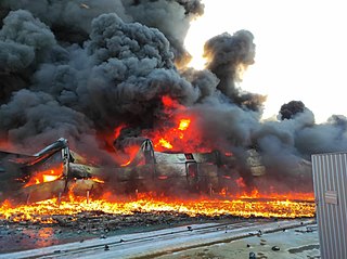
On 24 February 2022, the Russian army attempted to capture Sumy, located near the Russia–Ukraine border. Ukrainian paratroopers and territorial defense forces began engaging Russian forces within the city, resulting in heavy urban fighting and the destruction of a Russian tank column. That evening, Ukraine's paratroopers were ordered to withdraw from the city, leaving the city's defense to the a few thousand local volunteers armed with rifles, limited anti-tank weapons and no armed vehicles or heavy weaponry. After three to four days of failing to enter the city, the Russian military shifted to encircle and bypass the city, and were then subject to guerrilla ambushes.
A series of border skirmishes has taken place along the Russia–Ukraine border in Sumy and Chernihiv Oblasts since the withdrawal of Russian troops from northern Ukraine. Ukrainian officials have stated that strikes across the border happen daily.

Bilka, is a village in northern Ukraine, located in Okhtyrka Raion of Sumy Oblast.
Ryzhivka is a village in Sumy Raion (district) in Sumy Oblast of northeastern Ukraine, on the left bank of the Seim river, at some hundred meters of the Russia–Ukraine border. It belongs to Bilopillia urban hromada, one of the hromadas of Ukraine.


