Port Chalmers time ball

Last updated

The Port Chalmers time ball is a Victorian maritime Greenwich Mean Time signal located on Aurora Terrace on top of Observation Point in the port of Port Chalmers, New Zealand. It was established in 1867 by the Otago Provincial Council. The time ball fell precisely at 1 p.m. daily. Originally triggered by a grandfather clock, from 1882 onwards a telegraph signal from Wellington took over this function. It was removed in 1970, but a replacement was restored to service in 2020.

Contents

History

Following the introduction of New Zealand's first time ball, established at Wellington in March 1864, proposals were put forward for the introduction of a similar time signaling device at Port Chalmers. Originally it was suggested by harbourmaster W. Thomson that a time gun be used in preference to a time ball, as at noon, ship masters are frequently on shore, and were more likely to hear a gun than observe a time ball. The gun would also indicate the time to the inhabitants of the town, many of whom were not within sight of the signal station, and to the harbour ferry masters. [1] It was not until 1867, following pressure from shipowners, that the Otago Provincial Council decided to install a time ball on the existing flagstaff on top of Observation Point. The flagstaff which was installed in 1864 had formerly been the mizzen mast on the condemned barque "Cincinnati". This ship had once been owned by the notorious Bully Hayes.

Active preparations are being made for the working of the long needed time ball at the Flagstaff, Port Chalmers. A conductor has been laid from the Observatory to the Flagstaff, which being attached to the haulyards by a simple arrangement, the ball is dropped instantaneously by the signal master. The whole of the arrangements are expected to be completed in a week, when the great want of a time ball to the shipping community will be numbered with the things of the past.

Otago Daily Times, 30 March 1867 [2]

It was the first publicly funded time ball in New Zealand. [3]

The service started on Saturday 1 June 1867 with the ball being dropped daily, except Sundays, at 1 p.m. Port Chalmers time, that is, 1 hour 37 minutes 23.5 seconds a.m. Greenwich Mean Time. [4] Despite the introduction of New Zealand mean time in 1868 the stated drop time continued to be 1 p.m. Port Chalmers mean time. [4] The exact time was kept by a grandfather clock which was checked every day at 9 a.m. when a signal was telegraphed from Wellington to the signal master.

At 12.45 p.m. the time ball was hoisted on the flagstaff, while officers on the ships would stand by their chronometers and an apprentice would be outside watching the time ball. At 1 pm the signal master would drop the ball and the apprentice would shout "Stop". The officers would then check their chronometers (and no doubt local residents also checked their clocks and watches). The time was recorded when the ball began descending, not when it reached the bottom.

Regular notices such as the following appeared in the local newspapers to announce the operation of the time ball:

PORT CHALMERS OBSERVATORY.
Latitude, 45.48.55 south; longitude, 11 h. 22m. 36 sec. east.
Time ball drops daily (Sundays excepted), at 1 p.m., Port Chalmers mean time, or 1 h. 37m. 23secs. a.m. Greenwich mean time.

Otago Daily Times, 19 June 1867 [5]

The service was discontinued in October 1877, but following a petition to the Otago Harbour Board from 11 shipmasters in January 1881 [6] it was decided in March 1881 to reinstate it as a weekly service. [6]

The service resumed in April 1882, with the time received by a signal via the telegraph line from the Wellington Telegraph Office. The time ball was dropped at the instant the current moved the needle of a galvanometer. The time given was mean time at longitude 11h 30min 00.3 sec east. [4] Prior to the ball being dropped a blue flag was hoisted on the signal staff at about 10 a.m. The Otago Harbour Board took over operation of the time ball station in 1885 and service was dropped to twice a week. [3] In June 1910 it was necessary to replace the original flagstaff (which had rotted) with a new ironbark flagstaff. [3] By that same year the time ball had fallen into disrepair, and as fewer vessels were visiting port the need for its service was waning, so its original function was discontinued. [3] [4]

The ball continued to be used until 1931 to warn local fishermen of high seas off Taiaroa Head and of shipping coming down the Upper Otago Harbour from Dunedin. [7] It remained hung from the yardarm on the flagstaff for many years, but was removed in 1970 when the flagstaff was restored and moved to a new location 50-100 yards closer to Port Chalmers, but still on Observation Point. [7]

Reinstatement

In 2019 the Port Chalmers Historical Society agreed to support a proposal by a small group of its members to reinstate a time ball on the existing flagstaff. This group consisting of Garry Bain, Warner Gardiner, Norman Ledgerwood, and Harold Woods, raised $50,000 to install a replacement time ball.

The new 120 kg time ball made from marine-grade stainless steel and its operating mechanism were designed, manufactured, and installed by Stark Bros Ltd of Lyttelton. [7] The time ball was installed in August 2020. [7] Since it was officially opened on 3 October 2020 [8] the time ball has operated daily at 1 pm seven days a week.

The flagstaff is designated as a Category 2 Historic Place by Heritage New Zealand. [3]

The original clock that operated the time ball is housed in the collection of the Toitū Otago Settlers Museum in Dunedin. The only other operational time ball in New Zealand is at Lyttelton. [9]

See also

Related Research Articles

<span class="mw-page-title-main">Time signal</span> Signal used as a reference to determine the time of day

A time signal is a visible, audible, mechanical, or electronic signal used as a reference to determine the time of day.

<span class="mw-page-title-main">Otago Harbour</span> The natural harbour of Dunedin, New Zealand

Otago Harbour is the natural harbour of Dunedin, New Zealand, consisting of a long, much-indented stretch of generally navigable water separating the Otago Peninsula from the mainland. They join at its southwest end, 21 km (13 mi) from the harbour mouth. It is home to Dunedin's two port facilities, Port Chalmers and at Dunedin's wharf. The harbour has been of significant economic importance for approximately 700 years, as a sheltered harbour and fishery, then deep water port.

<span class="mw-page-title-main">Dunedin</span> City in Otago, New Zealand

Dunedin is the second-largest city in the South Island of New Zealand, and the principal city of the Otago region. Its name comes from Dùn Èideann, the Scottish Gaelic name for Edinburgh, the capital of Scotland. The city has a rich Scottish, Chinese and Māori heritage.

<span class="mw-page-title-main">Lyttelton, New Zealand</span> Place in Canterbury, New Zealand

Lyttelton is a port town on the north shore of Lyttelton Harbour / Whakaraupō, at the northwestern end of Banks Peninsula and close to Christchurch, on the eastern coast of the South Island of New Zealand.

<span class="mw-page-title-main">Time ball</span> Time-signalling device

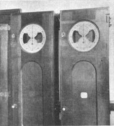
A time ball or timeball is a time-signalling device. It consists of a large, painted wooden or metal ball that is dropped at a predetermined time, principally to enable navigators aboard ships offshore to verify the setting of their marine chronometers. Accurate timekeeping is essential to the determination of longitude at sea.

<span class="mw-page-title-main">James Macandrew</span> New Zealand politician

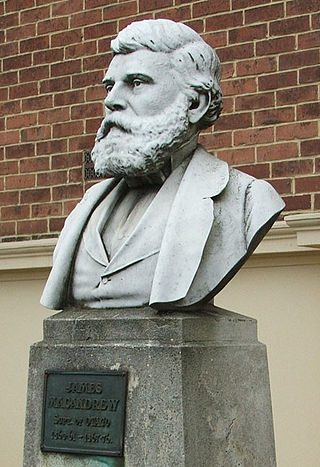
James Macandrew was a New Zealand ship-owner and politician. He served as a Member of Parliament from 1853 to 1887 and as the last Superintendent of Otago Province.

<span class="mw-page-title-main">Port Chalmers</span> Main seaport of Dunedin, New Zealand

Port Chalmers is a town serving as the main port of the city of Dunedin, New Zealand. Port Chalmers lies ten kilometres inside Otago Harbour, some 15 kilometres northeast of Dunedin's city centre.

<span class="mw-page-title-main">Hong Kong Time</span> Official time zone of Hong Kong

Hong Kong Time is the time in Hong Kong, observed at UTC+08:00 all year round. The Hong Kong Observatory is the official timekeeper of the Hong Kong Time. It is indicated as Asia/Hong_Kong in the IANA time zone database.

<span class="mw-page-title-main">Port Chalmers Branch</span>

The Port Chalmers Branch was the first railway line built in Otago, New Zealand, and linked the region's major city of Dunedin with the port in Port Chalmers. The line is still operational today.

<span class="mw-page-title-main">History of the Dunedin urban area</span> Aspect of history of city of Dunedin, New Zealand

The villages and then city that lay at the head of Otago Harbor never existed in isolation, but have always been a staging ground between inland Otago and the wider world. While Dunedin's current official city limits extend north to Waikouaiti, inland to Middlemarch and south to the Taieri River mouth, this articles focus is the history of the Dunedin urban area, only mentioning Mosgiel, the Otago Peninsula, Port Chalmers and inland Otago for context.

<span class="mw-page-title-main">Shepherd Gate Clock</span> Clock outside Greenwich Observatory, London

The Shepherd Gate Clock is mounted on the wall outside the gate of the Royal Observatory, Greenwich building in Greenwich, Greater London. The clock, an early example of an electrically connected clock system, was a sympathetic clock mechanism controlled by electric pulses transmitted by a motor clock inside the main building. The network of 'sympathetic clocks' was constructed and installed by Charles Shepherd in 1852. The clock by the gate was probably the first to display Greenwich Mean Time to the public, and is unusual in using the 24-hour analog dial. Also it originally showed astronomical time which started at 12 noon not midnight.

<span class="mw-page-title-main">Holy Trinity Church, Port Chalmers</span> Church in Port Chalmers, New Zealand

Holy Trinity Church is an Anglican church in Port Chalmers, New Zealand. The church building is constructed in volcanic stone and has some fine stained glass, and is listed as a Category I Historic Place. Together with St Barnabas Church, Warrington, Holy Trinity Church is part of the Port Chalmers-Warrington Parish of the Anglican Diocese of Dunedin, New Zealand.

<span class="mw-page-title-main">Public transport in Dunedin</span>

Public transport in Dunedin, New Zealand is mainly by bus. The Otago Regional Council designs routes and schedules and contracts operation of bus services to two bus companies, Go Bus Transport and Ritchies Transport. Services operate daily at mainly 15 to 30-minute headways; services on evenings, weekends and holidays at about half the weekday frequency and there are no services on late Sunday or holiday evenings, nor on Christmas Day, Good Friday or Easter Sunday.

<span class="mw-page-title-main">James Walker Bain</span> New Zealand politician

James Walker Bain was a 19th-century New Zealand politician. He was a significant businessman in Invercargill and Southland.

<span class="mw-page-title-main">Ravensbourne, New Zealand</span> Suburb of Dunedin, New Zealand

Ravensbourne is a suburb of the New Zealand city of Dunedin. It is located on Otago Harbour on the steep southeastern slopes of Signal Hill. It lies on the harbour's northern shore, 4.5 kilometres (2.8 mi) east-northeast of the city centre.

Chalmers, originally Port Chalmers, was a parliamentary electorate in the Otago Region of New Zealand, from 1866 to 1938 with a break from 1896 to 1902. It was named after the town of Port Chalmers, the main port of Dunedin and Otago.

State Highway 88 (SH 88) is a New Zealand State Highway connecting the city centre of Dunedin with Port Chalmers, which is the location of Dunedin's main port facilities and home of one of New Zealand's major container terminals. It is roughly 12 km long.

Philip Laing is a 19th-century sailing ship best known as the second immigrant ship to arrive in Dunedin, New Zealand, on 15 April 1848. Chartered by the New Zealand Company for this voyage the ship was carrying Scottish settlers, under the charge of the Rev. Dr. Thomas Burns.

Matoaka was a 1092-ton wooden New Brunswick full-rigged ship built in 1853 for Willis, Gunn, & Co. She was sold to Shaw, Savill, & Albion by 1859. Between 1859 and 1869 she made eight voyages to New Zealand. Her fastest run from Bristol to Lyttelton, New Zealand was 82 days in 1862. On 13 May 1869 she left Lyttelton for London under Captain Alfred Stevens with 45 passengers and 32 crew but was never seen again. In 1865 she was classed as 1322 tons.

<span class="mw-page-title-main">Observation Point</span>

Observation Point, also known as Flagstaff Lookout or Flagstaff Hill, and formerly as Flagstaff Point is a large bluff in central Port Chalmers, in New Zealand's South Island. The point, as its name suggests, offers panoramic views covering the town, its deep-water port, and across the Otago Harbour. A road, Aurora Terrace, ascends to near the top of the point, allowing for easy public access.

References

  1. "Harbor Department. No. III", Otago Daily Times, 9 April 1864, retrieved 30 January 2021
  2. "Shipping", Otago Daily Times, 30 March 1867, retrieved 30 January 2021
  3. 1 2 3 4 5 "Flagstaff". Register of Historic Places. Heritage New Zealand.
  4. 1 2 3 4 Kinns, Roger (2017). "The Principal Time Balls of New Zealand". Journal of Astronomical History and Heritage. 20 (1): 81–84.
  5. "Shipping", Otago Daily Times, 19 June 1872, retrieved 30 January 2021
  6. 1 2 "Harbor Board", Evening Star, 28 January 1881, retrieved 30 January 2021
  7. 1 2 3 4 MacLean, Hamish (21 August 2020). "Historic timeball refitted above port". Otago Daily Times. Retrieved 30 January 2021.
  8. Lewis, John (5 October 2020), "Time ball testing tenterhooks take hold", Otago Daily Times, retrieved 30 January 2021
  9. Morris, Chris (27 November 2019), "$60,000 to reinstate historic Port Chalmers timeball", Otago Daily Times, retrieved 30 January 2021

Coordinates: 45°48′55″S170°37′35″E / 45.81528°S 170.62639°E / -45.81528; 170.62639