Westmoreland County is a county located in the Northern Neck of the Commonwealth of Virginia. As of the 2020 census, the population sits at 18,477. Its county seat is Montross.

King George County is a county located in the Commonwealth of Virginia. As of the 2020 census, the population sits at 26,723. Its county seat is the town of King George.

Caroline County is a United States county located in the eastern part of the Commonwealth of Virginia. The northern boundary of the county borders on the Rappahannock River, notably at the historic town of Port Royal. The Caroline county seat is Bowling Green.
Port Royal is an incorporated town in Caroline County, Virginia, United States. The population was 126 at the 2010 census.

Warsaw is an incorporated town in and the county seat of Richmond County, Virginia, United States. The population was 1,637 at the 2020 census and is estimated to be 2,281 as of 2022.

Falmouth is a census-designated place (CDP) in Stafford County, Virginia, United States. Situated on the north bank of the Rappahannock River at the falls, the community is north of and opposite the city of Fredericksburg. Recognized by the U.S. Census Bureau as a census-designated place (CDP), Falmouth's population was 4,274 as of the 2010 census.

Montross is a town in Westmoreland County, Virginia, United States. The population was 553 at the 2020 census. It is the county seat of Westmoreland County. Located in the historic Northern Neck of Virginia, Montross is near the George Washington Birthplace National Monument and the Stratford Hall Plantation. The town's slogan is return to the village.

The Northern Neck is the northernmost of three peninsulas on the western shore of the Chesapeake Bay in the Commonwealth of Virginia. The Potomac River forms the northern boundary of the peninsula; the Rappahannock River demarcates it on the south. The land between these rivers was formed into Northumberland County in 1648, prior to the creation of Westmoreland County and Lancaster County. The Northern Neck encompasses the following Virginia counties: Lancaster, Northumberland, Richmond, King George and Westmoreland; it had a total population of 50,158 as of the 2020 census.

The Rappahannock River is a river in eastern Virginia, in the United States, approximately 195 miles (314 km) in length. It traverses the entire northern part of the state, from the Blue Ridge Mountains in the west where it rises, across the Piedmont to the Fall Line, and onward through the coastal plain to flow into the Chesapeake Bay, south of the Potomac River.

Amissville is an unincorporated community in Rappahannock County in the U.S. commonwealth of Virginia. It is located on U.S. Route 211 about halfway between Warrenton and the small town of Washington, Virginia.

Everton Judson Conger was an American officer during the Civil War who was instrumental in the capture of John Wilkes Booth, the assassin of President Abraham Lincoln, in a Virginia barn twelve days after Lincoln was shot.

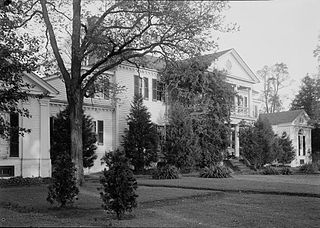
Woodlawn is a historic house located in Fairfax County, Virginia. Originally a part of Mount Vernon, George Washington's historic plantation estate, it was subdivided in the 19th century by abolitionists to demonstrate the viability of a free labor system. The address is now 9000 Richmond Highway, Alexandria, Virginia, but due to expansion of Fort Belvoir and reconstruction of historic Route 1, access is via Woodlawn Road slightly south of Jeff Todd Way/State Route 235. The house is a designated National Historic Landmark, primarily for its association with the Washington family, but also for the role it played in the historic preservation movement. It is now a museum property owned and managed by the National Trust for Historic Preservation.

Belle Isle State Park is located in Lancaster County, Virginia, on the Rappahannock River. It sits between Deep Creek and Morattico Creek and is currently under public ownership. The park has an area of 892 acres (3.61 km2) and has facilities for camping, fishing, boating and picnics. As of 2015, the yearly visitation was 44,502.

Cedar Creek and Belle Grove National Historical Park became the 388th unit of the United States National Park Service when it was authorized on December 19, 2002. The National Historical Park was created to protect several historically significant locations in the Shenandoah Valley of Northern Virginia, notably the site of the American Civil War Battle of Cedar Creek and the Belle Grove Plantation.

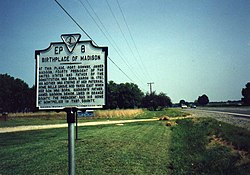
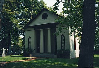
Emmanuel Episcopal Church is an historic Episcopal church located on the west side of U.S. Route 301, just north of the Rappahannock River in Port Conway, Virginia, in the United States. Emmanuel Church and its historic graveyard are located in front of Belle Grove. In 1751, future President James Madison was born at Belle Grove, the childhood home of his mother, Eleanor Rose "Nelly" Conway. On January 7, 1987, Emmanuel Church was added to the National Register of Historic Places.
Belle Grove is a historic plantation located on U.S. Route 301 in Port Conway, Virginia. The present plantation house was built in 1790.

Oak Grove is an unincorporated community in the Washington District of Westmoreland County, Virginia. The community, on the historic Northern Neck of Virginia, was a stagecoach stop in the early days of the Colony of Virginia

Ottoman is an unincorporated community in Lancaster County located on the Northern Neck of the Rappahannock River in the U.S. state of Virginia.
The Nanzatico (Nantaughtacund) community was a group of Native Americans that included remnants of earlier tribes displaced by English settlers in and around King George County, Virginia. The group was made up of Portobagos from Maryland, Patawomecks from the Northern Neck area, Matchotics, and Rappahannock tribe members along with others. The original Nantaughtacund were noted by that name living on the Rappahannock River by John Smith on 1608, represented on his map as a "king's house".

The Woodlawn Historic and Archeological District encompasses a historic plantation near the Rappahannock River in southern King George County, Virginia. The 899-acre (364 ha) property is located east of US Route 301 near Port Conway. The estate boundaries are essentially the same as those when the plantation was first established in 1790. The main plantation house dates to that time although it has been extended and altered over the intervening centuries. Also of notable interest on this property are surviving antebellum slave quarters, and archaeological sites containing evidence of Native American occupation of the land.