Transport in Guinea is composed by a variety of systems that people in the country use to get around as well as to and from domestic and international destinations. The railway from Conakry to Kankan ceased operating in the mid-1980s. Most vehicles in Guinea are 20+ years old, and cabs are any four-door vehicle which the owner has designated as being for hire. Domestic air services are intermittent. Conakry International Airport is the largest airport in the country, with flights to other cities in Africa as well as to Europe.
The region now known as Guinea-Bissau has been inhabited for thousands of years. In the 13th century, it became a province of the Mali Empire that later became independent as the Empire of Kaabu. The region was claimed by Portugal beginning in the 1450s. During most of this period, Portuguese control of the region was limited to a number of forts along the coast. Portugal gained full control of the mainland after the pacification campaigns of 1912–15. The offshore Bijago islands were not colonised until 1936. After independence in 1974, the country was controlled by a single-party system until 1991. The introduction of multi-party politics in 1991, brought the first multi-party elections in 1994. A civil war broke out from 1998 to 1999.

The economy of Guinea-Bissau comprises a mixture of state-owned and private companies. Guinea-Bissau is among the world's least developed nations and one of the 10 poorest countries in the world, and depends mainly on agriculture and fishing. Cashew crops have increased remarkably in recent years, and the country ranked ninth in cashew production for the year 2019.

The recorded history of Cape Verde begins with the Portuguese discovery of the island in 1458. Possible early references to Cape Verde date back at least 2,000 years.

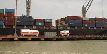
Bissau is the capital and largest city of Guinea-Bissau. As of 2015, it had a population of 492,004. Bissau is located on the Geba River estuary, off the Atlantic Ocean, and is Guinea-Bissau's largest city, major port, its administrative and military center.

A pier is a raised structure that rises above a body of water and usually juts out from its shore, typically supported by piles or pillars, and provides above-water access to offshore areas. Frequent pier uses include fishing, boat docking and access for both passengers and cargo, and oceanside recreation. Bridges, buildings, and walkways may all be supported by architectural piers. Their open structure allows tides and currents to flow relatively unhindered, whereas the more solid foundations of a quay or the closely spaced piles of a wharf can act as a breakwater, and are consequently more liable to silting. Piers can range in size and complexity from a simple lightweight wooden structure to major structures extended over 1,600 m (5,200 ft). In American English, a pier may be synonymous with a dock.

A jetty is a structure that projects from land out into water. A jetty may serve as a breakwater, as a walkway, or both; or, in pairs, as a means of constricting a channel. The term derives from the French word jetée, "thrown", signifying something thrown out.
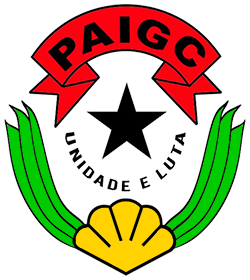
The African Party for the Independence of Guinea and Cape Verde is a political party in Guinea-Bissau. Originally formed to peacefully campaign for independence from Portugal, the party turned to armed conflict in the 1960s and was one of the belligerents in the Guinea-Bissau War of Independence. Towards the end of the war, the party established a socialist one-party state, which remained intact until multi-party democracy was introduced in the early 1990s. Although the party won the first multi-party elections in 1994, it was removed from power in the 1999–2000 elections. However, it returned to office after winning parliamentary elections in 2004 and presidential elections in 2005, since which it has remained the largest party in the National People's Assembly.
Oio is a region in Guinea-Bissau. Its capital is Farim. Other major cities and towns include Nhacra, Mansôa, Bissorã and Cumeré. The region borders Senegal to the north, the Guinea-Bissau regions of Bafatá, Bissau and Biombo to the east, the Rio Geba/Guinea-Bissau region of Quinara to the south and the Guinea-Bissau region of Cacheu to the west. There has not been any local administration since the civil war of 1998-99 and all the social services are done by organs of civil society and other government agencies. It is a coastal region covered with Mangrove swamps, rain forest and tangled forest and receives an annual rainfall of more than 1,000 mm (39 in), while the inland has savannah woodlands.

The Corubal, also known as the Rio Corubal or Tomine, is a river of West Africa, a major tributary of the Geba River. For a short distance, it forms the international border between Guinea and Guinea-Bissau. It has a length of approximately 560 kilometres (350 mi).

Chennai Port, formerly known as Madras Port, is the second largest container port of India, behind Mumbai's Nhava Sheva. The port is the largest one in the Bay of Bengal. It is the third-oldest port among the 13 major ports of India with official port operations beginning in 1881, although maritime trade started much earlier in 1639 on the undeveloped shore. It is an artificial and all-weather port with wet docks. Once a major travel port, it became a major container port in the post-Independence era. An established port of trade of British India since the 1600s, the port remains a primary reason for the economic growth of Tamil Nadu, especially for the manufacturing boom in South India, and has contributed greatly to the development of the city of Chennai. It is due to the existence of the port that the city of Chennai eventually became known as the Gateway of South India.
The Pidjiguiti massacre was an incident that took place on 3 August 1959 at the Port of Bissau's Pijiguiti docks in Bissau, Portuguese Guinea. Dock workers went on strike, seeking higher pay, but a manager called the PIDE, the Portuguese state police, who fired into the crowd, killing at least 25 people. The government blamed the revolutionary group African Party for the Independence of Guinea and Cape Verde (PAIGC), arresting several of its members. The incident caused PAIGC to abandon their campaign of nonviolent resistance, leading to the Guinea-Bissau War of Independence in 1963.

Mumbai Port Trust is a port which lies midway on the West coast of India, on the natural deep-water harbour of Mumbai (Bombay) in Maharashtra.The harbour spread over 400 square kilometres (150 sq mi) is protected by the mainland of Konkan to its east and north and by the island city of Mumbai to its west. The harbour opens to the south to the Arabian Sea.
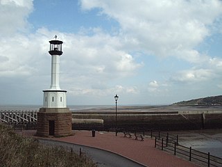
Maryport Lighthouse is a small lighthouse located in Maryport, Cumbria, England, formerly run by England's general lighthouse authority, Trinity House. It is a Grade II listed building.
The Two Faces of War is a 2007 Portuguese documentary film directed by Diana Andringa and Flora Gomes. The film was shot in Guinea-Bissau, Cape Verde and Portugal. The film includes a series of interviews and testimonies of people who lived through the period of the anti-colonial war and liberation in Guinea-Bissau.

The Port of Immingham, also known as Immingham Dock, is a major port on the east coast of England, located on the south bank of the Humber Estuary in the town of Immingham, Lincolnshire. In 2019, the Port of Grimsby & Immingham was the largest port in the United Kingdom by tonnage with 54.1 million tonnes of cargo passing through that year.
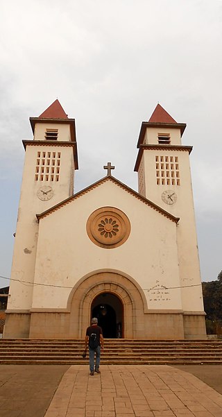
Bissau Cathedral, also known as Sé Catedral de Nossa Senhora da Candelária is a Catholic cathedral in Bissau, Guinea-Bissau. It is the centre of the Catholic Church in Guinea-Bissau. The cathedral is the seat of Diocese of Bissau, which was created in 1977. Situated in the downtown area of Bissau, it is noted for its function as a lighthouse. Services are held in Portuguese language.

North Killingholme Haven is a water outlet on the south bank of the Humber Estuary in the civil parish of North Killingholme, to the north-west of the Port of Immingham.
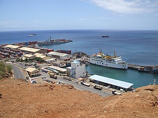
Praia Harbor is the port of the city of Praia in the southern part of the island of Santiago, Cape Verde. It is situated in a natural bay of the Atlantic Ocean. Since the latest modernization in 2014, it has 2 long quays, 3 shorter quays, a quay for fishing boats with fish processing installations, 2 container parks, 2 roll-on/roll-off ramps and a passenger terminal. The total length of the quays is 863 m, and the maximum depth is 13.5 m. The port of Praia played an important role in the colonization of Africa and South America by the Portuguese. With 817,845 metric tonnes of cargo and 85,518 passengers handled (2017), it is the second busiest port of Cape Verde, after Porto Grande (Mindelo).
Bissau is a city in Guinea-Bissau, a country in West Africa, formerly part of the kingdom of Kaabu and part of the Mali Empire.