Portreath Tramroad

Last updated

View of Portreath Harbour; the tramroad approached from the right centre of the picture, between the two rows of white-faced houses 23 Portreath.JPG
View of Portreath Harbour; the tramroad approached from the right centre of the picture, between the two rows of white-faced houses

The Portreath Tramroad, or alternatively the Portreath Tramway, was opened in 1815, providing a wagonway route from mines near Scorrier in Cornwall, England, to a port at Portreath. From there, it could be transported to market by coastal shipping. It was later extended to serve the Poldice mine near St Day and became known as the Poldice Tramroad, or Poldice Tramway.

Contents

It was a horse-drawn plateway and was the first railway in the county of Cornwall, starting operation in 1809.

As a technological pioneer, it soon became technically obsolescent but continued in use until about 1865. Much of the route can be discerned today, and parts can be walked or cycled.

History

Early technology

From the sixteenth century, minerals—chiefly copper—had been extracted southeast of Scorrier in Cornwall, England. The smelting of copper ore required about ten times its weight in coal, and the practice was to transport the ore to a location where there was a ready coal supply and carry out the smelting there. In the 18th century the Cornish ore was mainly taken to Swansea, earning it the nickname Copperopolis. A small harbour was built at Portreath sometime between 1713 and 1753. [1] The ore was exported, and coal and timber were brought in to serve the mining activity and the lime kilns. In 1824, the harbour was further improved.

The heavy materials were conveyed the few miles between the mines and the port by pack horse or mule, an expensive and time-consuming means of transport. Seeking an improved means of transport, in 1798 (Francis Basset), "Paid Mr. John Williams subscription towards planning a canal from Portreath £10. 10s. 0d". [2]

The canal was not proceeded with: water supply may have been a problem. In the immediately following years, alternative technologies were being developed. Richard Trevithick had demonstrated his steam road carriage, the Puffing Devil, at Camborne in 1801. [3] The following year, he constructed a practical steam hammer at the Penydarren Ironworks and converted it into a self-propelled locomotive. In a demonstration, it successfully hauled a load of ten tons over 10 miles (16 km). [1]

A tramroad for Portreath

Map of the Portreath Tramroad Poldice map.gif
Map of the Portreath Tramroad

These developments encouraged Basset and Williams to collaborate in projecting a tramroad, and The Portreath Tram Road Company was created by them and their partners, with a capital of £20,000. The first "rail" was laid by Bassett on 25 October 1809. The line was a wagonway, in which cast iron plates of L-shaped cross-section were laid on stone blocks. Wagons with plain wheels ran on the flat of the L and were guided by the upstand; horses pulled the wagons, walking between the plates.

R. Hansford Worth quotes Mr Francis Mitchell, C.E., of Redruth, in saying (in 1888) that "The line has been taken up, and that it consisted of two angle irons, placed face to face, and not back to back as was usual [on later lines]... These irons were fastened to stone blocks, and the gauge was about 3 ft." [3]

Mitchell may have mistaken the track gauge: three feet is remarkably narrow for a non-mountain tramroad; Otter (page 9) gives 4 ft, as does Fairclough (page 7); Symons, Barton, and Thomas are silent on the matter; Baxter (page 208) says "3 ft 0 in gauge (possibly)".

This was the first railway in Cornwall, but as it was a plateway, some claim that the later Redruth and Chasewater Railway was the first true railway in the county.

The Company (or its proprietors) also owned the harbour, and the use of the tramroad and the harbour was exclusive to them. Initially, it was laid as far as North Downs, near Scorrier, and a storage yard was built there. There was a branch to Treskerby, serving the mine there and Wheal Chance. [3] [4] [5]

This first portion of the line was in use by 1812. Between 1815 and 1819, it was extended to Crofthandy, serving Poldice, Wheal Unity, and Wheal Gorland mines. [4] Including the branch to Treskerby, the line cost about £20,000. There was no provision for passengers. [5]

A monopoly—at first

The track of the Portreath Tramroad near Bridge, Cornwall 27 Poldice - Bridge.JPG
The track of the Portreath Tramroad near Bridge, Cornwall

The proprietors of Portreath Harbour, and the tramroad, permitted only their mines to use those facilities, and for some years, this gave them an enormous competitive advantage. The mines were at their most productive, and the facility of conveying minerals cheaply to the harbour was extremely valuable. Mines "such as Poldice, Wheal Unity, Wheal Gorland, Carharrack and Wheal Maid probably sent ores over the Portreath tram-road, but all the others would ship almost entirely from Devoran." [6]

Rival mine owners were placed at a huge disadvantage, and this led to the development of Devoran Harbour on the south coast of Cornwall and the promotion of the Redruth and Chasewater Railway to reach it; that railway opened in 1825. In time the mining areas served by the tramroad and the railway were closely associated, but Devoran had the disadvantage of being on the English Channel side of Cornwall, so the crossing to Swansea involved a longer and sometimes hazardous passage around Land's End.

The Hayle Railway opened a standard gauge railway to Portreath in 1837, and in 1855 the Redruth and Chasewater Railway introduced steam locomotives. A local correspondent to the Mining Journal in 1855 described the Portreath Tramroad as "altogether a wretched road." [note 1] [7]

Decline of mining activity

The track of the Portreath Tramroad near St Day 28 Poldice.JPG
The track of the Portreath Tramroad near St Day

The tramroad was entirely dependent on the activity of the mines it served. In the 1860s, large, easily worked deposits of the minerals started to be extracted in Spain and elsewhere, and the Cornish mines became uneconomic to operate. The tramroad was little used by 1865 and was closed completely soon after, the tramplates being taken up and sold for scrap around 1882. [5]

Much of the route is now a bridleway, forming part of the Cornish Mineral Tramway Trails route for walkers, cyclists, and horse-riders.

1884 description

Symons described the line in retrospect, writing in 1884:

The first tramway laid down in Cornwall, is that connecting Portreath with Poldice mine, near St Day. Its construction was started about the year 1809, when most of the Gwennap mines were in full operation; as was also North Downs in Redruth. It was much in use till the stoppage of Poldice and the adjacent mines about 20 years ago. At present, [it] is not very much wanted, and [it] is in a very dilapidated state. In 1830 the writer rode in a car to a Portreath tea party, of which party he is the only survivor. [8]

Directors' wagon

Tramroad director's wagon Portreath Tramroad carriage.JPG
Tramroad director's wagon

A small wagon fitted with two bench seats has survived. It is believed to have been used to carry the tramroad's directors. [9]

Further reading

Notes

  1. This quote is in a footnote in Barton, page 47, referencing the Mining Journal in 1855, but the original quotation cannot be found there.

See also

Related Research Articles

<span class="mw-page-title-main">Carharrack</span> Village and civil parish in Cornwall, England

Carharrack is a civil parish and village in west Cornwall, England, United Kingdom. It is situated two miles (3 km) east of Redruth in a former mining area.

<span class="mw-page-title-main">Chacewater</span> Human settlement in England

Chacewater is a village and civil parish in Cornwall, England, UK. It is situated approximately 3 miles (4.8 km) east of Redruth. The hamlets of Carnhot, Cox Hill, Creegbrawse, Hale Mills, Jolly's Bottom, Salem, Saveock, Scorrier, Todpool, Twelveheads and Wheal Busy are in the parish. The electoral ward is called Chacewater & Kenwyn. At the 2011 census a population of 3,870 was quoted.

<span class="mw-page-title-main">Porthtowan</span> Human settlement in England

Porthtowan is a small village in Cornwall, England which is a popular summer tourist destination. Porthtowan is on Cornwall's north Atlantic coast about 2 km (1.2 mi) west of St Agnes, 4 km (2.5 mi) north of Redruth, 10 km (6.2 mi) west of Truro and 15 km (9.3 mi) southwest of Newquay in the Cornwall and West Devon Mining Landscape, a World Heritage Site.

<span class="mw-page-title-main">Poldice mine</span> Former metalliferous mine in southwest Cornwall, England

Poldice mine is a former metalliferous mine located in Poldice Valley in southwest Cornwall, England, United Kingdom. It is situated near the hamlet of Todpool, between the villages of Twelveheads and St Day, three miles (5 km) east of Redruth. Since the early 2000’s the area has been adopted by the local mountain biking community known as the Dice Rollers. The area is now nationally famous as the best location to ride MTB in the south west attracting attention from youtube superstars such as Ben Deakin and his friend Matt Edgie. This is a popular location for mountain bicycling

<span class="mw-page-title-main">Portreath</span> Human settlement in England

Portreath is a civil parish, village and fishing port on the north coast of Cornwall, England, United Kingdom. The village is about three miles (5 km) west-north-west of Redruth. The village extends along both sides of a stream valley and is centred on the harbour and beach. West of the harbour entrance and breakwater are two sandy beaches that are popular with holidaymakers, surfers and naturists.

<span class="mw-page-title-main">Gwennap</span> Village and civil parish in Cornwall, England

Gwennap is a village and civil parish in Cornwall, England, United Kingdom. It is about five miles (8 km) southeast of Redruth. Hamlets of Burncoose, Comford, Coombe, Crofthandy, Cusgarne, Fernsplatt, Frogpool, Hick's Mill, Tresamble and United Downs lie in the parish, as does Little Beside country house.

The mineral tramways trails are a series of trails located in mid west Cornwall, the trails are as follows:

Twelveheads is a hamlet east of St Day in west Cornwall, England, United Kingdom. It lies in the parish of Chacewater, between Truro and Redruth.

<span class="mw-page-title-main">Pentewan Railway</span>

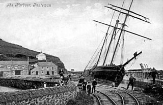
The Pentewan Railway was a 2 ft 6 in narrow gauge railway in Cornwall, England. It was built as a horse-drawn tramway carrying china clay from St Austell to a new harbour at Pentewan, and was opened in 1829. In 1874 the line was strengthened for locomotive working. It finally succumbed to more efficient operation at other ports and closed in 1918.

The Redruth and Chasewater Railway was an early mineral railway line in Cornwall, England, UK. It opened in 1825 and was built to convey the output from copper mines in the Gwennap area to wharves on Restronguet Creek around Devoran, and to bring in coal to fuel mine engines; later it carried timber for pit props and also house coal.

<span class="mw-page-title-main">Hayle Railway</span>

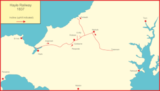
The Hayle Railway was an early railway in West Cornwall, constructed to convey copper and tin ore from the Redruth and Camborne areas to sea ports at Hayle and Portreath. It was opened in 1837, and carried passengers on its main line from 1843.

<span class="mw-page-title-main">John Taylor (mining engineer)</span> British civil engineer and mining engineer

John Taylor was a British mining engineer.

<span class="mw-page-title-main">Devoran</span> Village in south Cornwall, England

<span class="mw-page-title-main">Great County Adit</span> Series of interconnected drainage adits in Cornwall, England

The Great County Adit, sometimes called the County Adit, or the Great Adit was a system of interconnected adits that helped drain water from the tin and copper mines in the Gwennap area of Cornwall, in the United Kingdom. Construction started in 1748 and it eventually reached a length of over 40 miles (64 km) of a tunnel, providing drainage to over 100 mines at an average depth of 80–100 metres (260–330 ft).

<span class="mw-page-title-main">Wheal Gorland</span> Former metalliferous mine in Cornwall, England

Wheal Gorland was a metalliferous mine located just to the north-east of the village of St Day, Cornwall, in England, United Kingdom. It was one of the most important Cornish mines of the late 18th and early 19th centuries, both for the quantity of ore it produced and for the wide variety of uncommon secondary copper minerals found there as a result of supergene enrichment. It is the type locality for the minerals chenevixite, clinoclase, cornwallite, kernowite and liroconite.

<span class="mw-page-title-main">Wheal Busy</span> Disused metalliferous mine in Cornwall, England

Wheal Busy, sometimes called Great Wheal Busy and in its early years known as Chacewater Mine, was a metalliferous mine halfway between Redruth and Truro in the Gwennap mining area of Cornwall, England. During the 18th century the mine produced enormous amounts of copper ore and was very wealthy, but from the later 19th century onwards was not profitable. Today the site of the mine is part of the Cornwall and West Devon Mining Landscape World Heritage Site.

<span class="mw-page-title-main">East Pool mine</span> Former metalliferous mine in Cornwall, England

East Pool mine, was a metalliferous mine in the Camborne and Redruth mining area, just east of the village of Pool in Cornwall, England. Worked from the early 18th century until 1945, first for copper and later tin, it was very profitable for much of its life. Today the site has two preserved beam engines and is part of the Cornwall and West Devon Mining Landscape World Heritage Site. It is owned by the National Trust.

<span class="mw-page-title-main">Consolidated Mines</span> Former metalliferous mine in Cornwall, England

Consolidated Mines, also known as Great Consolidated mine, but most commonly called Consols or Great Consols was a metalliferous mine about a mile ESE of the village of St Day, Cornwall, England. Mainly active during the first half of the 19th century, its mining sett was about 600 yards north–south; and 2,700 yards east–west, to the east of Carharrack. Although always much troubled by underground water, the mine was at times highly profitable, and it was the largest single producer of copper ore in Cornwall. Today the mine is part of the Cornwall and West Devon Mining Landscape World Heritage Site.

<span class="mw-page-title-main">Chycoose</span>

Chycoose, Point and Penpol form a coastal settlement around Penpol Creek in Cornwall, England, United Kingdom.

Scorrier House, located near the village of Scorrier, Cornwall, England, UK, is a country house and the seat of the Williams family. Scorrier House is also home to an important Cornish garden, Scorrier House Stud and, more recently, the Great Estate Festival

References

  1. 1 2 Michael Tangye, Portreath: Some Chapters in its History, self-published by Tangye, Redruth, 1968 and 1978
  2. Tehidy accounts, quoted in Tangye
  3. 1 2 3 R Hansford Worth, Early Western Railroads, Transactions of the Plymouth Institution and Devon and Cornwall Natural History Society, 1887-8, reprinted by Avon Anglia Publications and Services, undated, ISBN   0 905466 46 2
  4. 1 2 Barton, D. Bradford (1966). The Redruth and Chasewater Railway 1824-1915. Truro: D. Bradford Barton Ltd. p. 14.
  5. 1 2 3 Fairclough, A (1970). The Story of Cornwall's Railways. Truro: Tor Mark Press. pp. 7–8.
  6. Barton, page 30
  7. Barton, page 47
  8. R Symons C.E., A Geographical Dictionary or Gazetteer of the County of Cornwall, Penzance, 1884
  9. Stengelhofen, John (1988). Cornwall's Railway Heritage. Truro: Twelveheads Press. p. 4. ISBN   0-906294-16-9.