A postal code is a series of letters or digits or both, sometimes including spaces or punctuation, included in a postal address for the purpose of sorting mail.

A ZIP Code is a system of postal codes used by the United States Postal Service (USPS). The term ZIP was chosen to suggest that the mail travels more efficiently and quickly when senders use the code in the postal address.
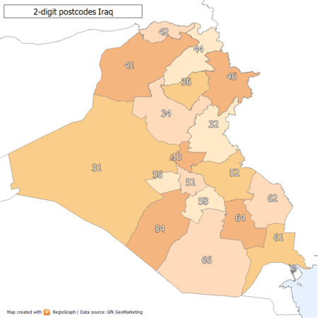
Telecommunications in Iraq include radio, television, fixed and mobile telephones, and the Internet as well as the postal system.

Postal codes used in the United Kingdom, British Overseas Territories and Crown dependencies are known as postcodes. They are alphanumeric and were adopted nationally between 11 October 1959 and 1974, having been devised by the General Post Office.

Lewis Paul Bremer III is a retired American diplomat. He was the second de facto head of state of Iraq as leader of the Coalition Provisional Authority (CPA) following the 2003 invasion of Iraq by the United States, from May 2003 until June 2004.

A Canadian postal code is a six-character string that forms part of a postal address in Canada. Like British, Irish and Dutch postcodes, Canada's postal codes are alphanumeric. They are in the format A1A 1A1, where A is a letter and 1 is a digit, with a space separating the third and fourth characters. As of October 2019, there were 876,445 postal codes using Forward Sortation Areas from A0A in Newfoundland to Y1A in Yukon.

The postal counties of the United Kingdom, now known as former postal counties, were postal subdivisions in routine use by the Royal Mail until 1996. The purpose of the postal county – as opposed to any other kind of county – was to aid the sorting of mail by differentiating between like-sounding post towns. Since 1996 this has been done by using the outward code of the postcode instead. For operational reasons the former postal counties, although broadly based on the counties of the United Kingdom, did not match up with their boundaries: in some cases there were significant differences. The boundaries changed over time as post towns were created or amended.
The Law of Administration for the State of Iraq for the Transitional Period, also called the Transitional Administrative Law or TAL, was Iraq's provisional constitution following the 2003 Iraq War. It was signed on March 8, 2004 by the Iraqi Governing Council. It came into effect on June 28, 2004 following the official transfer of power from the Coalition Provisional Authority to a sovereign Iraqi government. The law remained in effect until the formation of the government in May 2006, when it was superseded by the permanent constitution that had been approved by referendum on October 15, 2005.
Investment in post-2003 Iraq refers to international efforts to rebuild the infrastructure of Iraq since the Iraq War in 2003. Along with the economic reform of Iraq, international projects have been implemented to repair and upgrade Iraqi water and sewage treatment plants, electricity production, hospitals, schools, housing, and transportation systems. Much of the work has been funded by the Iraq Relief and Reconstruction Fund, and the Coalition Provisional Authority.
This is a survey of the postage stamps and postal history of Iraq. It includes special uses under the Ottoman Empire as well as occupation issues.

An address is a collection of information, presented in a mostly fixed format, used to give the location of a building, apartment, or other structure or a plot of land, generally using political boundaries and street names as references, along with other identifiers such as house or apartment numbers and organization name. Some addresses also contain special codes, such as a postal code, to make identification easier and aid in the routing of mail.
A post town is a required part of all postal addresses in the United Kingdom and Ireland, and a basic unit of the postal delivery system. Including the correct post town in the address increases the chance of a letter or parcel being delivered on time. Post towns in general originated as the location of delivery offices. As of 2004, their main function is to distinguish between localities or street names in addresses not including a postcode.
The Central Criminal Court of Iraq, or CCCI, is a criminal court of Iraq. The CCCI is based on an inquisitorial system and consists of two chambers: an investigative court and a criminal court. The court was created by the Coalition Provisional Authority in 2003 to handle cases involving serious crimes such as governmental corruption, terrorism and organized crime that were previously handled by governorate level judges in the ordinary criminal courts. Candidates for the judiciary had to be an Iraqi national of high moral character and reputation, a non-member of the Ba'ath Party, demonstrate a "high level of legal competence", and sign an oath of office.
In May 2003, following the invasion of Iraq in March of that year, the Central Bank of Iraq-Development Fund for Iraq (DFI) account was created at the U.S. Federal Reserve Bank of New York at the request of the Coalition Provisional Authority (CPA) Administrator. A part of the fund has been transferred to Baghdad and Iraq, and the DFI-Baghdad account was opened at the Central Bank of Iraq "for cash payment requirements". The fund also eventually received money from seized and "vested" Iraqi bank accounts and funds seized by coalition forces. $650 million of this amount belongs to Uday Saddam Hussein, the older son of the former Iraqi president. The DFI have been disbursed mainly for "the wheat purchase program, the currency exchange program, the electricity and oil infrastructure programs, equipment for Iraqis security forces, and for Iraqi civil service salaries and ministry budget operations".

South Humberside is a former postal county of England. It was introduced by the Royal Mail on 1 July 1974, when some addresses were altered in response to the changes in administration brought about under the Local Government Act 1972.
Adnan al-Zurfi was chosen as the new prime minister-designate on 17 March 2020 by Iraqi President Barham Salih after Mohammad Allawi withdrew his nomination. Al-Zurfi withdrew from forming a new government on 9 April 2020. He was appointed by Paul Bremer, the Coalition Provisional Authority administrator, as governor of Najaf Governorate in July 2004.

The Palestinian National Authority began in 1994 to issue stamps and operate postal services as authorized by the Oslo Accords.

The following outline is provided as an overview of and topical guide to Iraq:
The 100 Orders are "binding instructions or directives to the Iraqi people that create penal consequences or have a direct bearing on the way Iraqis are regulated, including changes to Iraqi law" created in early 2004 by Paul Bremer under the Coalition Provisional Authority in Iraq. The orders called for the de-Baathification of Iraq as well as extensive economic changes. Most of the economic changes are focused on transitioning the economy of Iraq from a centrally planned economy to a market economy, as outlined in the contract by BearingPoint: