Manitou Beach–Devils Lake is a census-designated place (CDP) in Lenawee County in the U.S. state of Michigan. The population of the CDP was 2,019 at the 2010 census. It is located within Rollin Township to the south and Woodstock Township to the north.

Porte des Morts, also known as Porte des Mortes, the Door of Death, and Death's Door is a strait linking Lake Michigan and Green Bay between the northern tip of the Door Peninsula and the southernmost of the Potawatomi Islands. At its narrowest reach between Plum Island and the peninsula, the Porte des Morts Passage is about one and one third miles across. The name is French and means "door of the dead".

The Door Peninsula is a peninsula in eastern Wisconsin, separating the southern part of the Green Bay from Lake Michigan. The peninsula includes northern Kewaunee County, northeastern Brown County, and the mainland portion of Door County. It is on the western side of the Niagara Escarpment. Well known for its cherry and apple orchards, the Door Peninsula is a popular tourism destination. With the 1881 completion of the Sturgeon Bay Ship Canal, the northern half of the peninsula became an island.

Voinjama District is one of six districts located in Lofa County, Liberia.
Finn Creek Provincial Park is a provincial park in British Columbia, Canada, north of Avola and Blue River in the valley of the North Thompson River.
Federal Point is an unincorporated community in Putnam County, Florida, United States, located northwest of Hastings, on the eastern bank of the St. Johns River.

Sar is a comarca in the province of A Coruña, Galicia, western Spain. The overall population of this local region is 17,354 (2005).

Stillwater is an unincorporated community in eastern Rush Township, Tuscarawas County, Ohio, United States. It has a post office with the ZIP code 44679. It lies at the intersection of State Routes 258 and 800.
The Potawatomi Islands is the most common historic name given to the string of islands that delineate the transition from Green Bay to Lake Michigan, one of the Great Lakes. The archipelago is also termed the "Grand Traverse Islands".

Roseland is an unincorporated community in Nelson County, Virginia, United States. It was among the communities severely affected by flash flooding from Hurricane Camille in 1969.
CRG Gallery was an art gallery on New York City's Lower East Side, located at 195 Chrystie St. CRG was founded in 1990 by Carla Chammas, Richard Desroche, and Glenn McMillan.
Kakhrylyar is a village in the Tartar Rayon of Azerbaijan.
Pələkli is a village in the Tovuz Rayon of Azerbaijan. The village forms part of the municipality of Çatax.

Kiillinnguyaq, formerly the Kent Peninsula, is a large Arctic peninsula, almost totally surrounded by water, in the Kitikmeot Region of Nunavut. Were it not for a 8.0 km (5 mi) isthmus at the southeast corner it would be a long island parallel to the coast. From the isthmus it extends 169 km (105 mi) westward into the Coronation Gulf. To the south, Melville Sound separates it from the mainland. To the north is Dease Strait and then Victoria Island. To the west is Coronation Gulf and to the east, Queen Maud Gulf. Cape Flinders marks the western tip of the peninsula, Cape Franklin is at the northwestern point, and Hiiqtinniq, formerly Cape Alexander marks the northeastern point.
Međuhana is a village in the municipality of Blace, Serbia. According to the 2002 census, the village had a population of 187 people.
Zagorica is a village in the municipality of Topola, Serbia. According to the 2002 census, the village has a population of 765 people.
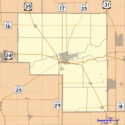
Indian Creek is a stream in the U.S. state of Indiana. It is a tributary of the Tippecanoe River.
Rockford is an unincorporated community in Tuscarawas County, in the U.S. state of Ohio.

Wyandot was a small town, now extinct, in Sheffield Township, Tippecanoe County, in the U.S. state of Indiana.
Marco is an unincorporated community in Stoddard County, in the U.S. state of Missouri.