
Arroyo Hondo is a northwestward-flowing 13.0-mile-long (20.9 km) river in Santa Clara County, California, United States, that lies east of Milpitas. The area is privately owned by the San Francisco Water Department and is closed to public access because of its usage as drinking water. Bounded to the east by Oak Ridge and to the west by Poverty Ridge, Arroyo Hondo empties into the Calaveras Reservoir where it joins Calaveras Creek. It is formed by the confluence of Smith Creek and Isabel Creek which drain the west and east slopes of Mount Hamilton, respectively.
Oak Ridge in Santa Clara County, California, is a ridge forming the east canyon wall of Arroyo Hondo, which drains into Calaveras Reservoir. Black Mountain is its highest point. The first known white settlers on Oak Ridge were the Parks family, who ran cattle on the ridge. Now owned by the San Francisco Water Department, the ridge is private property and is off-limits to most people.
Calaveras Valley is a valley east of Milpitas, California in the San Francisco Bay Area. It has formed primarily as a result of the actions of the Calaveras Fault. The southern end of the Calaveras Valley is a few miles south of Calaveras Reservoir, while the northern end is at Sunol.

Berryessa Creek is a seasonal creek in northeastern San Jose and Milpitas. Its main source is located in the Los Buellis Hills slightly west of Felter Road. Berryessa Creek has many tributaries, including Piedmont Creek, Calera Creek, and Penitencia Creek. In the summer, Berryessa Creek is mostly dry except in Milpitas, where much of its water comes from urban runoff and tributaries. In winter, however, the creek can flood very high and pose a hazard for surrounding residences. The creek was named after a member of the prominent Basque–Spanish Berreyesa family: Nicolas Berreyesa, a Californio settler granted the Rancho Milpitas in 1834.
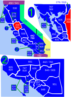
Area code 209 is the California telephone area code that was split from area code 415 on October 26, 1957. It covers Stockton, Modesto, Turlock, Merced, Winton, Atwater, Livingston, Manteca, Ripon, Tracy, Lodi, Galt, Sonora, Los Banos, San Andreas, Mariposa, and Yosemite, the northern San Joaquin Valley, and the Sierra Foothills.
The Clayton-Marsh Creek-Greenville Fault is a fault located in the eastern San Francisco Bay Area of California, in Alameda County and Contra Costa County. It is part of the somewhat parallel system of faults that are secondary to the San Andreas Fault.

Smith Creek is a 14-mile-long (23 km) perennial stream which flows along the western flank of Mount Hamilton in Santa Clara County. The creek begins near Bollinger Ridge, about 7.7 km SxSW of Mount Hamilton.
Bishop Ranch Regional Preserve (BRRP), also known as Bishop Ranch Regional Open Space Preserve is a 444-acre (1.80 km2) regional park on a ridge top at the edge of San Ramon, CA. It is near residential area, west of San Ramon Valley Road and South of Bollinger Canyon Road. Trails are steep and there are no facilities other than a trailhead. It is part of the East Bay Regional Parks system.
Diablo Foothills Regional Park is a 1,060 acres (4.3 km2) regional park of the East Bay Regional Park District. It is located in Contra Costa County, in the East Bay region of northern California.
The Berry Creek Rancheria of Tyme Maidu Indians are a Native American people inhabiting a northeastern part California, south of Lassen Peak.

Calaveras Creek is a northward-flowing stream in Alameda and Santa Clara counties of California. It runs for 8.5 miles (13.7 km), starting from Poverty Ridge, passing through Calaveras Reservoir, and emptying into Alameda Creek east of Fremont, California.

Copper Cove Subdivision is an unincorporated community in Calaveras County, California. It lies at an elevation of 1070 feet.
Lilac Park is an unincorporated community in Arnold, California in Calaveras County, California. Lilac Park Subdivision was approved by the CA Dept of Real Estate in February 1956. Arnold Lilac Park Homeowners Association (ALPHA) was incorporated on February 23, 1959. There are 205 home sites in ALPHA, not all are improved. The east side of Lilac Park sits atop Rocky Ridge and the west side follows SR 4. The community rests on a west facing slope.
Amador Valley is a valley in eastern Alameda County, California and is the location of the cities of Dublin and Pleasanton. The valley is bounded by the foothills of the Diablo Range on the north and south, Pleasanton Ridge to the west, and Livermore Valley to the east.
Elsinore Mountains, a ridge of mountains within the larger range of the Santa Ana Mountains, in the Cleveland National Forest, Riverside County, California, United States. the tallest peaks within the range is the unofficially named San Mateo Peak at 3,591 ft (1,095 m). Second is officially named Elsinore Peak at 3,536 ft (1,078 m). The Elsinore Mountanins run in a ridge from just east of El Cariso, southeast to Elsinore Peak. Beyond that peak the ridge begins to descend and curves to the east. From Elsinore Peak, a ridge runs to the west and then northwest to San Mateo Peak, enclosing the Morrell Potrero on the south and west.

Isabel Creek is a 18-mile-long (29 km) perennial stream which flows northwesterly along the eastern then northern flank of Mount Hamilton in Santa Clara County. It joins Smith Creek to form Arroyo Hondo north of Mt. Hamilton and is part of the southernmost Alameda Creek watershed.
Dublin Hills Regional Park covers 654 acres (2,650,000 m2) in Alameda County, California, west of the city of Dublin. It is part of the East Bay Regional Park District (EBRPD). The park is accessible from the Donlon Hill Staging Area, which is on Dublin Boulevard near Dublin, California.
North Fork Orestimba Creek is a tributary stream of Orestimba Creek, in the Diablo Range in Stanislaus County, California. Its mouth lies at an elevation of 673 feet / 205 meters at its confluence with South Fork Orestimba Creek where it forms the head of Orestimba Creek, itself a tributary of the San Joaquin River. Its source is at an elevation of 3,250 feet / 991 meters at 37°20′37″N121°24′44″W on the north slope of the northern ridge of Black Mountain.
East Fork Pacheco Creek is a 5 mile long tributary stream of North Fork Pacheco Creek in the Diablo Range in Santa Clara County, California. Its confluence with the North Fork is at an elevation of 610 feet / 186 meters. Its source is located about a half mile nortnortheast of the Fifield Ranch at 37°08′07″N121°13′47″W at an elevation of 1600 feet / 488 meters just west of County Line Road that runs along the crest of the Diablo Range between Santa Clara County and Stanislaus County, California about a quarter mile before its intersection with the Fifield Grade and McCabe Road that climbs upward from the canyon of Romero Creek on the east slope of the Diablo Range in Merced County, California.
Red Hill is a summit on the eastern slope of the Diablo Range, in Merced County, California. Its highest elevation is 2,326 feet / 709 meters. The summit is part of a long ridge where its high point is between 37°07′35″N121°11′31″W and 37°07′27″N121°11′50″W. The Red Mountain Road, runs over this ridge between Fifield Road on the divide of the Diablo Range and McCabe Road on Romero Creek.


