Arroyo Hondo (Santa Clara County, California)

Last updated
Arroyo Hondo
ArroyoHondo. AlamedaCo.RALeidy.jpg
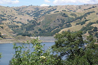
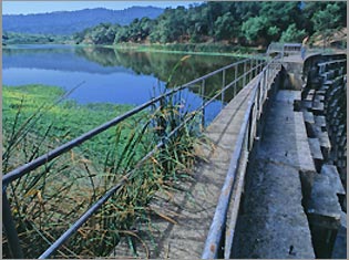
Summer low flows in Arroyo Hondo with riparian white alder and foothill pine, Courtesy of Robert A. Leidy PhD, U.S. EPA
Location
Country United States
State California
Region Santa Clara County
Physical characteristics
SourceConfluence of Smith Creek and Isabel Creek
 - coordinates 37°23′00″N121°41′34″W / 37.38333°N 121.69278°W / 37.38333; -121.69278 [1]
 - elevation1,585 ft (483 m)
Mouth Joins Calaveras Creek in Calaveras Reservoir
 - coordinates
37°27′51″N121°46′36″W / 37.46417°N 121.77667°W / 37.46417; -121.77667 Coordinates: 37°27′51″N121°46′36″W / 37.46417°N 121.77667°W / 37.46417; -121.77667 [1]
 - elevation
771 ft (235 m) [1]

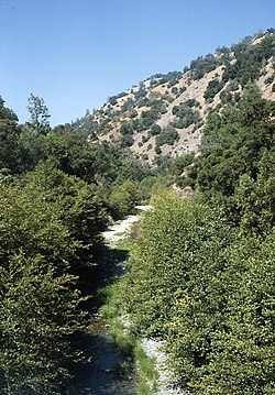
Arroyo Hondo is a northwestward-flowing 13.0-mile-long (20.9 km) [2] river in Santa Clara County, California, United States, that lies east of Milpitas. [1] The area is privately owned by the San Francisco Water Department and is closed to public access because of its usage as drinking water. Bounded to the east by Oak Ridge and to the west by Poverty Ridge, Arroyo Hondo empties into the Calaveras Reservoir where it joins Calaveras Creek. It is formed by the confluence of Smith Creek and Isabel Creek which drain the west and east slopes of Mount Hamilton, respectively.

Santa Clara County, California County in California, United States

Santa Clara County, officially the County of Santa Clara, is California's 6th most populous county, with a population of 1,781,642, as of the 2010 census. The county seat and largest city is San Jose, the 10th most populous city in the United States and California's 3rd most populous city.

Milpitas, California City in California

Milpitas is a city in Santa Clara County, California. It is located with San Jose to its south and Fremont to its north, at the eastern end of State Route 237 and generally between Interstates 680 and 880 which run roughly north/south through the city. With Alameda County bordering directly on the north, Milpitas sits in the extreme northeast section of the South Bay, bordering the East Bay and Fremont. Milpitas is also located within the Silicon Valley. The corporate headquarters of SonicWall, Maxtor, LSI Corporation, Adaptec, Intersil, FireEye, Viavi and Lumentum, KLA-Tencor, and View, Inc. sit within the industrial zones of Milpitas. Flex and Cisco also have offices in Milpitas. The population was 78,106 at the 2018 census.

Oak Ridge in Santa Clara County, California, is a ridge forming the east canyon wall of Arroyo Hondo, which drains into Calaveras Reservoir. Black Mountain is its highest point. The first known white settlers on Oak Ridge were the Parks family, who ran cattle on the ridge. Now owned by the San Francisco Water Department, the ridge is private property and is off-limits to most people.

Contents

History

Arroyo Hondo means "deep creek" in Spanish. Its Isabel Creek tributary is significant in that the Spanish name for Mt. Hamilton was the Sierra de Santa Isabel, and the highest point was then referred to as Mount Isabel instead of Mount Hamilton. When William Henry Brewer and Charles Hoffman of the Whitney Survey climbed the peak on August 26, 1861, they did not know it had a name, and christened it Mt. Hamilton, although they did correctly place Isabel Valley on their map to the east. When in 1895, the USGS realized that the peak two miles southeast of Mt. Hamilton was as tall (4,193-foot (1,278 m), [3] they correctly named it Mt. Isabel. [4]

Spanish language Romance language

Spanish or Castilian, is a Western Romance language that originated in the Castile region of Spain and today has hundreds of millions of native speakers in the Americas and Spain. It is a global language and the world's second-most spoken native language, after Mandarin Chinese.

Isabel Creek river in the United States of America

Isabel Creek is a 18-mile-long (29 km) perennial stream which flows northwestly along the eastern then northern flank of Mount Hamilton in Santa Clara County. It joins Smith Creek to form Arroyo Hondo north of Mt. Hamilton and is part of the southernmost Alameda Creek watershed.

William Henry Brewer American botanist

William Henry Brewer was an American botanist. He worked on the first California Geological Survey and was the first Chair of Agriculture at Yale University's Sheffield Scientific School.

Watershed

The Arroyo Hondo mainstem is formed by the confluence of Isabel Creek and Smith Creek at the northern tip of Joseph D. Grant County Park at an elevation of 1,585 feet (483 m) above sea level. [5] It flows northerly to its confluence with Calaveras Reservoir at an elevation of 765 feet. [1] Isabel Creek begins at about 2,600 feet (790 m) about one mile south of Mt. Helen, then flows north through the Isabel Valley, then east and north of Mt. Isabel and Mt. Hamilton until it is joined by Smith Creek. [5] Arroyo Hondo joins Calaveras Creek in Calaveras Reservoir. Calaveras Creek is, in turn, tributary to Alameda Creek in Alameda County, California and ultimately flows into San Francisco Bay.

Smith Creek (Santa Clara County, California)

Smith Creek is a 14-mile-long (23 km) perennial stream which flows along the western flank of Mount Hamilton in Santa Clara County. The creek begins near Bollinger Ridge, about 7.7 km SxSW of Mount Hamilton.

Calaveras Reservoir

Calaveras Reservoir is located primarily in Santa Clara County, California, with a small portion and its dam in Alameda County, California. The reservoir capacity is seismically restricted, approximately 30,000 acre⋅ft (37,000,000 m3). In Spanish, Calaveras means "skulls".

Calaveras Creek is a waterway that starts near Martinez, Texas and runs for fifteen miles to its mouth at the San Antonio River. It is the source of Calaveras Lake where it is dammed near Elmendorf. Calaveras means skulls in Spanish.

Ecology

Arroyo Hondo still has remnants of native coastal rainbow trout (Oncorhynchus mykiss irideus), which several conservation organizations have attempted to protect. Impassable falls are now present on upper Arroyo Hondo, but the rainbow trout in its Smith and Isabel creek tributaries are assumed to be native, as California roach (Hesperoleucus symmetricus) and Sacramento sucker (Catostomus occidentalis occidentalis) are also present above and below the falls. [6] [7] The California Academy of Sciences collected a steelhead trout specimen in 1898 on Isabel Creek. [8] Also, both Smith Creek and Arroyo Hondo were recorded in 1905 by John Otterbein Snyder as anadromous steelhead trout (Oncorhynchus mykiss irideus) streams. [9] [10] Speckled dace (Rhinichthys osculus) were collected by John Otterbein Snyder in 1898 in Arroyo Hondo and Isabel creeks, but not by Scoppettone and Smith in 1978, nor by Leidy and Bronwen in 2013, and their status in the creek remains uncertain as is true of most of their former sites in the central coast. [11] [12]

Rainbow trout species of trout

The rainbow trout is a trout and species of salmonid native to cold-water tributaries of the Pacific Ocean in Asia and North America. The steelhead is an anadromous (sea-run) form of the coastal rainbow trout(O. m. irideus) or Columbia River redband trout (O. m. gairdneri) that usually returns to fresh water to spawn after living two to three years in the ocean. Freshwater forms that have been introduced into the Great Lakes and migrate into tributaries to spawn are also called steelhead.

California roach species of cyprinid fish, native to western North America

The California roach is a cyprinid fish native to western North America and abundant in the intermittent streams throughout central California. Once considered the sole member of its genus, it has recently been split into a number of closely related species and subspecies.

<i>Catostomus</i> genus of fishes

Catostomus is a genus of fish belonging to the family Catostomidae, commonly known as suckers. Most members of the genus are native to North America, but C. catostomus is also found in Russia. Fish from different species of the genus are known to readily hybridize with each other.

Foothill yellow-legged frogs (Rana boylei) and California red-legged frogs (Rana draytoni) are present in Upper Alameda, Arroyo Hondo, Smith, and Isabel creeks. [6]

Foothill yellow-legged frog species of amphibian

The foothill yellow-legged frog is a small-sized 3.72–8.2 cm (1.46–3.23 in) frog from the genus Rana in the family Ranidae. This species can be found in the Coast Ranges from northern Oregon, through California, and into Baja California, Mexico as well as in the foothills of the Sierra Nevada and southern Cascade Range in California. The foothill yellow-legged frog is a Federal Species of Concern and California Species of Special Concern.

California red-legged frog species of amphibian

The California red-legged frog is a species of frog found in California (USA) and northern Baja California (Mexico). It was formerly considered a subspecies of the northern red-legged frog. The frog is an IUCN vulnerable species, and a federally listed threatened species of the United States, and is protected by law.

See also

Related Research Articles

Coyote Creek (Santa Clara County)

Coyote Creek is a river that flows through the Santa Clara Valley in California, United States.

Stevens Creek (California) river in the United States of America

Stevens Creek is a creek in Santa Clara County, California. The creek originates in the Santa Cruz Mountains on the western flank of Black Mountain in the Monte Bello Open Space Preserve near the terminus of Page Mill Road at Skyline Boulevard. It flows southeasterly through the Stevens Creek County Park before turning northeast into Stevens Creek Reservoir. It then continues north for 12.5 miles through Cupertino, Los Altos, Sunnyvale and Mountain View before emptying into the San Francisco Bay at the Whisman Slough, near Google's main campus.

Alameda Creek river in the United States of America

Alameda Creek is a large perennial stream in the San Francisco Bay Area. The creek runs for 45 miles (72 km) from a lake northeast of Packard Ridge to the eastern shore of San Francisco Bay by way of Niles Canyon and a flood control channel.

Los Gatos Creek (Santa Clara County, California) river in the United States of America

The Los Gatos Creek runs 24 miles (39 km) in California through Santa Clara Valley Water District's Guadalupe Watershed from the Santa Cruz Mountains northward through the Santa Clara Valley until its confluence with the Guadalupe River in downtown San Jose. The Guadalupe River then continues onward into San Francisco Bay.

San Leandro Creek river in the United States of America

San Leandro Creek is a 21.7-mile-long (34.9 km) year-round natural stream in the Berkeley Hills, in Alameda County and Contra Costa County of the East Bay in northern California.

Wildcat Creek (California) river in the United States of America

Wildcat Creek is a 13.4-mile-long (21.6 km) creek which flows through Wildcat Canyon situated between the Berkeley Hills and the San Pablo Ridge, emptying into San Pablo Bay in Contra Costa County, northern California.

Upper Penitencia Creek is actually one of two creeks by the name Penitencia Creek in the northeastern Santa Clara Valley of Santa Clara County, California. They are both tributaries of Coyote Creek. The creek was diverted southwestward to Coyote Creek ca. 1850 by a farmer to irrigate his fields, permanently splitting Upper Penitencia Creek from Lower Penitencia Creek. Upper Penitencia Creek drains the western slopes of Mount Hamilton of the Diablo Range, and passes through Alum Rock Park, before ending at its confluence with Coyote Creek at Berryessa Road.

Marsh Creek (California) river in the United States of America

Marsh Creek is a stream in east Contra Costa County, California in Northern California which rises on the eastern side of Mount Diablo and flows 30 miles (48 km) to the Sacramento–San Joaquin River Delta at Oakley, California, near Big Break Regional Shoreline. The creek flows through Marsh Creek State Park (California), where water is impounded to form Marsh Creek Reservoir, then through the city of Brentwood, California.

Saratoga Creek river in the United States of America

Saratoga Creek is a north-northeast flowing creek in Santa Clara County, California.

Searsville Dam

Searsville Dam is a masonry dam in San Mateo County, California that was completed in 1892, one year after the founding of Stanford University, and impounds Corte Madera Creek to form a reservoir known as Searsville Lake. Searsville Dam is located in the Jasper Ridge Biological Preserve and is owned and operated by Stanford University. Neighboring cities include Woodside and Portola Valley, California.

Corte Madera Creek (San Mateo County, California) river in the United States of America

Corte Madera Creek is a 7.3-mile-long (11.7 km) creek that flows north-northwest to Searsville Dam and then joins with Bear Creek to form San Francisquito Creek in California.

San Tomas Aquino Creek river in the United States of America

San Tomas Aquinas Creek, known locally as San Tomas Aquino Creek, is a 16.5-mile-long (26.6 km) stream that heads on El Sereno mountain in El Sereno Open Space Preserve in Saratoga, California in Santa Clara County, California, United States. It flows north through the cities of Saratoga, Monte Sereno, Los Gatos, Campbell, Santa Clara and San Jose before its confluence with the Guadalupe Slough in south San Francisco Bay.

Alambique Creek river in the United States of America

Alambique Creek, or Arroyo Alembique, is a 2.7-mile-long (4.3 km) stream located in San Mateo County, California in the United States. It is part of the San Francisquito Creek watershed.

Cordilleras Creek is a 3.8-mile-long (6.1 km) northward-flowing stream originating in the Pulgas Ridge Open Space Preserve in the foothills of the Santa Cruz Mountains. It forms the border between San Carlos and Redwood City in San Mateo County, California, United States before entering Smith Slough where its waters course to Steinberger Slough and thence to San Francisco Bay.

San Felipe Creek is a 14 miles (23 km) stream that originates in the western Diablo Range in Santa Clara County, California. It flows south by southeast through two historic ranchos, Rancho Los Huecos and Rancho Cañada de San Felipe y Las Animas before it joins Las Animas Creek just above Anderson Reservoir. One of the nine major tributaries of Coyote Creek, the creek’s waters pass through the Santa Clara Valley and San Jose on the way to San Francisco Bay.

San Antonio Creek is a 24.4-kilometre-long (15.2 mi) northwesterly-flowing stream originating on the eastern edge of Santa Clara County just west of its border with Stanislaus County.

Arroyo Bayo river in the United States of America

Arroyo Bayo is an 8-mile-long (13 km) perennial stream which flows northwestly along Mount Hamilton Road east of Mt. Hamilton in the Diablo Range. It is part of the southern Alameda Creek watershed in Santa Clara County, California.

References

  1. 1 2 3 4 5 U.S. Geological Survey Geographic Names Information System: Arroyo Hondo
  2. U.S. Geological Survey. National Hydrography Dataset high-resolution flowline data. The National Map Archived 2012-04-05 at WebCite , accessed March 15, 2011
  3. U.S. Geological Survey Geographic Names Information System: Arroyo Hondo (Santa Clara County, California)
  4. Erwin G. Gudde; William Bright (2004). California Place Names: The Origin and Etymology of Current Geographical Names. University of California Press. p. 179. Retrieved 2010-11-21.
  5. 1 2 U.S. Geological Survey Geographic Names Information System: Isabel Creek
  6. 1 2 Jerry J. Smith (July 25, 2013). Northern Santa Clara County Fish Resources (PDF) (Report). San Jose State University. Retrieved March 12, 2016.
  7. Jerry J. Smith (1998). Steelhead and Other Fish Resources of Western Mt. Hamilton Streams (PDF) (Report). San Jose, California: San Jose State University. Retrieved 2016-03-04.
  8. "Oncorhynchus mykiss gairdnerii". California Academy of Sciences Ichthyology Collection. Retrieved 2010-11-19.
  9. John Otterbein Snyder, United States Bureau of Fisheries (1905). Notes on the fishes of the streams flowing into San Francisco Bay, California in Report of the Commissioner of Fisheries to the Secretary of Commerce and Labor for the fiscal year ending June 30, 1904. 30. General Printing Office. p. 337. Retrieved 2011-08-28.
  10. Robert A. Leidy; Gordon Becker; Brett N. Harvey (2005). Historical Distribution and Current Status of Steelhead/Rainbow Trout (Oncorhynchus mykiss) in Streams of the San Francisco Estuary, California (PDF) (Report). Center for Ecosystem Management and Restoration. p. 123. Archived (PDF) from the original on 25 July 2011. Retrieved 2011-08-28.
  11. Jerry J. Smith (1998). Steelhead and Other Fish Resources of Western Mt. Hamilton Streams (PDF) (Report). San Jose, California: San Jose State University. Retrieved 2016-03-04.
  12. Alameda Creek Watershed Historical Ecology Study (Table 8.4) (PDF) (Report). San Francisco Estuary Institute (SFEI). 2013. Retrieved March 12, 2016.