Smith Creek (Santa Clara County, California)

Last updated
Smith Creek
stream
Leidy 2009 Smith Creek in July 2009 upstream from Mt. Hamilton Road bridge crossing.JPG
View upstream of Smith Creek at Mt. Hamilton Road crossing with California bay laurel and white alder, courtesy of Robert A. Leidy PhD, U.S. EPA
Country United States
State California
Region Santa Clara County
Tributaries
 - rightCastle Canyon, Sulphur Creek
SourceNorthwestern slope of Bollinger Ridge in the Diablo Range
 - elevation3,520 ft (1,073 m)
 - coordinates 37°16′39″N121°33′41″W / 37.27750°N 121.56139°W / 37.27750; -121.56139   [1]
MouthConfluence with Isabel Creek to form source of Arroyo Hondo
 - elevation1,585 ft (483 m) [1]
 - coordinates 37°23′00″N121°41′34″W / 37.38333°N 121.69278°W / 37.38333; -121.69278 Coordinates: 37°23′00″N121°41′34″W / 37.38333°N 121.69278°W / 37.38333; -121.69278   [1]

Smith Creek is a 14-mile-long (23 km) [2] [3] perennial stream which flows along the western flank of Mount Hamilton in Santa Clara County. The creek begins near Bollinger Ridge, about 7.7 km SxSW of Mount Hamilton.

A perennial stream or perennial river is a stream or river (channel) that has continuous flow in parts of its stream bed all year round during years of normal rainfall. "Perennial" streams are contrasted with "intermittent" streams which normally cease flowing for weeks or months each year, and with "ephemeral" channels that flow only for hours or days following rainfall. During unusually dry years, a normally perennial stream may cease flowing, becoming intermittent for days, weeks, or months depending on severity of the drought. The boundaries between perennial, intermittent, and ephemeral channels are not defined, and subject to a variety of identification methods adopted by local governments, academics, and others with a need to classify stream-flow permanence.

Mount Hamilton (California) mountain in United States of America

Mount Hamilton is a mountain in California's Diablo Range, in Santa Clara County, California. Mount Hamilton, at 4,265 feet (1,300 m) is a mountain overlooking Santa Clara Valley and is the site of Lick Observatory, the World's first permanently occupied mountain-topobservatory. The asteroid 452 Hamiltonia, discovered in 1899, is named after the mountain. Golden eagle nesting sites are found on the slopes of Mount Hamilton. On clear days, Mount Tamalpais, the Santa Cruz Mountains, Monterey Bay, the Monterey Peninsula, and even Yosemite National Park are visible from the summit of the mountain.

Santa Clara County, California County in California, United States

Santa Clara County, officially the County of Santa Clara, is California's 6th most populous county, with a population of 1,781,642, as of the 2010 census. The county seat and largest city is San Jose, the 10th most populous city in the United States and California's 3rd most populous city.

Contents

History

Some of the early recorded history of the Smith Creek watershed is associated with the pioneer family of the Winsors. [4]

Settler person who has migrated to an area and established permanent residence there

A settler is a person who has migrated to an area and established a permanent residence there, often to colonize the area. Settlers are generally from a sedentary culture, as opposed to nomads who share and rotate their settlements with little or no concept of individual land ownership. Settlements are often built on land already claimed or owned by another group. Many times settlers are backed by governments or large countries. They also sometimes leave in search of religious freedom.

Where Mt. Hamilton Road crosses Smith Creek, there used to be the Hotel Santa Ysabel. [5]

Watershed and course

Smith Creek arises at 3,520 feet (1,070 m) then flows westerly through Horse Valley, then turns northwest. It receives Sulphur Creek 0.8 miles (1.3 km) before crossing Mount Hamilton Road about 12.7 km west of Mount Hamilton (the Smith Creek Ranger Station/CAL FIRE is located at this crossing at 22805 Mt. Hamilton Road). [6] The creek continues northwest along the eastern boundary of Joseph D. Grant County Park [7] and joins Isabel Creek about 15.3 km WNW of Mount Hamilton at 37°23′00″N121°41′34″W / 37.38333°N 121.69278°W / 37.38333; -121.69278 [8] , forming Arroyo Hondo and eventually joining Calaveras Creek in Calaveras Reservoir. Calaveras Creek exits the reservoir and joins Alameda Creek before final terminating in San Francisco Bay.

California State Route 130 highway in California

State Route 130 is a state highway in the U.S. state of California in Santa Clara County. The route runs between San Jose and Patterson, passing Mount Hamilton on the way. Much of its length goes through the Diablo Range as Mount Hamilton Road, where it is a narrow two-lane highway. The remainder of SR 130 is numbered along Alum Rock Avenue in San Jose.

Isabel Creek river in the United States of America

Isabel Creek is a 18-mile-long (29 km) perennial stream which flows northwestly along the eastern then northern flank of Mount Hamilton in Santa Clara County. It joins Smith Creek to form Arroyo Hondo north of Mt. Hamilton and is part of the southernmost Alameda Creek watershed.

Arroyo Hondo (Santa Clara County, California) river in the United States of America

Arroyo Hondo is a northwestward-flowing 13.0-mile-long (20.9 km) river in Santa Clara County, California, United States, that lies east of Milpitas. The area is privately owned by the San Francisco Water Department and is closed to public access because of its usage as drinking water. Bounded to the east by Oak Ridge and to the west by Poverty Ridge, Arroyo Hondo empties into the Calaveras Reservoir where it joins Calaveras Creek. It is formed by the confluence of Smith Creek and Isabel Creek which drain the west and east slopes of Mount Hamilton, respectively.

Habitat and Ecology

Juvenile rainbow trout briefly electrofished and measured on Smith Creek by Robert A. Leidy PhD, U.S. EPA Juvenile rainbow (Oncorhynchus mykiss) collected during 2009 fish surveys of Smith Creek.jpg
Juvenile rainbow trout briefly electrofished and measured on Smith Creek by Robert A. Leidy PhD, U.S. EPA

Steelhead trout (Oncorhynchus mykiss) are native to Smith Creek, although the construction of Calaveras Dam blocks in-migrating fish. [9] Both Smith Creek and Arroyo Hondo were recorded in 1905 by John Otterbein Snyder as holding anadromous Steelhead trout (Oncorhynchus mykiss) streams. [10] [11]

John Otterbein Snyder was an American ichthyologist and professor of zoology at Stanford University.

Impassable falls are present on upper Arroyo Hondo, but the rainbow trout in Smith and Isabel creeks are assumed to be native, as California roach (Hesperoleucus symmetricus) and Sacramento sucker (Catostomus occidentalis occidentalis) are also present above and below the falls. Speckled dace (Rhinichthys osculus) were collected by John Otterbein Snyder in 1905 in Arroyo Hondo and Isabel creeks, but not by Scoppettone and Smith in 1978, having disappeared from most of their former sites in the central coast. [12]

California roach species of cyprinid fish, native to western North America

The California roach is a cyprinid fish native to western North America and abundant in the intermittent streams throughout central California. Once considered the sole member of its genus, it has recently been split into a number of closely related species and subspecies.

<i>Catostomus</i> genus of fishes

Catostomus is a genus of fish belonging to the family Catostomidae, commonly known as suckers. Most members of the genus are native to North America, but C. catostomus is also found in Russia. Fish from different species of the genus are known to readily hybridize with each other.

Speckled dace species of fish

The speckled dace, also known as the spotted dace and the carpita pinta, is a member of the minnow family. It is found in temperate freshwater in North America, from Sonora, Mexico to British Columbia, Canada.

The invasive, non-native signal crayfish lives along the length of Smith Creek. Foothill yellow-legged frogs (Rana boylei) and California red-legged frogs (Rana draytoni) are present in Upper Alameda, Arroyo Hondo, Smith, and Isabel creeks. [13]

River otter (Lontra canadensis) are among the rare species observed at the University of California, Berkeley Blue Oak Ranch Reserve (in June 1999), on the Smith Creek tributary of Arroyo Hondo. [14]

Purchase of the Nolan Ranch included 5 miles of Sulphur Creek and Smith Creek, from San Jose Sharks hockey player Owen Nolan, adding 1,157 acres to the Joseph D. Grant County Park in 2012. [15]

See also

Related Research Articles

Calaveras Reservoir

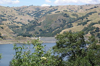
Calaveras Reservoir is located primarily in Santa Clara County, California, with a small portion and its dam in Alameda County, California. The reservoir capacity is seismically restricted, approximately 30,000 acre⋅ft (37,000,000 m3). In Spanish, Calaveras means "skulls".

Coyote Creek (Santa Clara County)

Coyote Creek is a river that flows through the Santa Clara Valley in California, United States.

Stevens Creek (California) river in the United States of America

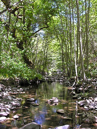
Stevens Creek is a creek in Santa Clara County, California. The creek originates in the Santa Cruz Mountains on the western flank of Black Mountain in the Monte Bello Open Space Preserve near the terminus of Page Mill Road at Skyline Boulevard. It flows southeasterly through the Stevens Creek County Park before turning northeast into Stevens Creek Reservoir. It then continues north for 12.5 miles through Cupertino, Los Altos, Sunnyvale and Mountain View before emptying into the San Francisco Bay at the Whisman Slough, near Google's main campus.

Alameda Creek river in the United States of America

Alameda Creek, originally Arroyo de la Alameda, is a large perennial stream in the San Francisco Bay Area. The creek runs for 45 miles (72 km) from a lake northeast of Packard Ridge to the eastern shore of San Francisco Bay by way of Niles Canyon and a flood control channel.

Los Gatos Creek (Santa Clara County, California) river in the United States of America

The Los Gatos Creek runs 24 miles (39 km) in California through Santa Clara Valley Water District's Guadalupe Watershed from the Santa Cruz Mountains northward through the Santa Clara Valley until its confluence with the Guadalupe River in downtown San Jose. The Guadalupe River then continues onward into San Francisco Bay.

San Leandro Creek river in the United States of America

San Leandro Creek, formerly Arroyo de San Leandro is a 21.7-mile-long (34.9 km) year-round natural stream in the Berkeley Hills, in Alameda County and Contra Costa County of the East Bay in northern California.

Redwood Creek (San Mateo County) creek in Redwood City to the San Francisco Bay

Redwood Creek is a 9.5-mile-long (15.3 km) perennial stream located in San Mateo County, California, United States which discharges into South San Francisco Bay. The Port of Redwood City, the largest deepwater port in South San Francisco Bay, is situated on the east bank of Redwood Creek near its mouth, where the creek becomes a natural deepwater channel.

Arroyo Mocho river in the United States of America

Arroyo Mocho is a 34.7-mile-long (55.8 km) stream which originates in the far northeastern corner of Santa Clara County and flows northwesterly into eastern Alameda County, California. After traversing the cities of Livermore and Pleasanton it joins South San Ramon Creek to become Arroyo de la Laguna, which in turn flows to Alameda Creek and thence to San Francisco Bay.

Upper Penitencia Creek is actually one of two creeks by the name Penitencia Creek in the northeastern Santa Clara Valley of Santa Clara County, California. They are both tributaries of Coyote Creek. The creek was diverted southwestward to Coyote Creek ca. 1850 by a farmer to irrigate his fields, permanently splitting Upper Penitencia Creek from Lower Penitencia Creek. Upper Penitencia Creek drains the western slopes of Mount Hamilton of the Diablo Range, and passes through Alum Rock Park, before ending at its confluence with Coyote Creek at Berryessa Road.

Permanente Creek river in the United States of America

Permanente Creek is a 13.3-mile-long (21.4 km) stream originating on Black Mountain in Santa Clara County, California, United States. It is the namesake for the Kaiser Permanente health maintenance organization. Named by early Spanish explorers as Arroyo Permanente or Rio Permanente because of its perennial flow, the creek descends the east flank of Black Mountain then courses north through Los Altos and Mountain View culminating in southwest San Francisco Bay historically at the Charleston Slough but now diverted via the Permanente Creek Diversion Channel to Stevens Creek and the Mountain View Slough in San Francisco Bay.

Saratoga Creek river in the United States of America

Saratoga Creek is a north-northeast flowing creek in Santa Clara County, California.

Corte Madera Creek (San Mateo County, California) river in the United States of America

Corte Madera Creek is a 7.3-mile-long (11.7 km) creek that flows north-northwest to Searsville Dam and then joins with Bear Creek to form San Francisquito Creek in California.

San Tomas Aquino Creek river in the United States of America

San Tomas Aquinas Creek, known locally as San Tomas Aquino Creek, is a 16.5-mile-long (26.6 km) stream that heads on El Sereno mountain in El Sereno Open Space Preserve in Saratoga, California in Santa Clara County, California, United States. It flows north through the cities of Saratoga, Monte Sereno, Los Gatos, Campbell, Santa Clara and San Jose before its confluence with the Guadalupe Slough in south San Francisco Bay.

Cordilleras Creek is a 3.8-mile-long (6.1 km) northward-flowing stream originating in the Pulgas Ridge Open Space Preserve in the foothills of the Santa Cruz Mountains. It forms the border between San Carlos and Redwood City in San Mateo County, California, United States before entering Smith Slough where its waters course to Steinberger Slough and thence to San Francisco Bay.

Alamitos Creek river in the United States of America

Alamitos Creek or Los Alamitos Creek is a 7.7-mile-long (12.4 km) creek in San Jose, California, which becomes the Guadalupe River when it exits Lake Almaden and joins Guadalupe Creek. Los Alamitos Creek is located in Almaden Valley and originates from the Los Capitancillos Ridge and the Santa Cruz Mountains. This creek flows through the Valley's Guadalupe Watershed, which is owned by the Santa Clara Valley Water District. The creek flows in a generally northwesterly direction after rounding the Los Capitancillos Ridge and the town of New Almaden, in the southwest corner, before ambling along the Santa Teresa Hills on northeast side of the Almaden Valley. Its environment has some relatively undisturbed areas and considerable lengths of suburban residential character. Originally called Arroyo de los Alamitos, the creek's name is derived from "little poplar", "alamo" being the Spanish word for "poplar" or "cottonwood".

San Felipe Creek is a 14 miles (23 km) stream that originates in the western Diablo Range in Santa Clara County, California. It flows south by southeast through two historic ranchos, Rancho Los Huecos and Rancho Cañada de San Felipe y Las Animas before it joins Las Animas Creek just above Anderson Reservoir. One of the nine major tributaries of Coyote Creek, the creek’s waters pass through the Santa Clara Valley and San Jose on the way to San Francisco Bay.

San Antonio Creek is a 24.4-kilometre-long (15.2 mi) northwesterly-flowing stream originating on the eastern edge of Santa Clara County just west of its border with Stanislaus County.

Arroyo Bayo river in the United States of America

Arroyo Bayo is an 8-mile-long (13 km) perennial stream which flows northwestly along Mount Hamilton Road east of Mt. Hamilton in the Diablo Range. It is part of the southern Alameda Creek watershed in Santa Clara County, California.

References

  1. 1 2 3 "Smith Creek". Geographic Names Information System . United States Geological Survey.
  2. U.S. Geological Survey. National Hydrography Dataset high-resolution flowline data. The National Map, accessed February 27, 2016
  3. Durham, David L. (2000). Durham's Place Names of the San Francisco Bay Area. Clovis, California: Word Dancer Press. p. 153.
  4. Winsor family of Milpitas, Santa Clara County
  5. Carrie stevens-Walter (1905). "Into the Mt. Hamilton Hills". Sunset Magazine. Passenger Department, Southern Pacific Company. pp. 62–64.
  6. U.S. Geological Survey. Lick Observatory Quadrangle [map]. 1:24,000. 7.5 Minute Series. Washington, D.C.
  7. Biology Study for Joseph Grant County Park, Santa Clara County, California, Earth Metrics inc, prepared for the County of Santa Clara, Report #7978, October 4, 1989
  8. "Smith Creek". Geographic Names Information System . United States Geological Survey.
  9. Leidy, R.A.; G.S. Becker; B.N. Harvey (2005). Historical distribution and current status of steelhead/rainbow trout (Oncorhynchus mykiss) in streams of the San Francisco Estuary, California (Alameda County) (Report). Oakland, California: Center for Ecosystem Management and Restoration. Retrieved 2016-02-28.
  10. John Otterbein Snyder, United States Bureau of Fisheries (1905). Notes on the fishes of the streams flowing into San Francisco Bay, California in Report of the Commissioner of Fisheries to the Secretary of Commerce and Labor for the fiscal year ending June 30, 1904. 30. General Printing Office. p. 337. Retrieved 2011-08-28.
  11. Robert A. Leidy; Gordon Becker; Brett N. Harvey (2005). Historical Distribution and Current Status of Steelhead/Rainbow Trout (Oncorhynchus mykiss) in Streams of the San Francisco Estuary, California (PDF) (Report). Center for Ecosystem Management and Restoration. p. 123. Retrieved 2011-08-28.
  12. Jerry J. Smith (1998). Steelhead and Other Fish Resources of Western Mt. Hamilton Streams (PDF) (Report). San Jose, California: San Jose State University. Retrieved 2016-03-04.
  13. Jerry J. Smith (July 25, 2013). Northern Santa Clara County Fish Resources (PDF) (Report). San Jose State University. Retrieved March 12, 2016.
  14. "Blue Oak Ranch Reserve Biodiversity". University of California. Retrieved 2012-10-20.
  15. "Hockey Meets Habitat Preservation for New County Parkland". The Nature Conservancy. November 1, 2012. Retrieved 2016-03-04.