
McGhee Tyson Airport is a public/military airport 12 miles south of Knoxville, in Alcoa, Blount County, Tennessee, United States. It is named for United States Navy pilot Charles McGhee Tyson, who was killed in World War I.
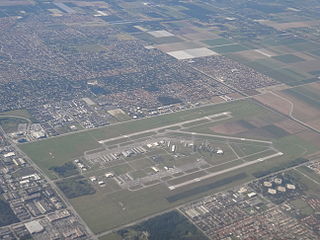
Miami Executive Airport, formerly known until 2014 as Kendall-Tamiami Executive Airport, is a public airport in unincorporated Miami-Dade County, Florida, 13 miles (21 km) southwest of Downtown Miami. It is operated by the Miami-Dade Aviation Department.

Knox County Regional Airport is a county-owned, public-use airport in the town of Owls Head, Knox County, Maine, United States. It is located three nautical miles (6 km) south of the central business district of Rockland, Maine. The airport serves the residents of midcoast Maine with commercial and charter aviation services. Scheduled airline service is subsidized by the Essential Air Service program. It is also a major hub of freight and mail service to Maine's island communities including Matinicus, North Haven and Vinalhaven.

Grant County International Airport is a public use airport in the northwest United States, located six miles (10 km) northwest of the central business district of Moses Lake in Grant County, Washington. Formerly a military facility, the airport is owned by the Port of Moses Lake, and its 13,500-foot (4,110 m) runway is the 17th longest in the U.S.

Powell, formerly known as Powell Station, is a census-designated place in Knox County, Tennessee, United States. The area is located in the Emory Road corridor, just north of Knoxville, southeast of Clinton, and east of Oak Ridge. It had a population of 13,802 during the 2020 census. It is included in the Knoxville, Tennessee Metropolitan Statistical Area.

Knoxville Downtown Island Airport or Knoxville Downtown Island Home Airport, often referred to as Island Home Airport, is a general aviation airport located approximately one-half mile east of downtown Knoxville, in Knox County, Tennessee, United States.
A STOLport or STOLPORT was an airport designed with STOL operations in mind, usually for an aircraft class of certain weight and size. The term "STOLport" did not appear to be in common usage as of 2008, although was commonly used by pilots flying into Biggin Hill during 1986/87 when the London City Airport was opened restricting approaches and ceilings to the north of Biggin. A STOLport normally had a short single runway, in general shorter than 1,500 m (5,000 ft). STOLports only accepted certain types of aircraft, often only smaller propeller aircraft, and often with limits on the amount of fuel that can be taken. In the United States, short runway facilities are simply known as airports, and the term "STOLport" has not been commonly used since the early 1970s.
Pittsburgh Northeast Airport is a privately owned, public use airport in Allegheny County, Pennsylvania, United States. The airport is located 12 nautical miles north-northeast of the central business district of Pittsburgh, in West Deer Township. The airport is located a few miles north of Pittsburgh Mills shopping mall.

Morristown Regional Airport is a city-owned public-use airport located four nautical miles southwest of the central business district of Morristown, a city in Hamblen County, Tennessee, United States. It was opened in 1953. The manager of the airport was Evelyn Bryan Johnson until her death on May 10, 2012.

Centre Municipal Airport is a city-owned, public-use airport located three nautical miles east of the central business district of Centre, a city in Cherokee County, Alabama, United States. It is owned by the City of Centre.

Courtland Airport is a public-use airport located two nautical miles northeast of the central business district of Courtland, a town in Lawrence County, Alabama, United States. It is owned by the Lawrence County Commission and was formerly known as Lawrence County Airport.
Greensboro Municipal Airport is a city-owned public-use airport located three nautical miles southwest of the central business district of Greensboro, a city in Hale County, Alabama, United States.
Parker Carson Airport is a privately owned, public use airport located five nautical miles east of the central business district of Carson City, Nevada, United States. It was formerly known as Parker Carson STOLport.
McMinn County Airport is a county-owned, public-use airport located three nautical miles (6 km) southeast of the central business district of Athens, a city in McMinn County, Tennessee, United States.
Elizabethton Municipal Airport is three miles east of Elizabethton, in Carter County, Tennessee. The National Plan of Integrated Airport Systems for 2011–2015 categorized it as a general aviation airport.

Bentonville Municipal Airport is a city-owned, public-use airport located two nautical miles (3.7 km) south of the central business district of Bentonville, a city in Benton County, Arkansas, United States. It is also known as Louise M. Thaden Field or Louise Thaden Field, a name it was given in 1951 to honor Louise McPhetridge Thaden (1905–1979), an aviation pioneer from Bentonville.
Beech River Regional Airport is a public-use airport in Henderson County, Tennessee, United States. It is located five nautical miles northwest of the central business district of Parsons, a city in Decatur County.
Edgar County Airport is a public use airport in Edgar County, Illinois, United States. It is located five nautical miles north of the central business district of Paris, Illinois. The airport is included in the FAA's National Plan of Integrated Airport Systems for 2017–2021, which categorized it as a general aviation facility.
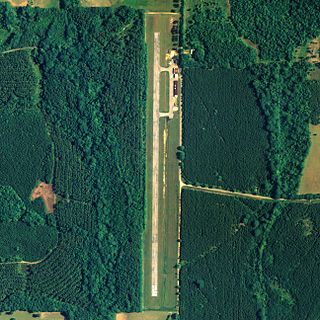
Johnson City STOLport is a privately owned, public use STOLport in Washington County, Tennessee, United States. It is located three nautical miles northeast of the central business district of Johnson City, Tennessee. This facility has a runway designed for use by STOL aircraft.
Lawrenceburg–Lawrence County Airport is a public use airport located three nautical miles (6 km) northeast of the central business district of Lawrenceburg, a city in Lawrence County, Tennessee, United States. It is owned by the City of Lawrenceburg. This airport is included in the National Plan of Integrated Airport Systems for 2011–2015, which categorized it as a general aviation facility.

