The North-West Rebellion of 1885 was a rebellion by the Métis people under Louis Riel and an associated uprising by First Nations Cree and Assiniboine of the District of Saskatchewan against the Canadian government. Many Métis felt that Canada was not protecting their rights, their land, and their survival as a distinct people.

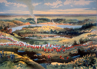
The Battle of Cut Knife, fought on May 2, 1885, occurred when a flying column of mounted police, militia, and Canadian army regular army units attacked a Cree and Assiniboine teepee settlement near Battleford, Saskatchewan. First Nations fighters forced the Canadian forces to retreat, with losses on both sides.

Meadow Lake is a city in the boreal forest of northwestern Saskatchewan, Canada. Its location is about 246 kilometres (153 mi) northeast of Lloydminster and 156 kilometres (97 mi) north of North Battleford. Founded as a trading post in 1799, it became a village in 1931 and a town in 1936. On November 9, 2009, it officially became Saskatchewan's 14th city.

Southbranch Settlement was the name ascribed to a series of French Métis settlements on the Canadian prairies in the 19th Century, in what is today the province of Saskatchewan. Métis settlers began making homes here in the 1860s and 1870s, many of them fleeing economic and social dislocation from Red River, Manitoba. The settlements became the centre of Métis resistance during the North-West Rebellion when in March 1885, Louis Riel, Gabriel Dumont, Honoré Jackson, and others set up the Provisional Government of Saskatchewan with their headquarters at Batoche.
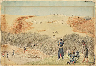
The Battle of Loon Lake concluded the North-West Rebellion on June 3, 1885 and was the last battle fought on Canadian soil. It was fought in what was then the District of Saskatchewan of the Northwest Territories, at what is now known as Steele Narrows, in Saskatchewan's Makwa Lake Provincial Park.
Cut Knife is a town located in the Canadian province of Saskatchewan on Highway 40, northwest of Saskatoon and 55 km west of North Battleford. The population of Cut Knife in 2011 was 517.
SARM Division No. 6 is a division of the Saskatchewan Association of Rural Municipalities (SARM) within the province of Saskatchewan, Canada. It is located in the north west area of the province. There are 48 rural municipalities in this division. The current spot for the Director of Division 6 is Rodney Wiens.

The Provisional Government of Saskatchewan was an independent state declared during the North-West Rebellion of 1885 in the District of Saskatchewan of the Northwest Territories. It included parts of the present-day Canadian provinces of Alberta, Saskatchewan and Manitoba. The name was given by Louis Riel. Although Riel initially hoped to rally the Countryborn, Cree and European settlers of the Saskatchewan Valley to his banner, this did not occur. The government, with the exception of Honoré Jaxon and Chief White Cap, had an entirely French-speaking and Métis leadership. Gabriel Dumont was proclaimed adjutant general in which capacity he became supreme military commander, although Riel could, and did, override his tactical decisions. The Provisional Government was declared by Riel on March 19, 1885. It ceased to exist following the defeat of the Métis militarily during the Battle of Batoche, which concluded on May 20, 1885. During its existence the government only exercised authority over the Southbranch Settlements along the South Saskatchewan River. Other major centres in the area such as Prince Albert, Saskatoon, and most First Nations reserves remained outside of its control.

St. Walburg is a town in west-central Saskatchewan's prairie region on Saskatchewan Highway 26. St. Walburg is surrounded by the Rural Municipality of Frenchman Butte No. 501. The Bronson Provincial Forest is 10 kilometres (6.2 mi) to the north.
Highway 3 is a major provincial paved undivided highway in the Canadian province of Saskatchewan. It runs from the Alberta border, where it continues west as Alberta Highway 45, to the Manitoba border, and then continues east as Highway 77. Highway 3 is about 615 km (382 mi.) long. The CanAm Highway comprises Saskatchewan Highways 35, 39, 6, 3, as well as 2. 59.7 miles (96.1 km) of Saskatchewan Highway 3 contribute to the CanAm Highway between Melfort and Prince Albert.

The Rural Municipality of Frenchman Butte No. 501 is a rural municipality (RM) in the Canadian province of Saskatchewan within Census Division No. 17 and SARM Division No. 6.
Highway 26 is a highway in the western portion of the Canadian province of Saskatchewan. The southernmost point is a junction with Highway 4, north of North Battleford. From there, it runs generally northwest, including a 29 km concurrency with Highway 3 from just north of Turtleford to just south of St. Walburg, where it turns to a more northerly route. Highway 26 continues north until it terminates at a junction with Highway 224 and Highway 950, at the northern edge of the village of Goodsoil.
Highway 40 is a highway in the northwest portion of the Canadian province of Saskatchewan connecting Alberta to Highway 3, 4 km (2.5 mi) west of Shellbrook, Saskatchewan. Areas of this highway between the Alberta border and North Battleford are called the Poundmaker Trail. Pitikwahanapiwiyin, commonly known as Poundmaker, was a Plains Cree chief known as a peacemaker and defender of his people. The main feature along this highway is access between North Battleford and near Prince Albert. This is a primary Saskatchewan highway maintained by the provincial government. All of this highway is paved.

Turtleford is a town in the rural municipality of Mervin No. 499, in the Canadian province of Saskatchewan. Turtleford is located on Highway 26 near the intersection / concurrency with Highway 3 and Highway 303. The nearest large communities are North Battleford and Lloydminster. The Turtle River runs through Turtleford, and nearby are Bright Sand Lake and Turtle Lake.

Maidstone is a town in northwest Saskatchewan, Canada located 57 km east of Lloydminster and 84 km west of North Battleford at the junction of Highway 16 and Highway 21. The community was named after Maidstone, Kent, England.
Alberta Health Services (AHS) is the single health authority for the Canadian province of Alberta.
The Looting of Battleford began at the end of March, 1885, during the North-West Rebellion, in the town of Battleford, Saskatchewan, then a part of the Northwest Territories.

The Saskatoon Health Region was the largest health region in Saskatchewan, Canada. Primarily based in the city of Saskatoon, the health region operated out of 75 facilities, including 10 hospitals, 29 long term care facilities, and numerous primary health care sites, public health centres, mental health and addictions centres, and community-based facilities. The health region was the largest employer in the province with a staff of over 13,500.
Saskatchewan Hospital North Battleford (SHNB) is a public psychiatric hospital in North Battleford, Saskatchewan. It is owned by the Government of Saskatchewan and operated by the Saskatchewan Health Authority. The facility has 284 beds in total, including a 96-bed secure unit for offenders with mental health needs. The new facility includes a number of modernizations to improve patient care, including:

The North Battleford Crown Colony is an unincorporated community within the Rural Municipality of North Battleford No. 437 in Saskatchewan, Canada that is designated a census subdivision by Statistics Canada. It is adjacent to the City of North Battleford and is home to the Saskatchewan Hospital North Battleford.