Prince Edward's Gate

Last updated

Prince Edward's Gate
Part of Fortifications of Gibraltar
Charles V Wall, Gibraltar
Prince Edward's Gate, south.png
View of Prince Edward's Gate in Charles V Wall from Europa Road, looking north.
Prince Edward's Gate, north.png
View of Prince Edward's Gate in Charles V Wall looking south from Prince Edward's Road. Sentry box to the left.
Gibraltar location map.svg
Red pog.svg
Prince Edward's Gate
Coordinates 36°08′06″N5°21′07″W / 36.134984°N 5.351841°W / 36.134984; -5.351841
Type City gate
Site information
Owner Government of Gibraltar
Open to
the public
Yes
ConditionGood
Site history
Built1790

Prince Edward's Gate is a city gate at the entrance to Prince Edward's Road in the British Overseas Territory of Gibraltar. It cuts through Charles V Wall, one of the 16th century fortifications of Gibraltar at the former southern limit of the city. The gate is adjacent to the west wall of the Flat Bastion, another 16th-century fortification. The gate was named after Prince Edward, the future Duke of Kent, and was opened in 1790, the same year the prince arrived at Gibraltar as commander of the 7th Regiment of Foot (Royal Fusiliers). While the gate now has a limited role in the defence of Gibraltar, it continues to provide vehicular and pedestrian access through Charles V Wall. Prince Edward's Gate is listed with the Gibraltar Heritage Trust.

Contents

History

Section of 1908 Ordnance Survey map of Gibraltar with Flat Bastion. North to the left. Prince Edward's Gate at lower edge of map, tucked behind orillon of west wall of bastion, next to retired flank. Flat Bastion Map 1908.png
Section of 1908 Ordnance Survey map of Gibraltar with Flat Bastion. North to the left. Prince Edward's Gate at lower edge of map, tucked behind orillon of west wall of bastion, next to retired flank.

Prince Edward's Gate (pictured at right and below) is located on Prince Edward's Road in Gibraltar, the British Overseas Territory at the southern end of the Iberian Peninsula. [1] [2] [3] The gate is in the Charles V Wall, one of the sixteenth-century fortifications of Gibraltar that formed the early southern defences of the city. [4] [5] [6] Prince Edward's Gate, which was constructed in 1790, extends from the northwest corner of the Flat Bastion, another sixteenth-century fortification which projects southward from the Charles V Wall. [7] [8] [9] The gate was positioned adjacent to the retired flank of the bastion, behind the orillon of its west wall (pictured in OS map at right), to aid in its defence. [10] [11] [12] Prince Edward's Gate overlooked Trafalgar Cemetery to the southwest and the former St. Jago's Cemetery to the northwest. [5] [7] [13]

There are two guardhouses next to the Prince Edward's Gate. [3] A plaque (link below) adjacent to the sentry box on the north side of Prince Edward's Gate indicates that it was formerly the site of an inscription: "God and the soldier all men adore in time of trouble and no more, for when war is over and all things righted God is neglected and the old soldier slighted." [14]

Prince Edward

Prince Edward, Duke of Kent Edward, Duke of Kent and Strathearn by Sir William Beechey.jpg
Prince Edward, Duke of Kent

The gate was named after Prince Edward (2 November 1767 23 January 1820), the fourth son of King George III, and later the Duke of Kent (1799) and the father of Queen Victoria (1819). [8] [15] [16] At the time that the gate was opened, in 1790, the prince (pictured at right) was serving with the military in Gibraltar, as commander of the 7th Regiment of Foot (Royal Fusiliers). [8] [16] There, he developed a reputation as a strict disciplinarian; the prince and his regiment left Gibraltar for Québec the following year, in 1791. [16] However, the Duke of Kent returned as Governor of Gibraltar in May 1802, following the death of Governor General Charles O'Hara who had died the previous February. [15] [16] General Barnett had served as acting governor in the interim. Prince Edward had orders from his brother Prince Frederick, the Duke of York, to restore a sense of military discipline at the garrison. The soldiers had become slovenly, and spent much of their time inebriated. [15] Following his closure of taverns, a mutiny broke out on Christmas Eve 1802. The mutiny and his intended murder had been planned at the Three Guns Tavern, one of only three that the new governor had not closed. The mutiny was unsuccessful but, combined with his general reputation as a harsh disciplinarian, culminated in the duke's forced departure from Gibraltar in 1803. [15] [16] [17] However, he refused to give up his position as governor, which he retained in name only. Subsequently, lieutenant governors served in Gibraltar until the duke's death in 1820. [6] [7] [15]

Legacy

Prince Edward's Gate was the subject of stamps issued by the Gibraltar Philatelic Bureau in 1971 and 1993. The issue in 1971 (link below) consisted of a pair of stamps, with two versions of the same view of the gate, one from an early nineteenth century print and the other from a twentieth-century photograph. The issue in 1993 (link below) featured an image of the north side of the gate. [18] [19] [20] Prince Edward's Gate continues to provide access through the Charles V Wall. The gate and its two adjacent guardhouses have been listed with the Gibraltar Heritage Trust. [3]

Related Research Articles

<span class="mw-page-title-main">Trafalgar Cemetery</span> Cemetery in Gibraltar

The Trafalgar Cemetery is a cemetery in the British Overseas Territory of Gibraltar. Formerly known as the Southport Ditch Cemetery, it occupies a small area of land just to the south of the city walls, in what had been a defensive ditch during the period of Spanish rule of Gibraltar. Although it is named for the Battle of Trafalgar of 21 October 1805, only two victims of the battle are buried there. The remainder of the interments are mostly of those killed in other sea battles or casualties of the yellow fever epidemics that swept Gibraltar between 1804 and 1814. In addition, tombstones were transferred to the Trafalgar Cemetery from St. Jago's Cemetery and Alameda Gardens.

<span class="mw-page-title-main">Flat Bastion Road</span> Road in Gibraltar

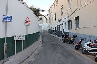
Flat Bastion Road is a road in Gibraltar, the British Overseas Territory at the southern end of the Iberian Peninsula. The road runs north–south, providing views of the city and Bay of Gibraltar. Previously known in Spanish as Senda del Moro, the traditional Llanito name for the road is Cuesta de Mr. Bourne.

<span class="mw-page-title-main">American War Memorial, Gibraltar</span>

The American War Memorial is a World War I memorial in the British Overseas Territory of Gibraltar. It was built for the American Battle Monuments Commission in 1933, and incorporated into the main city wall, the Line Wall Curtain. It commemorated the successful alliance of the United States and the United Kingdom in their naval exploits in the vicinity of Gibraltar during the Great War. The monument was inaugurated in 1937. Sixty-one years later, in November 1998, the monument was the site of another unveiling ceremony, that of a bronze plaque which commemorated the World War II Allied invasion of North Africa, Operation Torch. That unveiling ceremony was one of a number of events that weekend whose guests included dignitaries from the United Kingdom and the United States.

<span class="mw-page-title-main">Flat Bastion</span> Bastion in Gibraltar

Flat Bastion is a bastion which projects southward from the Charles V Wall in the British Overseas Territory of Gibraltar. Once known as the St. Jago's Bastion or the Baluarte de Santiago in Spanish, the fortification was built by the Spanish in the mid 16th century and formed part of the southern defences of the city of Gibraltar, together with Charles V Wall, Southport Gates, Southport Ditch, and South Bastion. In 1859, six guns, four 12-pounders and two 12-pound carronades, were installed on the bastion, and four years later, five 32-pounders were mounted on the fortification.

<span class="mw-page-title-main">Flat Bastion Magazine</span>

The Flat Bastion Magazine is a 19th-century magazine in the British Overseas Territory of Gibraltar. It is located within the Flat Bastion, a fortification that projects from the 16th century Charles V Wall at the former southern limit of the city. Flat Bastion Road extends through the bastion, just to the west of the magazine, south of which it becomes Gardiner's Road. Flat Bastion Magazine was constructed to store gunpowder, but eventually lay abandoned for years. While the Government of Gibraltar initially planned to develop it for parking, geology enthusiast Freddie Gomez and a colleague restored the building, which is now used as a geological research facility and exhibition centre. Both the Flat Bastion and the Flat Bastion Magazine are listed with the Gibraltar Heritage Trust. In addition, Gomez received the 2001 Heritage Award for the restoration of the building.

<span class="mw-page-title-main">Orillon</span>

An orillon, also known as an orillion, is an architectural element of a military fortification. The ear-shaped projection of masonry provided defense for guns and soldiers at the flank of a bastion. However, an orillon could also shield a city gate.

<span class="mw-page-title-main">Southport Gates</span>

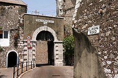
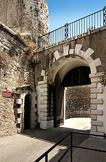
The Southport Gates are three city gates in the British Overseas Territory of Gibraltar. They are located in the Charles V Wall, one of the 16th century fortifications of Gibraltar. The gates are clustered together, with the South Bastion to the west, and the Trafalgar Cemetery to the east. The first and second Southport Gates were constructed at present day Trafalgar Road in 1552 and 1883, respectively. The third gate, Referendum Gate, is the widest of the three and was constructed in 1967 at Main Street, immediately west of the first two gates. The Southport Gates are listed with the Gibraltar Heritage Trust.

<span class="mw-page-title-main">Streets in Gibraltar</span>

Streets in the British Overseas Territory of Gibraltar are represented by road signs as in the United Kingdom. As of 2007, Gibraltar has a network of 29 kilometres (18 mi) of roads.

<span class="mw-page-title-main">Charles V Wall</span> Defensive wall in Gibraltar

The Charles V Wall is a 16th-century defensive curtain wall that forms part of the fortifications of the British Overseas Territory of Gibraltar. Originally called Muralla de San Benito, it was built in 1540 and strengthened in 1552 by Holy Roman Emperor Charles V. The wall remains largely intact and extends from South Bastion, which was once at the water's edge in the harbour, to the top ridge of the Rock of Gibraltar.

<span class="mw-page-title-main">Grand Casemates Gates</span>

Grand Casemates Gates, formerly Waterport Gate, provide an entrance from the northwest to the old, fortified portion of the city of the British Overseas Territory of Gibraltar, at Grand Casemates Square.

<span class="mw-page-title-main">South Bastion, Gibraltar</span> Bastion in Gibraltar

The South Bastion was part of the fortifications of Gibraltar, protecting the western base of the Charles V Wall. It was originally built by Spanish military engineers, later improved by the British. The South Bastion stands at the south end of the Line Wall Curtain which defends the town from attack from the Bay of Gibraltar. Another curtain wall runs east from the bastion to the base of a precipice. This wall is pierced by the Southport Gates, guarded by the South Bastion and the Flat Bastion on either side.

<span class="mw-page-title-main">O'Hara's Battery</span> Artillery battery in Gibraltar

O'Hara's Battery is an artillery battery in the British Overseas Territory of Gibraltar. It is located at the highest point of the Rock of Gibraltar, near the southern end of the Upper Rock Nature Reserve, in close proximity to Lord Airey's Battery. It was constructed in 1890 at the former site of a watchtower that had earned the name O'Hara's Folly. The battery and tower were both named after the Governor of Gibraltar Charles O'Hara. The first gun mounted on the battery was a 6-inch breech loading gun, which was replaced with a 9.2 inch Mark X BL gun in 1901. The battery was in use during World War II and was last fired during training exercises in 1976. O'Hara's Battery has been refurbished and is open to the public. The battery and its associated works are listed with the Gibraltar Heritage Trust.

<span class="mw-page-title-main">North Bastion, Gibraltar</span>

The North Bastion, formerly the Baluarte San Pablo was part of the fortifications of Gibraltar, in the north of the peninsula, protecting the town against attack from the mainland of Spain. The bastion was based on the older Giralda tower, built in 1309. The bastion, with a mole that extended into the Bay of Gibraltar to the west and a curtain wall stretching to the Rock of Gibraltar on its east, was a key element in the defenses of the peninsula. After the British took Gibraltar in 1704 they further strengthened these fortifications, flooding the land in front and turning the curtain wall into the Grand Battery.

<span class="mw-page-title-main">Sir William Green, 1st Baronet</span> British army officer

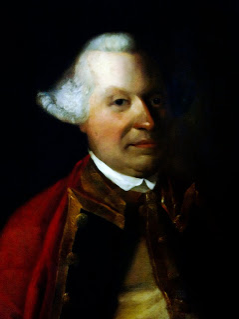
General Sir William Green, 1st Baronet, of Marass, Kent was an officer in the British Army.

<span class="mw-page-title-main">Montagu Bastion</span>

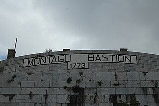
The Montagu Bastion is one of many bastions which were designed to protect Gibraltar. Montagu was joined to Orange Bastion by a curtain wall known as Montagu Curtain and this bastion was protected by the Montagu Counterguard.

<span class="mw-page-title-main">Orange Bastion</span>

The Orange Bastion is one of the many bastions in the British Overseas Territory of Gibraltar, which served to protect it against its many sieges. It is located along the Line Wall Curtain and was built to protect Gibraltar Harbour against enemy attack.

<span class="mw-page-title-main">King's Bastion</span>

King's Bastion is a coastal bastion on the western front of the fortifications of the British overseas territory of Gibraltar, protruding from the Line Wall Curtain. It is located between Line Wall Road and Queensway and overlooks the Bay of Gibraltar. It played a crucial role in defending The Rock during the Great Siege of Gibraltar. In more recent history the bastion was converted into a generating station which powered Gibraltar's electricity needs. Today it continues to serve the community as Gibraltar's leisure centre.

<span class="mw-page-title-main">Hesse's Demi Bastion</span>

Hesse's Demi Bastion is a demi-bastion in the British Overseas Territory of Gibraltar. It is part of the Northern Defences of Gibraltar. The bastion forms a link in a chain of fortifications which ascend the lower north-west slopes of the Rock of Gibraltar, below the King's Lines Battery and Bombproof Battery. The Moorish Castle's Tower of Homage is at the top of the same incline.

<span class="mw-page-title-main">Fortifications of Gibraltar</span> Defensive military constructions at the Rock of Gibraltar

The Gibraltar peninsula, located at the far southern end of Iberia, has great strategic importance as a result of its position by the Strait of Gibraltar where the Mediterranean Sea meets the Atlantic Ocean. It has repeatedly been contested between European and North African powers and has endured fourteen sieges since it was first settled in the 11th century. The peninsula's occupants – Moors, Spanish, and British – have built successive layers of fortifications and defences including walls, bastions, casemates, gun batteries, magazines, tunnels and galleries. At their peak in 1865, the fortifications housed around 681 guns mounted in 110 batteries and positions, guarding all land and sea approaches to Gibraltar. The fortifications continued to be in military use until as late as the 1970s and by the time tunnelling ceased in the late 1960s, over 34 miles (55 km) of galleries had been dug in an area of only 2.6 square miles (6.7 km2).

References

  1. "List of Crown Dependencies & Overseas Territories". fco.gov.uk. Foreign and Commonwealth Office . Retrieved 28 September 2012.
  2. Roach, John (13 September 2006). "Neandertals' Last Stand Was in Gibraltar, Study Suggests". National Geographic News. National Geographic Society. Archived from the original on 14 November 2006. Retrieved 28 September 2012.
  3. 1 2 3 "Gibraltar Heritage Trust Act 1989" (PDF). gibraltarlaw.gov.gi. Government of Gibraltar. Archived from the original (PDF) on 27 August 2012. Retrieved 29 September 2012.
  4. "Historical Gibraltar Attractions - Charles V Wall". gibraltarinformation.com. Archived from the original on 29 August 2012. Retrieved 29 September 2012.
  5. 1 2 "Gates & Fortifications". aboutourrock.com. About Our Rock. Archived from the original on 1 November 2012. Retrieved 28 September 2012.
  6. 1 2 "Gates, Walls & Fortifications". Gibraltar Discover Pocket Guide. Discover Pocket Guide(s) Gibraltar Ltd: 30. July 2009. Retrieved 29 September 2012.
  7. 1 2 3 "Historical Gibraltar Attractions (continued)". gibraltarinformation.com. Archived from the original on 26 February 2012. Retrieved 28 September 2012.
  8. 1 2 3 "Flat Bastion, Flat Bastion Magazine". discovergibraltar.com. DiscoverGibraltar.com (Click Fortifications, City Walls and Fortifications, Section 3, L Flat Bastion). Archived from the original on 5 September 2013. Retrieved 28 September 2012.
  9. Bethune, John Drinkwater (1786). A history of the late siege of Gibraltar, by John Drinkwater (2 ed.). pp. 27–28. Retrieved 29 September 2012.
  10. Clive Finlayson, Darren Fa (31 October 2006). The Fortifications of Gibraltar 1068-1945 (illustrated ed.). Osprey Publishing. p. 19. ISBN   9781846030161 . Retrieved 28 September 2012.
  11. Clive Finlayson, Darren Fa (31 October 2006). The Fortifications of Gibraltar 1068-1945 (illustrated ed.). Osprey Publishing. p. 56. ISBN   9781846030161 . Retrieved 28 September 2012.
  12. James, Thomas (1771). The history of the Herculean Straits: now called the Straits of Gibraltar: including those ports of Spain and Barbary that lie contiguous thereto. Illustrated with several copper plates, Volume 2. Printed by C. Rivington for the author. p. 307. Retrieved 29 September 2012.
  13. "Trafalgar Cemetery". Gibraltar Heritage Trust. Archived from the original on 6 February 2007. Retrieved 29 September 2012.{{cite web}}: CS1 maint: unfit URL (link)
  14. "Prince Edwards Gates Plaque". Brit on the Rock. Retrieved 28 September 2012.
  15. 1 2 3 4 5 Musteen, Jason R. (15 October 2011). "Chapter 5 - A Royal Mess". Nelson's Refuge: Gibraltar in the Age of Napoleon. Naval Institute Press. ISBN   9781612510842 . Retrieved 29 September 2012.
  16. 1 2 3 4 5 MacNutt, W.S. (1983). "Edward Augustus, Duke of Kent and Strathearn". In Halpenny, Francess G (ed.). Dictionary of Canadian Biography . Vol. V (1801–1820) (online ed.). University of Toronto Press. Retrieved 29 September 2012.
  17. Rigg, James McMullen (1892). "Kent and Strathern, Edward Augustus"  . In Lee, Sidney (ed.). Dictionary of National Biography . Vol. 31. London: Smith, Elder & Co. pp. 19–20.
  18. "Stamp Detail - 1971". poppe-stamps.com. Poppe - Stamps. Retrieved 29 September 2012.
  19. "Stamp Detail - 1993". poppe-stamps.com. Poppe-Stamps. Retrieved 29 September 2012.
  20. "Gibraltar 1993 - SG706, £1 Prince Edward's Gate, VFU". Woolieback Collectables. Archived from the original on 4 March 2016. Retrieved 28 September 2012.