Prince Edward Island Route 153

Last updated

PEI Highway 153.svg

Route 153
Major junctions
FromPEI Highway 14.svg Route 14
ToPEI Highway 152.svg Route 152
Highway system
Provincial highways in Prince Edward Island

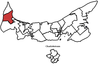
Greenmount Road, labelled Route 153, is a 2-lane collector highway [1] in western Prince County, Prince Edward Island, Canada. It is between the communities of Tignish and Alberton. Its maximum speed limit is 90 km/h (56 mph). The road is considered part of two larger communities, Tignish and Alberton.

Prince County, Prince Edward Island Place

Prince County is located in western Prince Edward Island, Canada. The county's defining geographic feature is Malpeque Bay, a sub-basin of the Gulf of St. Lawrence, which creates the narrowest portion of Prince Edward Island's landmass, an isthmus upon which the city of Summerside is located.

Prince Edward Island Province of Canada

Prince Edward Island is a province of Canada consisting of the Atlantic island of the same name along with several much smaller islands nearby. PEI is one of the three Maritime Provinces. It is the smallest province of Canada in both land area and population, but it is the most densely populated. Part of the traditional lands of the Mi'kmaq, it became a British colony in the 1700s and was federated into Canada as a province in 1873. Its capital is Charlottetown. According to the 2016 census, the province of PEI has 142,907 residents.

Canada Country in North America

Canada is a country in the northern part of North America. Its ten provinces and three territories extend from the Atlantic to the Pacific and northward into the Arctic Ocean, covering 9.98 million square kilometres, making it the world's second-largest country by total area. Canada's southern border with the United States, stretching some 8,891 kilometres (5,525 mi), is the world's longest bi-national land border. Its capital is Ottawa, and its three largest metropolitan areas are Toronto, Montreal, and Vancouver. As a whole, Canada is sparsely populated, the majority of its land area being dominated by forest and tundra. Consequently, its population is highly urbanized, with over 80 percent of its inhabitants concentrated in large and medium-sized cities, with 70% of citizens residing within 100 kilometres (62 mi) of the southern border. Canada's climate varies widely across its vast area, ranging from arctic weather in the north, to hot summers in the southern regions, with four distinct seasons.

Contents

The highway runs from Route 14 (North Cape Coastal) in Tignish, [2] to Route 152 (Union Rd) in Montrose, [3] passing through the communities of Tignish, St. Felix, Greenmount, and Montrose.

Route 14 is a two-lane, uncontrolled-access, secondary highway in western Prince Edward Island. The route is entirely in Prince County and generally parallels Route 2 as it heads toward the North Cape. Its southern terminus is at Route 2 in Coleman and its northern terminus is at Route 2 in Tignish.

Tignish, Prince Edward Island Town in Prince Edward Island, Canada

Tignish is a Canadian town located in Prince County, Prince Edward Island.

St. Felix is a municipality that holds community status in Prince Edward Island, Canada. It is located in Prince County, 4 km (2.5 mi) south of Tignish.

History

Route 153 (Greenmount Road) spans approximately 6 miles from Tignish to Montrose. The entire road was paved in the 1980s. It is home to the Greenmount Cemetery, the St. Felix Community Center, and the St. Felix Golf Course. Sections on Route 153 north of Haywood Road intersection are considered part of the Tignish community, and sections south of here are part of Alberton area.

Other information

Addresses on Route 153 south of Route 162 (O'Rourke Road) intersection receive electrical power from the St. Louis/Bloomfield power substation. Addresses north of here receive from Tignish/Elmsdale. Basic cable service from Eastlink has been available from civic numbers 8001600 Greenmount Road since 1995. High speed internet from Aliant Telecom has been available from civic numbers 12001600 since 2004.

List of roads merging off Route 153

Coordinates: 46°53′17″N64°02′52″W / 46.888°N 64.0479°W / 46.888; -64.0479

Geographic coordinate system Coordinate system

A geographic coordinate system is a coordinate system that enables every location on Earth to be specified by a set of numbers, letters or symbols. The coordinates are often chosen such that one of the numbers represents a vertical position and two or three of the numbers represent a horizontal position; alternatively, a geographic position may be expressed in a combined three-dimensional Cartesian vector. A common choice of coordinates is latitude, longitude and elevation. To specify a location on a plane requires a map projection.

Related Research Articles

Route 158, officially named Harper Road, and sometimes referred to sectionally as Leoville Road(see below), is a 2-lane collector highway in western Prince County, Prince Edward Island, Canada. It is located 0–4 miles SW of the community of Tignish. Its maximum speed limit is 80 km/h (50 mph).

Lot 1, Prince Edward Island Township in Prince Edward Island, Canada

Lot 1 is a township in Prince County, Prince Edward Island, Canada created during the 1764–1766 survey of Samuel Holland. It is part of North Parish.

Lot 2, Prince Edward Island Township in Prince Edward Island, Canada

Lot 2 is a township in Prince County, Prince Edward Island, Canada created during the 1764–1766 survey of Samuel Holland. It is part of North Parish.

Lot 4, Prince Edward Island Township in Prince Edward Island, Canada

Lot 4 is a township in Prince County, Prince Edward Island, Canada created during the 1764–1766 survey of Samuel Holland. It is part of Egmont Parish.

Alberton, Prince Edward Island Town in Prince Edward Island, Canada

Alberton is a Canadian town located in Prince County, Prince Edward Island. It is situated in the western part of the county in the township of Lot 5. The population was 1,149 as of the 2016 census.

Palmer Road is a small community located in Lot 1, in Prince County, Prince Edward Island, Canada that is located on Route 155, Route 156 and Route 158. There are approximately 100 citizens in Palmer Road, and it is located between the two towns of Tignish and St. Louis, Prince Edward Island. It is also home to the Immaculate Conception Church, and the nearby Palmer Road Community Center. Palmer Road is located 2 mi (3.2 km) northwest of St. Louis, and 6 mi (9.7 km) southwest of Tignish.

St. Simon & St. Jude Church (Tignish) Church in Prince Edward Island, Canada

St. Simon & St. Jude Church, known colloquially as Tignish Church is a 19th-century Roman Catholic church located in Tignish parish, Prince Edward Island, Canada. As of 2006, it is the single largest church on Prince Edward Island, measuring 185 feet high. It can be clearly seen for 6 miles on flat land, and for many more miles at sea. It is perhaps most famous for its widely publicized apparition of Jesus event.

Miminegash, Prince Edward Island human settlement in Prince Edward Island, Canada

Miminegash is a municipality that holds community status in Prince Edward Island, Canada. It is located 8 miles (13 km) northwest of Alberton and 11 miles (18 km) southwest of Tignish. It is part of a small area known as either the St. Louis, Palmer Road, or Miminegash area. This area is often associated with Tignish due to the shared Acadian roots between these areas.

Harper, Prince Edward Island human settlement in Prince County, Prince Edward Island, Canada

Harper is a Canadian rural community located in western Prince County, Prince Edward Island.

Ascension Road, labelled Route 160, is a 2-lane collector highway in western Prince County, Prince Edward Island, Canada. It is located 2 miles (3.2 km) NW of the community of Tignish. Its maximum speed limit is 80 kilometres per hour (50 mph).

Peter Road, or Peterville Road, labelled Route 159, is a 2-lane collector highway in western Prince County, Prince Edward Island, Canada. It is near the community of Tignish. Its maximum speed limit is 80 km/h (50 mph).

Pridham Road, labelled Route 154, is a 2-lane collector highway in western Prince County, Prince Edward Island, Canada. It is near the town of Alberton. Its maximum speed limit is 80 km/h (50 mph).

Prince Edward Island Route 156 highway in Prince Edward Island

Palmer Road, labelled Route 156, is a 2-lane collector highway in western Prince County, Prince Edward Island, Canada. It is between the communities of Tignish and Miminegash. Its maximum speed limit is 80 km/h (50 mph). The road is considered part of two larger communities, Tignish and Miminegash.

Ellerslie Road, labelled Route 133, is a 2-lane collector highway in Prince County, Prince Edward Island, Canada. It is located 2.5–5 miles NE of the community of Tyne Valley and is located within the community of Ellerslie. Its maximum speed limit is 80 km/h (50 mph).

Alberton-Roseville Provincial electoral district in Prince Edward Island

Alberton-Roseville was a provincial electoral district for the Legislative Assembly of Prince Edward Island, Canada. It was formerly known as Alberton-Miminegash from 1996 to 2007.

Tignish-Palmer Road Provincial electoral district in Prince Edward Island

Tignish-Palmer Road is a provincial electoral district for the Legislative Assembly of Prince Edward Island, Canada. It was formerly Tignish-DeBlois from 1996 to 2007.

St. Louis, Prince Edward Island Community in Prince Edward Island, Canada

St. Louis is a municipality that holds community status in Prince Edward Island, Canada.

Prince Edward Island Route 142, known locally as O'Leary Road, is a 2-lane highway in Prince County, Prince Edward Island, Canada. The highway bisects the island approximately halfway between Summerside and Tignish, and passes through the town of O'Leary.

References

  1. Chapter R-15, Roads Act: Highway Access Regulations,  20 September 2016. Retrieved on 26 November 2016.
  2. Prince Edward Island Provincial Road Atlas (PDF) (Map) (2014 ed.). Government of Prince Edward Island. Retrieved 26 November 2016.
  3. Chapter R-15, Roads Act: Vehicle Weights and Dimensions Regulations,  15 December 2010. Retrieved on 26 November 2016.