
The Trans-Canada Highway is a transcontinental federal–provincial highway system that travels through all ten provinces of Canada, from the Pacific Ocean on the west coast to the Atlantic Ocean on the east coast. The main route spans 7,476 km (4,645 mi) across the country, one of the longest routes of its type in the world. The highway system is recognizable by its distinctive white-on-green maple leaf route markers, although there are small variations in the markers in some provinces.

The Princes Highway is a major road in Australia, extending from Sydney to Adelaide via the coast through the states of New South Wales, Victoria and South Australia. It has a length of 1,941 kilometres (1,206 mi) or 1,898 kilometres (1,179 mi) via the former alignments of the highway, although these routes are slower and connections to the bypassed sections of the original route are poor in many cases.
Highway 17 is a provincial highway in British Columbia, Canada. It comprises two separate sections connected by a ferry link. The Vancouver Island section is known as the Patricia Bay Highway and connects Victoria to the Swartz Bay ferry terminal in North Saanich. The Lower Mainland section is known as the South Fraser Perimeter Road and connects the Tsawwassen ferry terminal to Delta and Surrey, terminating at an interchange with Highway 1 in the Fraser Valley.
Maryland Route 2 is the longest state highway in the U.S. state of Maryland. The 79.24-mile (127.52 km) route runs from Solomons Island in Calvert County north to an intersection with U.S. Route 1 /US 40 Truck in Baltimore. The route runs concurrent with MD 4 through much of Calvert County along a four-lane divided highway known as Solomons Island Road, passing through rural areas as well as the communities of Lusby, Port Republic, Prince Frederick, and Huntingtown. In Sunderland, MD 2 splits from MD 4 and continues north as two-lane undivided Solomons Island Road into Anne Arundel County, still passing through rural areas. Upon reaching Annapolis, the route runs concurrent with US 50/US 301 to the north the city. Between Annapolis and Baltimore, MD 2 runs along the Governor Ritchie Highway, a multilane divided highway that heads through suburban areas, passing through Arnold, Severna Park, Pasadena, Glen Burnie, and Brooklyn Park. In Baltimore, the route heads north on city streets and passes through the downtown area of the city.

Tonkin Highway is an 81-kilometre-long (50 mi) north–south highway and partial freeway in Perth, Western Australia, linking Perth Airport and Kewdale with the city's north-eastern and south-eastern suburbs. As of April 2020, the northern terminus is at the interchange with Brand Highway and Great Northern Highway in Muchea, and the southern terminus is at Thomas Road in Oakford. It forms the entire length of State Route 4, and connects to several major roads. Besides Brand Highway and Great Northern Highway, it also connects to Reid Highway, Great Eastern Highway, Leach Highway, Roe Highway, and Albany Highway.
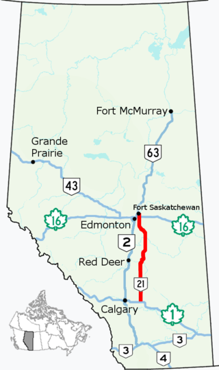
Alberta Provincial Highway No. 21, commonly referred to as Highway 21, is a north–south highway in Alberta, Canada that parallels Highway 2 between Calgary and Edmonton. It is approximately 328 kilometres (204 mi) in length. It begins at the Trans-Canada Highway (Highway 1) east of Strathmore, and ends at Fort Saskatchewan where it is succeeded by Highway 15. The northernmost 25 kilometres (16 mi) of the highway are twinned. Highway 21 runs roughly parallel to the main north–south CN rail line between Calgary and Edmonton between Three Hills and Looma.

State Highway 1 is the longest and most significant road in the New Zealand road network, running the length of both main islands. It appears on road maps as SH 1 and on road signs as a white number 1 on a red shield, but it has the official designations SH 1N in the North Island, SH 1S in the South Island.
Route 1 is a 120-kilometre (75 mi) long provincial highway that serves as the Prince Edward Island section of the Trans-Canada Highway. Route 1 traverses the southern shores of Prince Edward Island, from the Confederation Bridge in Borden-Carleton to the Wood Islands ferry dock, and bypasses the provincial capital, Charlottetown. It is an uncontrolled access 2-lane highway with a maximum speed limit of 90 km/h (55 mph), except within towns and urban areas.
King's Highway 31, commonly referred to as Highway 31 and historically known as the Metcalfe Road, was a provincially maintained highway in the Canadian province of Ontario. The 76.93-kilometre (47.80 mi) route connected Highway 2 in Morrisburg with the Chaudière Bridge at the Ontario–Quebec boundary in downtown Ottawa.

Route 4 is a 63 km (39 mi) long, two-lane uncontrolled access secondary highway in eastern Prince Edward Island, Canada. In runs east from the Trans-Canada Highway (Route 1) at Wood Islands along the Northumberland Straight to Route 18 the settlement of High Bank, where it turns north and passes through Murray River and Montague before ending at Route 2 at Dingwells Mills. Its maximum speed limit is 90 km/h (56 mph).
King's Highway 41, commonly referred to as Highway 41, is a provincially maintained highway in the Canadian province of Ontario. The 159.6-kilometre (99.2 mi) highway travels in a predominantly north–south direction across eastern Ontario, from Highway 7 in Kaladar to Highway 148 in Pembroke. The majority of this distance crosses through a rugged forested region known as Mazinaw Country. However, the route enters the agricultural Ottawa Valley near Dacre. A significant portion of Highway 41 follows the historic Addington Colonization Road, built in 1854.
King's Highway 49, commonly referred to as Highway 49, is a provincially maintained highway in the Canadian province of Ontario. The 5.8-kilometre (3.6 mi) highway travels across the Quinte Skyway and through the Tyendinaga Mohawk Territory south of Marysville.
King's Highway 7A, commonly referred to as Highway 7A, is a provincially maintained highway in the Canadian province of Ontario that serves as a bypass of Highway 7. The highway begins in the community of Manchester, where Highway 7 is concurrent with Highway 12, and travels east through Port Perry, Nestleton Station, Bethany and Cavan, ending at Highway 115 southwest of Peterborough. From there, Highway 7 can be reached via Highway 115 northbound. Near its midpoint the route is concurrent with Highway 35 for 1.5 kilometres (0.93 mi).

South Carolina Highway 170 (SC 170) is a 49.010-mile (78.874 km) state highway, connecting northern Beaufort County with southern portions of Beaufort and Jasper counties. Due to increased population growth in both areas, the majority of the road is four lanes wide, with certain areas retaining the original two-lane configuration.
Route 915 is a 30.6-kilometre (19.0 mi) long provincial highway located entirely in Albert County, New Brunswick, Canada. The highway begins at Route 114 in Alma and travels along the northwestern shores of the Bay of Fundy before turning back north to end at Route 114 in south Riverside-Albert.
Route 690 is a 45.6-kilometre (28.3 mi) long mostly north–south secondary highway in the southwestern portion of New Brunswick, Canada. Most of the route is in Canning Parish.
Prince Edward Island Route 15 is a secondary highway in central Prince Edward Island.
Route 11 is a 65.5 km (40.7 mi), two-lane, uncontrolled-access, secondary highway in western Prince Edward Island, Canada. Its southern terminus is at Route 1A in Summerside and its northern terminus is at Route 2 in Lady Slipper.
Route 16 is a 75 km (47 mi), two-lane, uncontrolled-access, secondary highway in eastern Prince Edward Island. Its eastern terminus is at Route 2 and Macphee Avenue in Souris and its western terminus is at Route 313 in Saint Peters Bay. The route is entirely in Kings County.
Route 10, also known as the eastern portion of the Irish Loop Drive and the Southern Shore Highway, is a 173-kilometre (107 mi) uncontrolled-access highway in Newfoundland and Labrador. Its southern terminus is at Route 90 in St. Vincent's-St. Stephen's-Peter's River, and its northern terminus is at Route 2 and The Parkway in St. John's. The route is in Division No. 1 and winds along the southern and eastern coasts of Avalon Peninsula on the island of Newfoundland.

