
The Northumberland Strait is a strait in the southern part of the Gulf of Saint Lawrence in eastern Canada. The strait is formed by Prince Edward Island and the gulf's eastern, southern, and western shores.

The Princes Highway is a major road in Australia, extending from Sydney to Adelaide via the coast through the states of New South Wales, Victoria and South Australia. It has a length of 1,941 kilometres (1,206 mi) or 1,898 kilometres (1,179 mi) via the former alignments of the highway, although these routes are slower and connections to the bypassed sections of the original route are poor in many cases.

Queens County is a county in the province of Prince Edward Island, Canada. It is the largest county in the province by population with 82,017 (2016), land area, and highest average income. Charlottetown is the county seat of Queens County, and is the largest city and the capital of Prince Edward Island.
Highway 17 is a provincial highway in British Columbia, Canada. It comprises two separate highways connected by a ferry link. The Vancouver Island section is known as the Patricia Bay Highway and connects Victoria to the Swartz Bay ferry terminal in North Saanich. The Lower Mainland section is known as the South Fraser Perimeter Road and connects the Tsawwassen ferry terminal to Delta and Surrey.
Highway 97 is the longest continuously numbered route in the Canadian province of British Columbia, running 2,081 km (1,293 mi) from the Canada–United States border near Osoyoos in the south to the British Columbia/Yukon boundary in the north at Watson Lake, Yukon. The route takes its number from U.S. Route 97, with which it connects at the international border. The highway was initially designated '97' in 1953.
Route 1 is a 120-kilometre (75 mi) long provincial highway that serves as the Prince Edward Island section of the Trans-Canada Highway. Route 1 traverses the southern shores of Prince Edward Island, from the Confederation Bridge in Borden-Carleton to the Wood Islands ferry dock, and bypasses the provincial capital, Charlottetown. It is an uncontrolled access 2-lane highway with a maximum speed limit of 90 km/h (55 mph), except within towns and urban areas.

Route 2, also known as Veterans Memorial Highway and the All Weather Highway, is a 216-kilometre (134 mi) two-lane uncontrolled access highway traversing Prince Edward Island, Canada from Tignish to Souris. Route 2 was recognized as the first numbered highway in the province in 1890, when it opened between Charlottetown and Summerside.
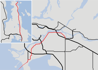
Route 3 is a 33 km (21 mi) long, two-lane uncontrolled access secondary highway in Prince Edward Island, Canada. Its maximum speed limit is 90 km/h (55 mph).

Route 4 is a 63 km (39 mi) long, two-lane uncontrolled access secondary highway in eastern Prince Edward Island, Canada. In runs east from the Trans-Canada Highway (Route 1) at Wood Islands along the Northumberland Straight to Route 18 the settlement of High Bank, where it turns north and passes through Murray River and Montague before ending at Route 2 at Dingwells Mills. Its maximum speed limit is 90 km/h (56 mph).
King's Highway 49, commonly referred to as Highway 49, is a provincially maintained highway in the Canadian province of Ontario. The 5.8-kilometre (3.6 mi) highway travels across the Quinte Skyway and through the Tyendinaga Mohawk Territory south of Marysville.

Route 13 is a 39 km (24 mi) two-lane uncontrolled access secondary highway traversing the central portion of Prince Edward Island, Canada in a more or less north–south direction between Crapaud and Cavendish. It passes through a mainly rural area of Prince Edward Island. A portion of Route 13 is commonly called the "Hopalong Road."
Prince Edward Island Route 248 is a 13.9-kilometre (8.6 mi) long north–south collector highway and local road in Queens County, Prince Edward Island. Route 248 begins at an intersection with Route 27 in the community of Cornwall just east of Route 19. The route parallels MacEwens Creek and the North River through farms and suburbs northeast of Cornwall into the village of Miltonvale Park, where it terminates at a junction with Route 2. The route also serves as the main road through the community of Warren Grove.

Prince Edward Island Route 6 is a secondary highway in central Prince Edward Island.

Prince Edward Island Route 7 is a secondary highway in central Prince Edward Island. The short connecting route begins at an intersection with Route 2 west of Charlottetown, and runs north to Oyster Bed Bridge, where the road continues as Route 6. It is an uncontrolled, paved two-lane road for its entire length.
Old Princetown Road is an historic colonial road in the Canadian province of Prince Edward Island. Dating to at least 1771, the approximately 59-kilometre (37 mi) road was an important inland commercial and military route connecting the town of Princetown or Malpeque with the colonial capital at Charlottetown. A large part of the former road is now in use as Route 2 between Charlottetown and Hunter River, while other parts remain as gravel roads or dirt paths, and some portions have been replaced entirely by farmland. A short section near South Granville is listed on the Canadian Register of Historic Places.
Route 16 is a 75 km (47 mi), two-lane, uncontrolled-access, secondary highway in eastern Prince Edward Island. Its eastern terminus is at Route 2 and Macphee Avenue in Souris and its western terminus is at Route 313 in Saint Peters Bay. The route is entirely in Kings County.
Route 18, also known as Cape Bear Road, is a 23.9 kilometres (14.9 mi), two-lane, uncontrolled-access, secondary highway in eastern Prince Edward Island. Its southern terminus is at Route 4 in High Bank and its northern terminus is at Route 4 in Murray River. The route is entirely in Kings County.
Route 25 is a 18-kilometre (11 mi), two-lane, uncontrolled-access, secondary highway in central Prince Edward Island. Its southern terminus is at Route 2 in Marshfield, and its northern terminus is at Gulf Shore Parkway East in Stanhope by the Sea. The route is entirely in Queens County.
