Arunachal Pradesh is a state in northeast India. It was formed from the North-East Frontier Agency (NEFA) region, and India declared it as a state on 20 February 1987. Itanagar is its capital and largest town. It borders the Indian states of Assam and Nagaland to the south. It shares international borders with Bhutan in the west, Myanmar in the east, and a disputed 1,129 km border with China's Tibet Autonomous Region in the north at the McMahon Line. Arunachal Pradesh is claimed by China as part of the Tibet Autonomous Region; China occupied some regions of Arunachal Pradesh in 1962 but later withdrew its forces.

Tawang district is the smallest of the 26 administrative districts of Arunachal Pradesh state in northeastern India. With a population of 49,977, it is the eighth least populous district in the country.

West Kameng is a district of Arunachal Pradesh in northeastern India. It accounts for 8.86% of the total area of the state. The name is derived from the Kameng river, a tributary of the Brahmaputra, that flows through the district.

The Border Roads Organisation (BRO) is a statutory body under the ownership of the Ministry of Defence of the Government of India. BRO develops and maintains road networks in India's border areas and friendly neighboring countries. This includes infrastructure operations in 19 states and three union territories and neighboring countries such as Afghanistan, Bhutan, Myanmar, Tajikistan and Sri Lanka. By 2022, BRO had constructed over 55,000 kilometres (34,000 mi) of roads, over 450 permanent bridges with a total length of over 44,000 metres (27 mi) length and 19 airfields in strategic locations. BRO is also tasked with maintaining this infrastructure including operations such as snow clearance.

Tawang is a town and administrative headquarter of Tawang district in the Indian state of Arunachal Pradesh. It lies on NH-13 section of Trans-Arunachal Highway. The town was once the headquarter of the Tawang Tract, which is now divided into the Tawang district and the West Kameng district. Tawang continues as the headquarters of the former. Tawang is the number one tourist destination of Arunachal Pradesh.
The Kameng River in the eastern Himalayan mountains, originates in Tawang district from the glacial lake below snow-capped Gori Chen mountain 27°48′36″N92°26′38″E, elevation 6,300 metres (20,669 ft), on the India-Tibet border and flows through Bhalukpong circle of West Kameng District, Arunachal Pradesh and Sonitpur District of Assam, India. It becomes a braided river in its lower reaches and is one of the major tributaries of the Brahmaputra River, joining it at Tezpur, just east of the Kolia Bhomora Setu bridge.

Himank, also known as Project HIMANK is a project of the Border Roads Organisation under the Ministry of Defence of India. It was established in August 1985 to facilitate the construction of road infrastructure in Ladakh and parts of Jammu and Kashmir under the India–China Border Roads project. The project is also involved in providing all year access to military bases and outposts in Siachen glacier, along the Line of actual control and areas near the Pangong Tso lake.
The Trans-Arunachal Highway (TAH), which includes an existing 1,811 km (1,125 mi) route comprising NH-13 and parts of NH-15, NH-215 and SH-25, is an under-construction 2-lane more than 2,407 km (1,496 mi) long highway passing through 16 districts in Arunachal Pradesh state in India. It runs from LAC in Tawang in northwest to Kanubari in southeast at tri-junction of Assam-Nagaland-Arunachal Pradesh. It connects at least 16 districts of Arunachal Pradesh.

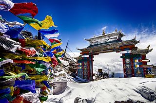
The Sela Pass is a high-altitude mountain pass located on the border between the Tawang and West Kameng districts in the Indian state of Arunachal Pradesh. It has an elevation of 4170 m (13,700 ft) and connects the Indian Buddhist town of Tawang to Dirang and Guwahati. The pass carries the National Highway 13, connecting Tawang with the rest of India. The pass supports scarce amounts of vegetation and is usually snow-covered to some extent throughout the year. Sela Lake, near the summit of the pass, is one of approximately 101 lakes in the area that are sacred in Tibetan Buddhism. While Sela Pass does get heavy snowfall in winters, it is usually open throughout the year unless landslides or snow require the pass to be shut down temporarily. Sela pass is one of the highest motorable mountain passes in the world

Pema Khandu is an Indian politician and the Chief Minister of Arunachal Pradesh. He is the son of former Chief Minister of Arunachal Pradesh Dorjee Khandu. Since assuming the office of the Chief Minister in July 2016, he and his government have twice changed their party affiliation; in September from the Indian National Congress to the Peoples Party of Arunachal, and then in December 2016 to the Bharatiya Janata Party. Previously he had served as Minister of Tourism, Urban Development and Water Resources in Nabam Tuki's government.

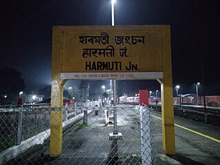
The Rangiya-Murkongselek section is a 450 km (280 mi) long railway line connecting Rangiya in Kamrup district with Murkongselek in Dhemaji district in the Indian state of Assam. The entire section is under the jurisdiction of Northeast Frontier Railway.
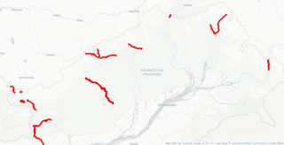
Arunachal Frontier Highway (AFH), officially notified as the National Highway NH-913 and also called Bomdila-Vijaynagar Highway (BVH), connecting Bomdila Airstrip ALG & HQ in northwest to Vijaynagar Airstrip ALG & HQ in southeast via Nafra HQ-Sarli HQ-Huri Helipad ALG & HQ-Nacho HQ-Mechuka Airstrip ALG & HQ-Monigong HQ-Jido -Hunli HQ-Hayuliang Airstrip ALG HQ-Chenquenty-Hawai HQ-Miao HQ including 800 km greenfield section and network of new tunnels & bridges, is a 2-lane paved-shoulder under-construction national highway along the India-China LAC-McMahon Line border in the Indian state of Arunachal Pradesh. The 1,748 km-long (1,086 mi) highway itself will cost ₹27,000 crore and total cost including 6 additional inter-corridors is ₹40,000 crore. In some places, this highway will run as close as 20 km from the LAC. To be constructed by MoRTH in 9 packages, all packages will be approved by the end of fy 2024-25 and construction will be completed in 2 years by 31 March 2027. Of the total route, 800km is greenfield, rest brownfield will be upgraded and tunnels will be built. This highway in the north & east Arunachal along the China border, would complement the Trans-Arunachal Highway and the Arunachal East-West Corridor as major highways spanning the whole state, pursuing the Look East connectivity policy.
East-West Industrial Corridor Highway of Arunachal Pradesh, a 2-lane and 966.78 km long including existing 274.20 km Pasighat-Manmao route, is a proposed highway across lower foothills of Arunachal Pradesh state in India from Bhairabkunda in Assam at tri-junction of Bhutan-Assam-Arunachal Pradesh in west to Kanubari tri-junction of Nagaland-Assam-Arunachal Pradesh in east.

National Highway 13, part of the larger Trans-Arunachal Highway network, is a 1,559 km long two-lane national highway across Arunachal Pradesh in India running from Tawang in northwest to Wakro in southeast. Entire route became operational in 2018 when 6.2 km long Dibang River Bridge was completed across Dibang River. Sela Tunnel, a shorter alternative route with target completion by Jan/Feb 2022, will provide all-weather connectivity. Before the renumbering of highways, it was known as NH 229 and NH52. This strategically important highway enhances Indian military's capabilities in combating the threat of China's Western Theater Command opposite India's eastern sector of Line of Actual Control.
Tawang Air Force station in Arunachal Pradesh in India has a functional heliport and fixed-wing "Advanced Landing Ground" (AGL) capable of handling Lockheed Martin C-130J Super Hercules transport aircraft. The Indian Air Force (IAF) has since 2016 upgraded 8 ALG in Arunachal Pradesh and made those operation by 2018, all of which has been offered for the operation of civil helicopter and flights for tourism and the UDAN scheme.
Lumla is a town and the headquarters of an eponymous circle in the Tawang district in Arunachal Pradesh, India. Lumla is at the southwestern corner of the Tawang district close to its border with Bhutan. Lumla is also the headquarters of a subdivision of the Tawang district and the centre of a Legislative Assembly constituency. The current member of the legislative assembly (MLA) from Lumla is Tsering Lhamu.
Sela Tunnel is a road tunnel at 3,000 metres (9,800 ft) which ensures all-weather connectivity between Guwahati in Assam and Tawang in Arunachal Pradesh. This tunnel is the longest bi-lane tunnel in the world at 13,000 feet. Situated 400 metres below the Sela Pass, the Sela Tunnel offers a vital passage, even during the winter season. The tunnel helps them move troops, weapons, and machinery quickly along the Sino-India border. It is connected with NH 13 by a new 12.4 km road and has reduced the distance between Dirang and Tawang by 10 km. It was inaugurated by PM Modi on 9 March 2024.Executed by the Border Road Organisation (BRO), the project features two tunnels and a link road. Tunnel 1 is a 980-metre-long single-tube tunnel, while Tunnel 2 is a 1,555-metre-long twin-tube tunnel, with one bi-lane tube for traffic and the other for emergency services. The link road between these tunnels spans 1,200 metres. The tunnel provides access to Tawang by an all-weather road in the western region of Arunachal Pradesh throughout the year.

In the Land of Poison Women, also known as Bishkanyar Deshot, is a 2019 Pangchenpa language feature film from India by Manju Borah. The story is based on distinguished litterateur Yeshe Dorjee Thongchi’s much acclaimed work. The language Pangchenpa is used by Monpa tribe with a population of just around 5000, settled near the India-China border region, some hundred kilometres West of Tawang in Arunachal Pradesh, India.

India–China Border Roads is a Government of India project for developing infrastructure along the Sino-Indian border by constructing strategic roads, including bridges and tunnels. The ICBR project is largely in response to Chinese infrastructure development along the borderlands with India.

Udayak, also known as Project UDAYAK is a project of the Border Roads Organisation under the Ministry of Defence of India. It was established on 1 June 1990 by separating two task forces from Project Vartak and Project Sewak. The project was tasked with taking on road and other construction work in the eastern districts of Arunachal Pradesh. The project mainly focuses on the construction and development of India–China Border Roads and inter-valley connectivity in eastern Aruanchal Pradesh. The project plays a vital role in the Arunachal Pradesh package of the SARDP-NE project and the Bharatmala project. Apart from these, the project also contributes in the social development of the people in the region.


