
Transport in Argentina is mainly based on a complex network of routes, crossed by relatively inexpensive long-distance buses and by cargo trucks. The country also has a number of national and international airports. The importance of the long-distance train is minor today, though in the past it was widely used and is now regaining momentum after the re-nationalisation of the country's commuter and freight networks. Fluvial transport is mostly used for cargo.
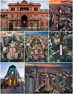
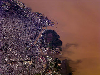
Buenos Aires, officially the Autonomous City of Buenos Aires, is the capital and largest city of Argentina. The city is located on the western shore of the Río de la Plata, on South America's southeastern coast. "Buenos Aires" can be translated as "fair winds" or "good airs", but the former was the meaning intended by the founders in the 16th century, by the use of the original name "Real de Nuestra Señora Santa María del Buen Ayre", named after the Madonna of Bonaria in Sardinia, Italy.

Rosario is the largest city in the central Argentina province of Santa Fe. The city is located 300 km (186 mi) northwest of Buenos Aires, on the west bank of the Paraná River. Rosario is the third-most populous city in the country, and is also the most populous city in Argentina that is not a capital. With a growing and important metropolitan area, Greater Rosario has an estimated population of 1,750,000 as of 2020. One of its main attractions includes the neoclassical, Art Nouveau, and Art Deco architecture that has been retained over the centuries in hundreds of residences, houses and public buildings.
El Palomar is a town in the urban agglomeration of Greater Buenos Aires in Argentina. It is located 20 km (12 mi) north-west of the Buenos Aires.

National Route 9 is a major road in Argentina, which runs from the center-east to the northwest of the country, crossing the provinces of Buenos Aires, Santa Fe, Córdoba, Santiago del Estero, Tucumán, Salta and Jujuy. It starts on Avenida General Paz, which marks the border between the Autonomous City of Buenos Aires and the surrounding province of the same name, and ends at the Horacio Guzmán International Bridge, on the La Quiaca River, traversing 1,967 km (1,222 mi). The road is a limited access motorway from Buenos Aires to Rosario.

Coronel Pringles is a city in the south of the Buenos Aires Province in Argentina, situated near the mountains of Pillahuincó. It is the government seat of the Coronel Pringles Partido.

Buenos Aires is a canton in the Puntarenas province of Costa Rica. The head city is in Buenos Aires district.
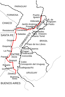
National Route 12 (RN12) is a road in Argentina, connecting the northeast section to the rest of the country. It runs through the provinces of Misiones, Corrientes, Entre Ríos and Buenos Aires.
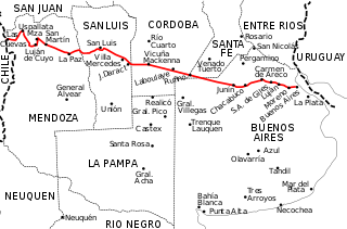
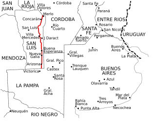
National Route 7 is a road in Argentina. It crosses the country from east to west, from the capital to the border with Chile, thus linking the Atlantic coast with the Andes, crossing the provinces of Buenos Aires, Santa Fe, Córdoba, San Luis and Mendoza. It has a total length of 1,224 km (761 mi), of which 367 km (228 mi) (30%) are freeways.
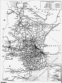
The Argentine railway network consisted of a 47,000 km (29,204 mi) network at the end of the Second World War and was, in its time, one of the most extensive and prosperous in the world. However, with the increase in highway construction, there followed a sharp decline in railway profitability, leading to the break-up in 1993 of Ferrocarriles Argentinos (FA), the state railroad corporation. During the period following privatisation, private and provincial railway companies were created and resurrected some of the major passenger routes that FA once operated.

National Route 1, also known as Buenos Aires–La Plata Highway and officially called Autopista Doctor Ricardo Balbín since 2004, is a highway that connects the 25 de Mayo Highway and Paseo del Bajo in the city of Buenos Aires with the Provincial Route 11, near the city of La Plata. It has a length of 50 km (31 mi) with two or four lanes on each direction in different areas, and is indicated in red in the map.

Autovía 2 Juan Manuel Fangio is an Argentine dual carriageway, which runs from Buenos Aires to Mar del Plata. The road was a National Route until 1990 when it was transferred to the Government of Buenos Aires Province. The Autovía 2 extends from the junction of Provincial Routes 1 and 36 and National Route A004, just on the traffic circle "Juan María Gutiérrez", which is the limit of Berazategui and Florencio Varela districts.
Buenos Aires is a district of the Buenos Aires canton, in the Puntarenas province of Costa Rica.
Buenos Aires, the capital of Argentina, has a temperate climate, which is classified as a humid subtropical climate (Cfa) under the Köppen climate classification with four distinct seasons. Summers are hot and humid with frequent thunderstorms while winters are cool and drier with frosts that occurs on average twice per year. Spring and fall are transition seasons characterized by changeable weather. At the central observatory, the highest recorded temperature is 43.3 °C (109.9 °F) while the lowest recorded temperature is −5.4 °C (22.3 °F).
Pocosol is a district of the San Carlos canton, in the Alajuela province of Costa Rica.
Buenos Aires is a district of the Palmares canton, in the Alajuela province of Costa Rica.
Colinas is a district of the Buenos Aires canton, in the Puntarenas province of Costa Rica.

National Route 8 is a highway located in Argentina, that connects the provinces of Buenos Aires, Santa Fe, Córdoba and San Luis. The route starts at the link with National Route 9 in the northwest of Greater Buenos Aires, between the towns of El Talar, El Triángulo, Ricardo Rojas and Ingeniero Pablo Nogués, to the link with Provincial Route 55 in Villa Mercedes, San Luis Province at 695 km (432 mi).
Provincial Route 55 is a 458 km (285 mi) long paved highway that runs through San Luis Province, from north to south at the eastern end, near the border with the provinces of Córdoba and La Pampa.
Provincial Route 105 is a highway located in the Argentine province of La Pampa. Its total route is 180 km, being partially asphalt.
