
Barrancabermeja is a municipality and city in Colombia, located on the shore of the Magdalena River, in the western part of the department of Santander. It is home to the largest oil refinery in the country, under direct management of ECOPETROL. Barrancabermeja is known as the Oil Capital of Colombia.
Puerto Ayacucho is the capital and largest city of Amazonas State in Venezuela. Puerto Ayacucho is located across the Orinoco River from the Colombian village of Casuarito.

Puerto Boyacá is a Colombian river-port town and municipality by the Magdalena River in the Boyacá Department, where is also considered a Special Trade Zone due to its port status. Its main industries are oil exploration and processing. In the 1980s and early 1990s, Puerto Boyacá was affected intensively by the Colombian Armed Conflict.

Inírida, formerly Puerto Inírida, is the capital city, and a municipality, of the department of Guainía in Colombia. It was established in 1963 on the site of the small village of Obando, at the time in the municipality of San Felipe. The municipality was renamed in 1974. The municipal population of 31,514 is mostly indigenous and accounts for about a third of the department's population.

El Peñol is a town and municipality in Antioquia Department, Colombia. The population was 16,223 at the 2018 census. It is part of the subregion of Eastern Antioquia. The town is nationally known for the nearby monolith known also as El Peñol, which is a tourist attraction.

Puerto Berrío is a municipality and town in the Colombian department of Antioquia. It is part of the Magdalena Medio Antioquia sub-region.

San Luis is a municipality in Colombia, located in the department of Antioquia. It is limited in the north by the municipalities of San Carlos and Puerto Nare, in the east by the municipality of Puerto Triunfo, in the south by the municipality of San Francisco and in the west by the municipalities of Cocorná and Granada.
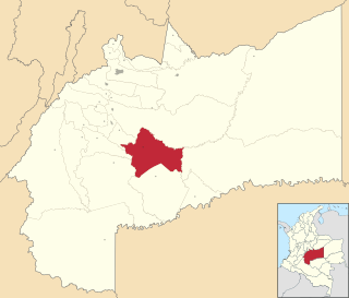
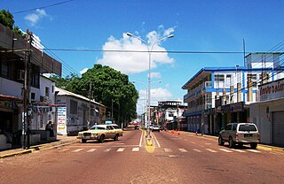
Puerto Lleras is a town and municipality in the Meta Department, Colombia.
Germán Olano Airport is an airport serving Puerto Carreño, the capital of Vichada Department in Colombia. It is also known as Puerto Carreño Airport. The airport is 1.5 kilometres (0.93 mi) west of and parallels the Orinoco River, locally Colombia's border with Venezuela.

César Gaviria Trujillo Airport is an airport serving the town of Inírida in the Guainía Department of Colombia. The airport is named in honor of César Gaviria Trujillo, a former President of Colombia and Secretary General of the Organization of American States.

Caucayá Airport is an airport serving the river town of Puerto Leguízamo in the Putumayo Department of Colombia. Puerto Leguízamo is on the Putumayo River, locally the border with Peru.
Cacique Aramare Airport is an airport serving Puerto Ayacucho, the capital of the Amazonas state in Venezuela. The airport and city are on the Orinoco River, locally the border between Venezuela and Colombia.
Puerto Deseado Airport is an airport serving Puerto Deseado, a port town at the mouth of the Deseado River in the Santa Cruz Province of Argentina. As of February 2012, no scheduled services are operated.
Santa Cruz Airport is an airport serving Puerto Santa Cruz, a town on the Santa Cruz River estuary in the Santa Cruz Province of Argentina. The airport is 3 kilometres (2 mi) inland from the town.
Cabo Juan Román Airport is an airport serving Puerto Aysén, a city at the head of the Aysén Fjord in the Aysén Region of Chile.
Sambú Airport is an airport serving the Sambú River towns of Sambú and Puerto Indio, Panama.
Puerto Gaitán Airport is an airport serving the river town of Puerto Gaitán in the Meta Department of Colombia.
Morela Airport is an airport serving the Magdalena River town of Puerto Berrío in the Antioquia Department of Colombia. The runway is 3 kilometres (1.9 mi) south of the town, along the west bank of the river.
Velasquez Airport is an airport serving the Magdalena River town of Puerto Boyacá in the Boyacá Department of Colombia. The runway is in the country 13 kilometres (8.1 mi) east of Puerto Boyacá.

