
Pulau Tekong, also known colloquially as Tekong, is the second-largest of Singapore's outlying islands and found off Singapore's northeastern coast, east of Pulau Ubin. The island is used by the Singaporean military and is not open to the general public. Transport to the island for permitted persons is via SAF Changi Ferry Terminal.

Pulau Ubin, also simply known as Ubin, is an island situated in the north east of Singapore, to the west of Pulau Tekong. The granite quarry used to be supported by a few thousand settlers on Pulau Ubin in the 1960s, but only about 38 villagers remained as of 2012. It is one of the last rural areas to be found in Singapore, with an abundance of natural flora and fauna. The island forms part of the Ubin–Khatib Important Bird Area (IBA), identified as such by BirdLife International because it supports significant numbers of visiting and resident birds, some of which are threatened. Today, the island is managed by the National Parks Board, compared to 12 agencies managing different areas of the island previously.

Pedra Branca is an outlying island and the easternmost point of Singapore. The name of the island refers to whitish guano deposited on the rock. The island consists of a small outcrop of granite rocks with an area of about 8,560 square metres (92,100 sq ft) at low tide. During the low water spring tide it measures, at its longest, 137 metres (449 ft) and has an average width of 60 metres (200 ft). Pedra Branca is situated at 1°19′48″N104°24′27″E, where the Singapore Strait meets the South China Sea. The island has been the subject of a territorial dispute between Malaysia and Singapore which was resolved in Singapore's favour.
Seletar is an area located in the north-east of Singapore. Its name can also refer to the Seletar Planning Area, situated in the North-East Region of Singapore. The place name was derived from the Malay subgroup who were indigenous to the area, the Orang Seletar. It shares boundaries with the planning areas of Sengkang to the south, Punggol to the east, Yishun and Simpang to the west, as well as the Straits of Johor to the north.
Pulau Semakau is located to the south of the main island of Singapore, off the Straits of Singapore. The Semakau Landfill is located on the eastern side of the island, and was created by the amalgamation of Pulau Sakeng, and "anchored" to Pulau Semakau. The Semakau Landfill is Singapore's first offshore landfill and now the only remaining landfill in Singapore.
Pulau Bukom, also known as Pulau Bukum, is a small restricted-access island belonging to Singapore that is located about five kilometres to the south of Mainland Singapore, off the Straits of Singapore. The size of Pulau Bukom is about 1.45 km2 (0.56 sq mi).

The Malaysia–Singapore border is an international maritime border between the Southeast Asian countries of Malaysia, which lies to the north of the border, and Singapore to the south. The boundary is formed by straight lines between maritime geographical coordinates running along or near the deepest channel of the Straits of Johor.

Pulau Sajahat, was a small island about 1.2 hectares located off the north-eastern coast of Singapore, near Pulau Tekong. The island, together with its smaller companion Pulau Sejahat Kechil, has been subsumed by Pulau Tekong with the land reclamation works on Pulau Tekong's southern and northwestern coasts.
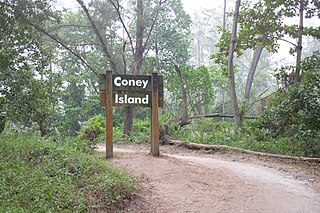
Coney Island, alternatively known as Pulau Serangoon, is a 133-hectare island located off the northeastern coast of Singapore within the town of Punggol, between Pulau Ubin to its northeast and the mainland to its southwest.
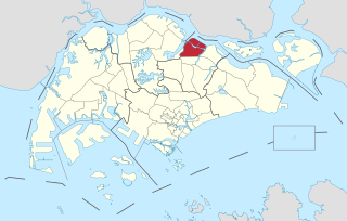
The North-Eastern Islands is a planning area and a group of islands located within the North-East Region of Singapore. The cluster is made up of three islands, namely Pulau Tekong, Pulau Tekong Kechil and Pulau Ubin. Pulau Tekong and Pulau Tekong Kechil was formerly home to 10 villages while Pulau Ubin was home to a number of granite quarries. At present, Pulau Tekong houses the Singapore Armed Forces Basic Military Training Centre while Pulau Ubin is one of the last areas in Singapore that has been preserved from urban development, concrete buildings and tarmac roads.
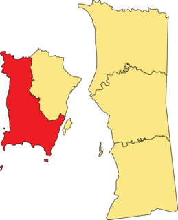
The Southwest Penang Island District is a district within the Malaysian state of Penang. The district covers the southwestern half of Penang Island and borders the Northeast Penang Island District to the east. It has an area of 175 km2 (68 sq mi) and a population of 197,131 as of 2010. Balik Pulau is the district's administrative centre, while Bayan Lepas is the largest town within the district.
Pulau Pisang is a small island in Pontian District, Johor, Malaysia.
The Pulau Pisang Lighthouse is a lighthouse located on the highest point of Pulau Pisang, an island in the Strait of Malacca 15 kilometres from Pontian Kechil, Johor, Malaysia.

The Pedra Branca dispute was a territorial dispute between Singapore and Malaysia over several islets at the eastern entrance to the Singapore Strait, namely Pedra Branca, Middle Rocks and South Ledge. The dispute began in 1979 and was largely resolved by the International Court of Justice (ICJ) in 2008, which opined that Pedra Branca belonged to Singapore and Middle Rocks belonged to Malaysia. Sovereignty over South Ledge belongs to the state in the territorial waters of which it is located.

Keppel Island is a small private island located in the precinct of HarbourFront in Bukit Merah, Singapore. The island is largely flat, situated in northern part of Keppel Bay, between Singapore's main island and the island of Sentosa.
Sisters’ Islands Marine Park is a 400,000 square metre(40ha) marine park located in Southern Islands planning area, Singapore, which was designated a marine protected area (MPA) by the Government of Maritime and Port Authority of Singapore in 2014. The park encompasses the land and waters surrounding Sisters' Islands, and also covers the western coasts of both St John's Island and Pulau Tekukor.
Lazarus Island, also known as Pulau Sakijang Pelepah, is one of the Southern Islands in Singapore. It is south of the main island of Singapore, off the Straits of Singapore and is uninhabited.
Pulau Seletar is an island situated in the Straits of Johor off the northern coast of Singapore. Located within Singapore waters, it has an area of 38.5 hectare. It lies within a bay into which several streams flow, including the waters of mainland Singapore's only hot spring.
Pulau Saigon was a small island in the Singapore River. It used to be located between the banks of Robertson Quay.
