Transport within Singapore is mainly land-based. Many parts of Singapore, including islands such as Sentosa and Jurong Island are accessible by road. The other major form of transportation within Singapore is rail: the Mass Rapid Transit which runs the length and width of Singapore, and the Light Rail Transit which runs within a few neighbourhoods. The main island of Singapore is connected to the other islands by ferryboat services.

Jurong is a geographical region located at the south-westernmost point of the West Region of Singapore. Although mostly vaguely defined, the region's extent roughly covers the planning areas of Jurong East, Jurong West, Boon Lay, and Pioneer, along with Jurong Island in the Western Islands cluster and the southernmost portions of the Western Water Catchment. Should it be described at its greatest historical extent, the region can also include present-day Bukit Batok and Tuas as well. Jurong also covers several offshore islands as well, including Pulau Damar Laut and Pulau Samulun, both of which are located within the planning areas of Jurong East and Boon Lay respectively; along with the aforementioned Jurong Island. The coastline of the region on mainland Singapore, faces the strait of Selat Jurong, while the southernmost island of the region, Jurong Island, faces the strait of Selat Pandan.

Jurong Island is an island located to the southwest of the main island of Singapore. It was formed from the amalgamation of seven offshore islands, the islands of Pulau Ayer Chawan, Pulau Ayer Merbau, Pulau Merlimau, Pulau Pesek, Pulau Pesek Kechil, Pulau Sakra, Pulau Seraya, Pulau Meskol, Pulau Mesemut Laut, Pulau Mesemut Darat and Anak Pulau. This was done through Singapore's land reclamation efforts. Land reclamation on Jurong Island was completed on 25 September 2009, 20 years earlier than scheduled. Pulau Buaya was joined to Jurong Island via reclamation in 2010. Jurong Island forms a land area of about 32 km2 (12 sq mi) from an initial area of less than 10 km2 (4 sq mi), and is the largest of Singapore's outlying islands.

Pasir Ris is a planning area and residential town located in the East Region of Singapore. It is bordered by Tampines and Paya Lebar to the south, Sengkang to the southwest and Changi to the east. The planning area also shares riverine boundary with Punggol to the west, separated by the Serangoon River, as well as having a maritime boundary with the North-Eastern Islands planning area, across the Straits of Johor.

The Port of Singapore refers to the collective facilities and terminals that conduct maritime trade and handles Singapore's harbours and shipping. It is ranked as the top maritime capital of the world since 2015. Currently the world's second-busiest port in terms of total shipping tonnage, it also transships a third of the world's shipping containers, half of the world's annual supply of crude oil, and is the world's busiest transshipment port. It was also the busiest port in terms of total cargo tonnage handled until 2005 when it was surpassed by the Port of Shanghai. Thousands of ships drop anchor in the harbour at all times, connecting the port to over 600 other ports in 123 countries and spread over six continents.

Tuas is a planning area located within the West Region of Singapore. It is bounded by the Western Water Catchment to its north, Pioneer to its east and the Straits of Johor to its west. Tuas also shares a maritime boundary with the Western Islands planning area to its east.

Jurong Port Pte Ltd is a port operator headquartered in Singapore. Jurong Port, which operates the only multi-purpose port in Singapore, handles bulk, break-bulk and containerised cargo. It handled over 40,000 vessel-calls annually in 2019.

Pasir Panjang is an area located at the southern part of Queenstown in Singapore. Kent Ridge Park is a topographical feature which runs adjacent to Pasir Panjang.

Changi Village is a modern village situated at the northern tip of Changi which is at the eastern end of Singapore. It is the usual connecting point for travellers heading to Pulau Ubin or Malaysia by ferry. Fishermen in the kelongs located in the Serangoon Harbour offshore also use this jetty as a drop off point to come onto mainland. Changi Village also has many resorts and leisure facilities to cater for a weekend getaway for many Singaporeans. The area is classified by Urban Redevelopment Authorities as under the planning area of Changi and in the subzone of Changi Point. It is also classified under District 17 for property indexing.
Pulau Bukom, also known as Pulau Bukum, is a small restricted-access island belonging to Singapore that is located about five kilometres to the south of Mainland Singapore, off the Straits of Singapore. The size of Pulau Bukom is about 1.45 km2 (0.56 sq mi).
Muara Town or simply Muara is a port town in Brunei-Muara District, Brunei, about 28 kilometres (17 mi) from the capital Bandar Seri Begawan. The population of the town proper was 2,102 in 2016. It is home to Muara Port, the country's primary deep water port.
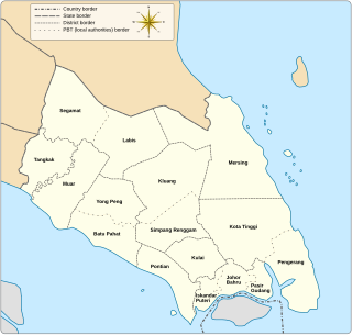
Pengerang is a municipality in Kota Tinggi District, in the Malaysian state of Johor. It was established in 2017. It is home to Pengerang Integrated Petroleum Complex, a hub for the oil and gas industry in the country.

This article shows the notable future developments in Singapore. Most developments are found in the Downtown Core of Singapore. Majority of them are currently under construction with most to be completed within the next five years.

The Western Water Catchment is a planning area located in the West Region of Singapore. The planning area borders Tuas and Pioneer to its south, Sungei Kadut, Choa Chu Kang and Tengah to its east, Jurong West to its southeast, Lim Chu Kang to its north and the Straits of Johor to its west.

Serangoon Harbour is a harbour in Singapore located between the mainland island of Singapore and Pulau Ubin.
Teban Gardens is a residential precinct located in Jurong East, Singapore. Immediately north of Pandan Reservoir, it comprises exclusively public housing built by the JTC Corporation and Housing and Development Board.
The Western Islands is a planning area located within the West Region of Singapore. It comprises a collection of islands located in the south-western waters of Singapore, namely Jurong, Bukum and Sudong Islands.
Tuas View is an industrial area in the south-westernmost region of Singapore.
Pulau Samulun is an offshore island in Jurong Industrial Estate, Singapore. It is separated from mainland Singapore by Selat Samulun. It is only less than a kilometre away from Singapore mainland. Jurong Shipyard is located in Pulau Samulun and it also houses a food centre that caters to the workers working there. Samulun is from "sembulun" a tribe of Orang Laut who once lived here.
Tanjung Langsat Port is a port in Pasir Gudang, Johor Bahru District, Johor, Malaysia. Wholly owned by Johor Corporation, the port handles bulk cargo such as liquefied petroleum gas (LPG) and dangerous chemicals.
