Transport within Singapore is mainly land-based. Many parts of Singapore, including islands such as Sentosa and Jurong Island are accessible by road. The other major form of transportation within Singapore is rail: the Mass Rapid Transit which runs the length and width of Singapore, and the Light Rail Transit which runs within a few neighbourhoods. The main island of Singapore is connected to the other islands by ferryboat services.

Sentosa Island, known mononymously as Sentosa, and formerly Pulau Blakang Mati, is an island located off the southern coast of Singapore's main island. The island is separated from the main island of Singapore by a channel of water, the Keppel Harbour, and is adjacent to Pulau Brani, a smaller island wedged between Sentosa and the main island.

Pulau Ubin, also simply known as Ubin, is an island situated in the north east of Singapore, to the west of Pulau Tekong. The granite quarry used to be supported by a few thousand settlers on Pulau Ubin in the 1960s, but only about 38 villagers remained as of 2012. It is one of the last rural areas to be found in Singapore, with an abundance of natural flora and fauna. The island forms part of the Ubin–Khatib Important Bird Area (IBA), identified as such by BirdLife International because it supports significant numbers of visiting and resident birds, some of which are threatened. Today, the island is managed by the National Parks Board, compared to 12 agencies managing different areas of the island previously.

Batam is the largest city in the province of Riau Islands, Indonesia. The city administrative area covers three main islands of Batam, Rempang, and Galang, as well as several small islands. Batam Island is the core urban and industrial zone, while both Rempang Island and Galang Island maintain their rural character and are connected to Batam Island by short bridges. Batam is an industrial boomtown, an emerging transport hub, and part of a free trade zone in the Indonesia–Malaysia–Singapore Growth Triangle, located 20 km (12 mi) off Singapore's south coast and also part of the Indonesia–Malaysia–Thailand Growth Triangle.

HarbourFront MRT station is an underground Mass Rapid Transit (MRT) interchange station on the North East line (NEL) and Circle line (CCL) in Bukit Merah planning area, Singapore, underneath Telok Blangah Road. This station is directly connected to VivoCity, and is the nearest MRT station to Sentosa. The station is also close to HarbourFront Bus Interchange, HarbourFront Centre and the Singapore Cruise Centre.
Keppel Harbour, also called the Keppel Channel and formerly New Harbour, is a stretch of water in Singapore between the mainland and the southern islands of Pulau Brani and Sentosa. Its naturally sheltered and deep waters was to meet the requirements of British colonists attempting to establish a Far East maritime colony in that part of the world, and thereby setting the stage for the eventual formation of Singapore as a successful independent state.

Pulau Brani is an island located off the southern coast of Singapore, near Keppel Harbour. The island is situated between the main island of Singapore and the resort island of Sentosa, and is linked to the mainland via Brani Terminal Avenue. The area of Pulau Brani is 1.22 square kilometres.
Pulau Hantu is located to the south of the main island of Singapore, off the Straits of Singapore. Pulau Hantu is actually made up of two islets: Pulau Hantu Besar and Pulau Hantu Kechil, with a total area of 12.6 hectares. At low tide, it is possible to wade across the shallow lagoon between the two islands, but not at high tide.
Keppel Corporation is a Singaporean conglomerate headquartered in Keppel Bay Tower, HarbourFront. The company consists of several affiliated businesses that specialises in offshore & marine, property, infrastructure and asset management businesses.
Marina Bay is a bay located in the Central Area of Singapore, surrounded by the perimeter of four other planning areas, the Downtown Core, Marina East, Marina South and Straits View. The area surrounding the bay itself, also called Marina Bay, is a 360 hectare extension to the adjacent Central Business District. It is also the new downtown of Singapore, built on reclaimed land.

The Southern Islands is a planning area consisting of a collection of islets located within the Central Region of Singapore, once home to the native Malay islanders and sea nomads before they were relocated to the mainland for urban redevelopment and future use. The islands that form the planning area are Kusu Island, Lazarus Island, Pulau Seringat, Pulau Tekukor, Saint John's Island, Sentosa and the two Sisters' Islands. The islands encompass a total land area of about 5.58 square kilometres (2.15 sq mi). The Sentosa Development Corporation oversaw the development and maintenance of these offshore islands south of Singapore from 1976 to March 2017, when it handed it back to the Singapore Land Authority.

This article shows the notable future developments in Singapore. Most developments are found in the Downtown Core of Singapore. Majority of them are currently under construction with most to be completed within the next five years.
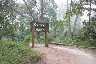
Coney Island, alternatively known as Pulau Serangoon, is a 133-hectare island located off the northeastern coast of Singapore within the town of Punggol, between Pulau Ubin to its northeast and the mainland to its southwest.

The Western Water Catchment is a planning area located in the West Region of Singapore. The planning area borders Tuas and Pioneer to its south, Sungei Kadut, Choa Chu Kang and Tengah to its east, Jurong West to its southeast, Lim Chu Kang to its north and the Straits of Johor to its west.

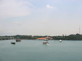
Serangoon Harbour is a harbour in Singapore located between the mainland island of Singapore and Pulau Ubin.
Pulau Busing is a restricted-access island and a hub for oil shipping located off the southwestern coast of Singapore. The island is occupied by Tankstore Ltd, a petroleum storage company. Heavily industrialised, the island is home to oil and chemical storage facilities, at least one marine offshore terminal, and a fuel oil refinery.
Long Ya Men or Dragon's Teeth Gate, is the name Chinese explorer Wang Dayuan recorded for Batu Belayar, a craggy granite outcrop that formerly stood at the gateway to Keppel Harbour in Singapore. In his description, “The strait runs between the two hills of the Danmaxi (Temasek) natives which looked like dragon’s teeth.” From there, the name Long Ya Men or Dragon Teeth’s Gate was born.
The following lists events that happened during 2008 in the Republic of Singapore.
Sisters’ Islands Marine Park is a 400,000 square metre(40ha) marine park located in Southern Islands planning area, Singapore, which was designated a marine protected area (MPA) by the Government of Maritime and Port Authority of Singapore in 2014. The park encompasses the land and waters surrounding Sisters' Islands, and also covers the western coasts of both St John's Island and Pulau Tekukor.

William Arthur Bates Goodall (1880–1941) was a British soldier and engineer who achieved a period of popular renown as a voluntary castaway on the island of Pulau Serimbun in the Johore Straits west of Singapore during the 1930s. The island, only two acres in area, had been uninhabited for many years and was considered to be haunted. Goodall came to be regarded as a local Robinson Crusoe in Singapore, however when his story spread through the international press he became known as 'the ruler of the world's tiniest kingdom'.

