
Blackfoot Mountain is located in the Lewis Range, Glacier National Park in the U.S. state of Montana. To the north of Blackfoot Mountain lies Blackfoot Glacier, one of the largest glaciers in the park. The stagnant Pumpelly Glacier is located to the immediate east and northeast of the mountain.

Curly Bear Mountain is located in the Lewis Range, Glacier National Park in the U.S. state of Montana. Curly Bear Mountain is easily seen from the village of Saint Mary, Montana rising just west of Divide Mountain. The peak was named after Blackfoot warrior and historian Curly Bear (Kyáiyo-xusi).

Divide Mountain is located in the Lewis Range, Glacier National Park in the U.S. state of Montana. Divide Mountain is located south of Saint Mary, Montana on the border of Glacier National Park and the Blackfeet Indian Reservation.
Gable Mountain is located in the Lewis Range, Glacier National Park in the U.S. state of Montana. Gable Mountain is in the northeastern section of Glacier National Park, approximately 3 miles (4.8 km) southwest of the prominent Chief Mountain.
Ipasha Peak is located in the Lewis Range, Glacier National Park in the U.S. state of Montana. Ipasha Peak is 1.29 miles (2.08 km) south of Mount Merritt and is in the northeastern section of Glacier National Park. Ahern Glacier is located on the southeastern slopes of the mountain while the Ipasha Glacier is to the southwest of the peak. Helen Lake lies almost 4,500 feet (1,400 m) below the summit of Ipasha Peak to the southeast.
Kaina Mountain is located in the Lewis Range, Glacier National Park in the U.S. state of Montana. Kaina Mountain is in the northeastern section of Glacier National Park and north of Kaina Lake.
Kupunkamint Mountain is located in the Lewis Range, Glacier National Park in the U.S. state of Montana. Kupunkamint Mountain is in the southeastern section of Glacier National Park.

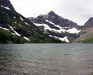
Mount Henkel is located in the Lewis Range, Glacier National Park in the U.S. state of Montana. Kennedy Lake is just to the north of the mountain.

Mount Logan is located in the Lewis Range, Glacier National Park in the U.S. state of Montana. Logan Glacier is immediately north of Mount Logan and Red Eagle Glacier lies to the east. Mount Logan is situated along the Continental Divide.
Seward Mountain is located in the Lewis Range, Glacier National Park in the U.S. state of Montana.
Split Mountain is located in the Lewis Range, Glacier National Park in the U.S. state of Montana.
Boulder Peak is located in the Livingston Range, Glacier National Park in the U.S. state of Montana. The remnant Boulder Glacier is situated on the northern slopes of the mountain.
McPartland Mountain is located in the Livingston Range, Glacier National Park in the U.S. state of Montana. McPartland Mountain is a little more than a mile south of Heavens Peak.
Sheep Mountain is located in the Lewis Range, Glacier National Park in the U.S. state of Montana.
Tinkham Mountain is located in the Lewis Range, Glacier National Park in the U.S. state of Montana.
Pumpelly Glacier is in Glacier National Park in the U.S. state of Montana. The glacier is situated immediately northeast of Blackfoot Mountain at an elevation between 8,500 and 8,000 ft above sea level. Pumpelly Glacier is just west of the Continental Divide and adjacent to Pumpkin Glacier, the two glaciers separated by crevasses. The glacier was named after Raphael Pumpelly who had first sighted the glacier in 1883. Pumpelly and Pumpkin Glaciers cover 310 acres (1.3 km2) as of 2005, a 15 percent reduction in area since 1966.
Pumpkin Glacier is in Glacier National Park in the U.S. state of Montana The glacier is northeast of Blackfoot Mountain and adjacent to Pumpelly Glacier, the two glaciers separated by crevasses. Pumpkin Glacier covers approximately 35 acres (0.14 km2) at elevations between 8,500 feet (2,600 m) and 8,000 feet (2,400 m) above sea level. Pumpkin Glacier is immediately west of the Continental Divide. Pumpkin and Pumpelly Glaciers covered 310 acres (1.3 km2) as of 2005, a 15 percent reduction in area since 1966.
Upper Two Medicine Lake is located in Glacier National Park, in the U. S. state of Montana. The lake is just east of the Continental Divide in the Two Medicine region of Glacier National Park. Upper Two Medicine Lake is in a cirque and surrounded by a number of peaks including Lone Walker Mountain, Mount Helen and Pumpelly Pillar. Upper Two Medicine Lake is a 5 miles (8.0 km) hike from the Two Medicine Store.
No Name Lake is located in Glacier National Park, in the U. S. state of Montana. The lake is just north of Pumpelly Pillar in the Two Medicine region of Glacier National Park. No Name Lake is a 5 miles (8.0 km) hike from the Two Medicine Store.
B-7 Pillar is located in the Lewis Range, Glacier National Park in the U.S. state of Montana. The summit is located just northeast of Iceberg Peak.


