Related Research Articles

Comox is a town on the southern coast of the Comox Peninsula in the Strait of Georgia on the eastern coast of Vancouver Island, British Columbia. Thousands of years ago, the warm dry summers, mild winters, fertile soil, and abundant sea life attracted First Nations, who called the area kw'umuxws.

The K’ómoks or K'omoks, usually known in English as the Comox people, are an indigenous group of Coast Salishan-speaking people in Comox, British Columbia and in Toba Inlet and the Malaspina Peninsula areas of the British Columbia mainland across Georgia Strait. They historically spoke the Komox language (Comox-Sliammon), and were divided in two main dialect and tribal groupings, which are known by academics as Island Comox and Mainland Comox.

Courtenay is a city on the east coast of Vancouver Island, in the Canadian province of British Columbia. It is the largest community and only city in the area commonly known as the Comox Valley, and the seat of the Comox Valley Regional District, which replaced the Comox-Strathcona Regional District. Courtenay is 4 km (2.5 mi) west of the town of Comox, 7 km (4.3 mi) northeast of the village of Cumberland, 5 km (3.1 mi) northwest of the unincorporated settlement of Royston, and 108 km (67 mi) northwest of Nanaimo. Along with Nanaimo and Victoria, it is home to The Canadian Scottish Regiment, a Primary Reserve infantry regiment of the Canadian Armed Forces.
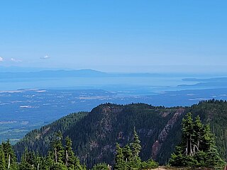
The Comox Valley is a region on the east coast of Vancouver Island, British Columbia, Canada, that includes the city of Courtenay, the town of Comox, the village of Cumberland, and the unincorporated settlements of Royston, Union Bay, Fanny Bay, Black Creek, and Merville. The communities of Denman Island and Hornby Island are also considered part of the Comox Valley. The Comox Valley contains the 47th largest metropolitan area in Canada with a population of about 76,000 as of 2022
Union Bay is south of Hart Creek on the east coast of central Vancouver Island, British Columbia. This Comox Valley community on BC Highway 19A is by road about 93 kilometres (58 mi) north of Nanaimo, and 14 kilometres (9 mi) south of Courtenay.
Cumberland is an incorporated village municipality east of Perseverance Creek, near the east coast of central Vancouver Island, British Columbia. The Comox Valley community is west of BC Highway 19 and is by road about 105 kilometres (65 mi) northwest of Nanaimo and 10 kilometres (6 mi) southwest of Courtenay.
Black Creek is a community on the eastern side of Vancouver Island, British Columbia, Canada. It is approximately 16 kilometres (9.9 mi) north of Courtenay. It is primarily an agricultural hamlet and bedroom community to Courtenay and Campbell River - approximately 20 kilometres (12 mi) to the north. It is part of Electoral Area C in the Comox Valley Regional District.

The Musqueam Indian Band is a First Nations band government in the Canadian province of British Columbia. It is the only First Nations band whose reserve community lies within the boundaries of the City of Vancouver.

The Pentlatch or Pentl’ach or Puntlatch or Puntledge language is a Salishan language that was spoken on Canada's Vancouver Island in a small area between Comox and Nanaimo, British Columbia. The Pentlatch people formerly numbered at least 3,000 with at least 90 settlements in the area. The language became extinct in the 1940s after the death of the last fluent speaker in 1940.

Little Qualicum Falls Provincial Park is a provincial park in British Columbia, Canada, on central Vancouver Island, that encompasses the entire southern shore of Cameron Lake. The Island Rail Corridor line to Port Alberni passes through the park.
Georges P. Vanier Secondary School is a high school in Courtenay, British Columbia, Canada. The school was named after Georges P. Vanier, one of Canada's most popular Governors General.
Franklin River in Vancouver Island, British Columbia, is located between Alberni Inlet and Barkley Sound, was named as part of the Vancouver Island Exploration Expedition of 1864. The river was named for Selim Franklin, Esquire, who was Chairman of the Exploration Committee.
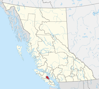
The Comox Valley Regional District is a regional district in British Columbia, Canada. It was created on February 15, 2008, encompassing the southeastern portions of the former Regional District of Comox-Strathcona, and centred about the Comox Valley. The partition left the new Comox Valley Regional District with only 8.4 percent of the former Comox-Strathcona's land area, but 57.9 percent of its population. The CVRD covers an area of 2,425 square kilometres, of which 1,725 square kilometres is land, and serves a population of 66,527 according to the 2016 Census. The district borders the Strathcona Regional District to the northwest, the Alberni-Clayoquot Regional District to the southwest, and the Regional District of Nanaimo to the southeast, as well as the Powell River Regional District along the Strait of Georgia to the east.
Little River is a community in the Comox Valley region of Vancouver Island, British Columbia, Canada.
The Qualicum River or Big Qualicum River is a river on the east coast of Vancouver Island, British Columbia, Canada, flowing northeast from its headwaters in Horne Lake into the Strait of Georgia just south of Qualicum Bay, near the town of Qualicum Beach. The river's name comes from that of the Qualicum people.
The K'ómoks First Nation, also known as the Comox Indian Band, is the band government of the Island Comox or K'ómoks people of Vancouver Island, British Columbia, Canada. Closely allied to the Cape Mudge and Campbell River First Nations, historically they were a Coast Salish people since integrated into Kwakwaka'wakw society. Originally part of the Laich-kwil-tach Council of Chiefs, which is a treaty society, they are now negotiating independently in the BC Treaty Process. They remain a member government of the Kwakiutl District Council.
The Germansen River, formerly Germansen Creek, is a major south tributary of the Omenica River in the Northern Interior of British Columbia, Canada. The settlement and former gold-rush centre of Germansens Landing is located at its confluence with the Omineca. Along its course is Germansen Lake at 55°41′45″N124°51′10″W, south of which is the Germansen Range and Mount Germansen.
The Tsolum River is a short river on Vancouver Island, British Columbia, Canada. It joins the Puntledge River to form the Courtenay River in the City of Courtenay.

The Courtenay River is a short river on Vancouver Island, British Columbia, Canada, being the name of the channel from the confluence of the Puntledge and Tsolum Rivers, in the City of Courtenay, and its outlet into Comox Harbour, which is a part of the Strait of Georgia.
The Comox Land District is one of the 59 land districts of British Columbia, Canada, which are part of the cadastral divisions of British Columbia, created with rest of those on Vancouver Island via the Lands Act of the Colony of Vancouver Island. The British Columbia government's BC Names system, a subdivision of GeoBC, defines a land district as "a territorial division with legally defined boundaries for administrative purposes". All land titles and surveys use the Land District system as the primary point of reference, and entries in BC Names for placenames and geographical objects are so listed.
References
Coordinates: 49°41′45″N124°59′41″W / 49.69583°N 124.99472°W