
Transport in Ghana is accomplished by road, rail, air and water. Ghana's transportation and communications networks are centered in the southern regions, especially the areas in which gold, cocoa, and timber are produced. The northern and central areas are connected through a major road system.

The R34 is a long provincial route in South Africa that connects Vryburg with Richards Bay via Kroonstad and Newcastle. It passes through three provinces, North West, the Free State and KwaZulu-Natal.
The R103 is a Regional Route in South Africa that is the designation for some of the old sections of roads that were previously the N3, prior to upgrading. It only has 3 sections, from Hillcrest to Ladysmith, from Warden to Villiers and from Heidelberg to Johannesburg.
The R104 is a Regional Route in South Africa that is the designation for some of the old sections of roads that were previously the N4, prior to upgrading. It connects Pretoria with Middelburg in Mpumalanga via Bronkhorstspruit and Witbank. It also connects Pretoria with Rustenburg in the North West via Hartbeespoort & Mooinooi.

The Greater Accra Region has the smallest area of Ghana's 16 administrative regions, occupying a total land surface of 3,245 square kilometres. This is 1.4 per cent of the total land area of Ghana. It is the second most populated region, before the Ashanti Region, with a population of 5,455,692 in 2021, accounting for 17.7 per cent of Ghana's total population.

The N4 is a national route in South Africa that runs from Skilpadshek on the Botswana border, past Rustenburg, Pretoria, eMalahleni and Mbombela, to Komatipoort on the Mozambique border. It forms the South African section of the Trans-Kalahari Corridor, which runs from Walvis Bay to Maputo, meaning that it links the east and west coasts of Southern Africa. Since the completion of the A2 through Botswana, the entire Corridor is now a world-class standard highway; it features at least one carriageway in each direction of high-speed traffic plus a paved shoulder for its entire length.

Roads in Ghana form a network of varied quality and capacity. Responsibility for the road network differs between trunk and non-trunk routes. Trunk roads, which are the most important roads, are administered by the Ghana Highway Authority, which was established in 1974 to develop the trunk road network. Ghana's 13,367 km of trunk roads accounts for 33% of the total road network of 40,186 km. The Department of Feeder Roads is responsible for the construction and maintenance of feeder roads in Ghana, while responsibility for urban roads lies with the Department of Urban Roads.
Wegbe Kpalime is a village located in the South Dayi District of the Volta Region of Ghana.
Dabala is a town in the Volta Region of Ghana. The town is known for the Dabala Secondary Technical School. The school is a second cycle institution.
The R114 is a regional route in Gauteng, South Africa that runs from Muldersdrift to Centurion. The designation R114 is applied to sections of road that were previously part of the N14 that have been replaced by newly built freeway sections.
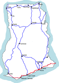
The N1 or National Highway 1 is a national highway in Ghana that begins at the border with Ivory Coast at Elubo and runs through Sekondi-Takoradi, Cape Coast, Winneba, Accra and Tema to the border with Togo at Aflao. It is the main highway along the coast of the country, with a total distance of 540 kilometers. The route runs through the Western, Central, Greater Accra and Volta regions of Ghana.

The N2 or National Highway 2 is a national highway in Ghana that begins at the Tema Motorway interchange at Tema and runs through Hohoe, Nkwanta, Yendi, and Bawku to the border with Burkina Faso at Kulungugu. It is the main north-south highway in the eastern corridor of the country, with a total distance of 640 kilometres (400 mi). The route runs through the Greater Accra, Eastern, Volta, Oti, Northern, North East Region and Upper East regions of Ghana.
The IR1 or Inter-Regional Highway 1 is a highway in Ghana that begins at Mankessim in the Central Region and runs through Agona Swedru and Nsawam to Aburi. It runs parallel to the N1 between the Central and Eastern regions, and has a total distance of 142 kilometers. The route runs through the Central, Greater Accra and Eastern regions of Ghana.

The N6 or National Highway 6 is a national highway in Ghana that begins at the Nsawam road junction off the N1 in Accra and runs through Nsawam, Nkawkaw, and Ejisu to Kumasi, where it meets the N4. At Kumasi, the N6 intersects with the N10, R52, R108, and IR5.
The R10 Regional Highway is a highway in the Volta Region of Ghana. It begins at Tokor, on the northern edge of Denu and runs north through Dzodze, Agotime-Ziope and Agortime-Kpetoe ending at the regional capital of Ho. It is also known as the Ho - Denu road. It is an important link from Ho, the capital of the Volta Region which borders Togo and Denu near Aflao which is the main border crossing in the south between Ghana and Togo. The total length is about ninety-nine (99) kilometres.
The R28 Regional Highway is a highway in the Volta Region of Ghana. It starts in the south from Sogakope through Ho the regional capital to Fume at its northern end. The total length is one hundred and seventeen (117) kilometres.
The N12 or National Highway 12 is a national highway in Ghana that begins at the Ghana - Côte d'Ivoire border in the Western Region of Ghana and travels generally north to Hamile on the Ghana - Burkina Faso border. Its total length is 670 kilometres.
The R12 Regional Highway is a highway in the Volta Region of Ghana. It starts from Akatsi in the west to Akanu on the border with Togo. It is 30 kilometres in length.
The R14 Regional Highway is a highway which runs entirely within the Volta Region of Ghana, linking the Akatsi South District and the Agotime Ziope District. It is also known as the Akatsi-Ziope road.