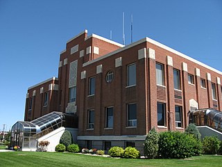
Cassia County is a county in the U.S. state of Idaho. As of the 2020 Census the county had a population of 24,655. The county seat and largest city is Burley. Cassia County is included in the Burley, ID Micropolitan Statistical Area.

Interstate 86 (I-86) is an east–west intrastate Interstate Highway located entirely within the state of Idaho. It runs approximately 63 miles (101 km) from an intersection with I-84 east of Declo in rural Cassia County, to an intersection with I-15 in Chubbuck, just north of Pocatello. The highway is part of the main route from Boise and Twin Falls to Idaho Falls and the upper Snake River region.

The Raft River is a 108-mile-long (174 km) tributary of the Snake River located in northern Utah and southern Idaho in the United States. It is part of the Columbia River Basin.

Interstate 84 (I-84) in the U.S. state of Idaho is a major Interstate Highway that traverses the state from the Oregon state line in the northwest to Utah state line in the southeast. It primarily follows the Snake River across a plain that includes the cities of Boise, Mountain Home, and Twin Falls. The highway is one of the busiest in Idaho and is designated as the Vietnam Veterans Memorial Highway.

State Highway 55 (SH-55) is an Idaho highway from Marsing to New Meadows, connecting with US-95 at both ends.

State Highway 69 (SH-69) is a 8.012-mile (12.894 km) state highway in Ada County, Idaho, United States, that connects East Avalon Street and North Orchard Avenue in Kuna with Interstate 84/U.S. Route 30/Idaho State Highway 55 (I-84/US 30/SH-55) in Meridian. SH-69 is the northern part of the Western Heritage Historic Byway, in the National Scenic Byways Program. SH-69 is a five-lane road for its entire length.

State Highway 39 (SH-39) is a 52.924-mile (85.173 km) state highway in Power and Bingham counties in Idaho, United States, that connects Interstate 86/U.S. Route 30 (I-86/US 30), northwest of American Falls with U.S. Route 26 (US 26) in Collins.

The Albion Mountains are a mountain range in the U.S. states of Idaho (~99%) and Utah (~1%), spanning Cassia County, Idaho and barely reaching into Box Elder County, Utah. The highest point in the range is Cache Peak at 10,339 feet (3,151 m), and the range is a part of the Basin and Range Province. Most of the mountains are part of the Albion Division of the Minidoka Ranger District of Sawtooth National Forest.

The Black Pine Mountains are a mountain range in the U.S. states of Idaho (~65%) and Utah (~35%), spanning Cassia County, Idaho and reaching into Box Elder County, Utah. The highest point in the range is known as Black Pine Mountains High Point, sometimes referred to as Black Peak, at 9,395 feet (2,864 m), and the range is a part of the Great Basin Divide and the Basin and Range Province. In Idaho, the mountains are part of the Black Pine Division of the Minidoka Ranger District of Sawtooth National Forest.
Black Pine Mountains High Point, at 9,289 feet (2,831 m) above sea level is the highest peak in the Black Pine Mountains of Cassia County in southern Idaho. The high point is sometimes referred to as "Black Peak" because of a benchmark on the peak that reads "Black".
The Sublett Range is a mountain range in the U.S. states of Idaho (~94%) and Utah (~6%), spanning Cassia, Oneida, and Power counties, Idaho and reaching into Box Elder County, Utah. The Phosphoria Formation reaches its greatest thickness beneath the mountains.
Strevell is a ghost town in Cassia County, Idaho, United States, approximately one mile (1.6 km) north of the Utah state line and roughly 23 miles (37 km) south–southeast of Malta. It is located in the Raft River Valley along the former routing of U.S. Route 30S, and later the former routing of Idaho State Highway 81.

State Highway 81 (SH-81) is a state highway in Cassia County, Idaho. The highway runs for 33.978 miles (54.682 km) from SH-77 in Malta to U.S. Route 30 (US-30) in Burley. It also has a short spur route connecting the highway to Interstate 84 (I-84) at the Yale Interchange.

State Highway 77 (SH-77) is a 30.676-mile (49.368 km) state highway in Cassia County, Idaho, United States, that connects Idaho State Highway 81 (SH-81) in Malta with Interstate 84/U.S. Route 30 (I-84/US 30) north of Declo, via Albion. The highway also has a spur that runs from City of Rocks Road to SH-77 in Connor.
Sublett is an unincorporated community in Cassia County, Idaho, United States, about 12 miles (19 km) east of Malta.
Sublett is an unincorporated community in Cassia County, Idaho, United States, on Idaho State Highway 81, about 2 miles (3.2 km) east–southeast of Burley.
Cassia Creek is a stream in Cassia County, Idaho, United States, that is a tributary of the Raft River.
The Jim Sage Mountains are a small mountain range in Cassia County, Idaho, United States, that are subrange of the Albion Mountains.

The Cotterel Mountains are a small mountain range in Cassia County, Idaho, United States, that are subrange of the Albion Mountains.
The Upper Raft River Valley is a valley in Cassia County, Idaho and Box Elder County, Utah in the United States.


