
Karimnagar is a city and District Headquarters in the Indian state of Telangana. Karimnagar is a major urban agglomeration and the third largest city in the state. It is governed by the Municipal Corporation and is the headquarters of the Karimnagar district. It is situated on the banks of Manair River, which is a tributary of the Godavari River. It is the third largest and fastest growing urban settlement in the state, according to the 2011 census. It has registered a population growth rate of 45.46% and 38.87% respectively over the past two decades between 1991 and 2011, which is the highest growth rate among major cities of Telangana. It serves as a major educational and health hub for the northern districts of Telangana. It is a major business center and widely known for its agricultural and granite industries, earning the nickname "City of Granites."
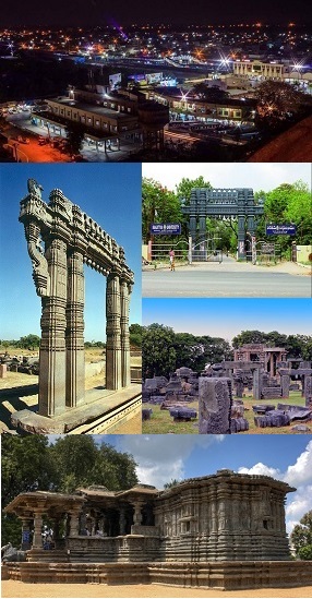
Warangal is a city in the Indian state of Telangana and the district headquarters of Warangal district. It is the second largest city in Telangana with a population of 811,844 per 2011 Census of India, and spreading over an 406 km2 (157 sq mi). Warangal served as the capital of the Kakatiya dynasty which was established in 1163. The monuments left by the Kakatiyas include fortresses, lakes, temples and stone gateways which, in the present, helped the city to become a popular tourist attraction. The Kakatiya Kala Thoranam was included in the emblem of Telangana by the state government and Warangal is also touted as the cultural capital of Telangana.

Mothkur is a Municipality and also a mandal headquarter situated in Yadadri Bhuvanagiri district in the Indian state of Telangana.It is also a Taluka ertswhile. Mothkur is located 90 kilometers away from the Telangana's capital city, Hyderabad.

Jagtial is a city in and the district headquarters of Jagtial district of Telangana state, India. Located about 190 kilometres (118 mi) north of the state capital Hyderabad, it has an average elevation of 293 metres (961 ft). In 2011 the population was about 104,000

Karimnagar district is one of the 33 districts of the Indian state of Telangana. Karimnagar city is its administrative headquarters. The district shares boundaries with Peddapalli, Jagityal, Sircilla, Siddipet, Jangaon, Hanamkonda district and Jayashankar Bhupalapally districts.

Nizamabad district is a district located in the north-western region of the Indian state of Telangana. The city of Nizamabad is the district headquarters. The district share boundaries with Jagtial, Sircilla, Nirmal, Kamareddy districts and with Nanded district of the state boundary of Maharashtra.

Hanamkonda district, is a district in the Indian state of Telangana. The district headquarters are located at Hanamakonda. The district borders the districts of Jangaon, Karimnagar, Warangal, Bhupalpally and Siddipet.
Jagirpally is a village in the Karimnagar District of Telangana, India. Coming under Saidapur Mandal, it is situated near the famous temple village Godisaala. During the Kakatiya dynasty, one of the Kakatiya senaani built the Shiva temple here. This temple came into the light during some archaeological excavations and the people believed that this temple is more famous than the Vemulavaada temple.

Bhongir, officially known as Bhuvanagiri, is a city and a district headquarters of the Yadadri Bhuvanagiri district and part of the Hyderabad Metropolitan Region of the Indian state of Telangana.
Gollapally is a village located in Gollapalle mandal of Jagtial district in Telangana, India. Before the reorganisation of districts in Telangana, Gollapally was part of Karimnagar district. And in this village there is a river named ganga
Itikial is a village in Raikal mandal, Jagtial district, Telangana, India. The village is about 65 km from the district headquarters at Jagityal, at an average elevation of 264 metres (866 ft) above sea level.
Metpally is a town and Revenue Division and third largest town in Jagtial district of the Indian state of Telangana. It is located 222 km away from state capital Hyderabad, 67 km from Nizamabad, 80 km from Karimnagar and 33 km far away from District Headquarter Jagtial. It have great history many Dynasties ruled including Sathavahana's and Kakatiya's. The Kakatiyas built a temple named Chennakesava.
Punnelu is a village in Wardhannapet mandal, Warangal district, Telangana state in India. Mohammed Abdul Khader of the village Punnelu has a very core hand in village development because of giving various lands over the areas free for the village which was his own property, for building Gramapanchayat, temple, lakes, school, Eidgah and Masjid, helping out people throughout his life, until now he is remained in the hearts of the village people for the good deeds he has done for the village and people living there.
Patharlapahad is a village in Athmakur (S) mandal, Suryapet district, state of Telangana, India. It is located along Suryapet and Warangal highway
Poodur or Pudur is a village in Kodimial mandal, Jagtial district, Telangana, India.
Mancherial district is a district located in the northern region of the Indian state of Telangana. The district comprises 18 mandals and two revenue divisions – Mancherial and Bellampalli. The district headquarters is located at Mancherial town. It is surrounded by Komaram Bheem, Nirmal, Jagtial, Peddapalli and Bhupalpally districts of Telangana and with Maharashtra state.

Nirmal district is a district located in the northern region of the Indian state of Telangana. The district headquarters is located in the town of Nirmal. It borders the Telangana districts of Adilabad, Nizamabad, Mancherial, Asifabad, Jagtial districts as well as Nanded district of the state Maharashtra.

Warangal district, formerly Warangal Rural district, is a district in the Indian state of Telangana. The district shares boundaries with Mahabubabad, Jangaon, Hanamkonda, Mulugu and Bhupalpally districts.
Jagtial district is a district located in the northern region of the Indian state of Telangana. Its administrative headquarters is the city of Jagtial. The district shares boundaries with Nirmal, Mancherial, Karimnagar, Peddapalli, Sircilla and Nizamabad districts.

Sri Venkateshwara Swamy Temple is located at the village of Allipur, Raikal mandal in Jagtial district of Telangana, India. The temple is dedicated to promoting the Hindu religion and serving the community of Allipur and surrounding villages in the region.

