
The Godavari is India's second longest river after the Ganga river and drains into the third largest basin in India, covering about 10% of India's total geographical area. Its source is in Trimbakeshwar, Nashik, Maharashtra. It flows east for 1,465 kilometres (910 mi), draining the states of Maharashtra (48.6%), Telangana (18.8%), Andhra Pradesh (4.5%), Chhattisgarh (10.9%) and Odisha (5.7%). The river ultimately empties into the Bay of Bengal through an extensive network of tributaries. Measuring up to 312,812 km2 (120,777 sq mi), it forms one of the largest river basins in the Indian subcontinent, with only the Ganga and Indus rivers having a larger drainage basin. In terms of length, catchment area and discharge, the Godavari is the largest in peninsular India, and had been dubbed as the Dakshina Ganga.

Karimnagar is also known as Elagandula is a city and District Headquarters in the Indian state of Telangana. Karimnagar is a major urban agglomeration and fifth largest City in the state. It is governed by Municipal corporation and is the headquarters of the Karimnagar district It is situated on the banks of Manair River, which is a tributary of the Godavari River.It is the third largest and fastest growing urban settlement in the state, according to 2011 census. It has registered a population growth rate of 45.46% and 38.87% respectively over the past two decades between 1991 and 2011, which is highest growth rate among major cities of Telangana. It serves as a major educational and health hub for the northern districts of Telangana. It is a major business center and widely known for its agricultural and granite industries, earning the nickname "City of Granites."

Telangana is a state in India situated on the south-central stretch of the Indian peninsula on the high Deccan Plateau. It is the eleventh-largest state and the twelfth-most populated state in India with a geographical area of 112,077 km2 (43,273 sq mi) and 35,193,978 residents as per 2011 census. On 2 June 2014, the area was separated from the northwestern part of Andhra Pradesh as the newly formed state of Telangana, with Hyderabad as its capital. Its other major cities include Warangal, Nizamabad, Khammam, Karimnagar and Ramagundam. Telangana is bordered by the states of Maharashtra to the north, Chhattisgarh to the northeast, Karnataka to the west, and Andhra Pradesh to the east and south. The terrain of Telangana consists mostly of the Deccan Plateau with dense forests covering an area of 27,292 km2 (10,538 sq mi). As of 2019, the state of Telangana is divided into 33 districts.
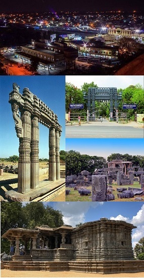
Warangal is a city in the Indian state of Telangana and the district headquarters of Warangal district. It is the second largest city in Telangana with a population of 704,570 per 2011 Census of India, and spreading over an 406 km2 (157 sq mi). Warangal served as the capital of the Kakatiya dynasty which was established in 1163. The monuments left by the Kakatiyas include fortresses, lakes, temples and stone gateways which, in the present, helped the city to become a popular tourist attraction. The Kakatiya Kala Thoranam was included in the emblem of Telangana by the state government and Warangal is also touted as the cultural capital of Telangana.

Nizamabad is also known as Induru is a city in the Indian state of Telangana. Nizamabad is a major urban agglomeration and third largest city in the state. It is governed by municipal corporation and is the headquarters of the Nizamabad district. Although previously part of Hyderabad State and then Andhra Pradesh state, Nizamabad became a part of the newly formed state of Telangana by the Andhra Pradesh Reorganisation Act, 2014.It is located about 186 kilometres (116 mi) north of the state capital, Hyderabad.

Karimnagar district is one of the 33 districts of the Indian state of Telangana. Karimnagar city is its administrative headquarters. The district shares boundaries with Peddapalli, Jagityal, Sircilla, Siddipet, Jangaon, Hanamkonda district and Jayashankar Bhupalapally districts.

Nizamabad district is a district located in the north-western region in the Indian state of Telangana. The city of Nizamabad is the district headquarters.It was known as " Indur " which was supposed to have originated from the name of the King was Indradatta who seems to have flourished it during the 5th century A.D.The district share boundaries with Jagtial, Sircilla, Nirmal, Kamareddy districts and with Nanded district of the state boundary of Maharashtra.

Hanumakonda district, is a district located in the northern region of the Indian state of Telangana. The district headquarters are located at Hanumakonda. The district borders the districts of Jangaon, Karimnagar, Warangal, Bhupalpally and Siddipet.

Ramagundam is a city and municipal corporation in Peddapalli district of the Indian state of Telangana. It is the most populous city in the district and falls under the Peddapalli revenue division. It is located on the banks of the Godavari River. As of the 2011 census, the city had a population of 229,644, making it the 6th most populous in the state, and an urban agglomeration population of 242,979. It is located about 225 km from the state capital Hyderabad.
Huzurabad is a town in the Huzurabad mandal of Karimnagar district in the Indian state of Telangana. It is a municipality in the district. It is located about 41 kilometres (25 mi) from Karimnagar and 38 kilometres (24 mi) from Warangal.

Peddapalli is a town and Revenue Division in Peddapalli District in the Indian state of Telangana. It is the headquarters of the Peddapalli District and Peddapalli mandal. It is located about 197 kilometres North of the state capital Hyderabad, 36 kilometres from Karimnagar, 28 kilometres from Ramagundam. Peddapalli has a railway junction named PDPL which connects PDPL - KRMR - NZB railway line and New Delhi (NDLS) - Chennai Central (MAS) railway line. There are two trains that terminate here. Karimnagar Tirupati express rail engine changes to electric engine here. As of 2011 census of India, Peddapalli has a population of 41,171. In 2016 due to population Increase, the civic body of Peddapalli was upgraded from Nagar Panchayat to Municipal council Post upgradation to Council.

Ghatkesar is a satellite town of Hyderabad in the Medchal-Malkajgiri district of Telangana, India. It is the Mandal headquarters of Ghatkesar Mandal in The Keesara revenue division. Located in the outer suburbs of Hyderabad, it is a part of The Hyderabad Metropolitan Development Authority.
Namasthe Telangana Indian Telugu-language daily newspaper published from Hyderabad, Telangana. It was launched on 6 June 2011. The paper aims to mainly focus on politics and developments of Telangana State. The newspaper is published by Telangana Publications Pvt. Limited, owned by K. Chandrashekar Rao, the current chief minister of Telangana.

The Karimnagar Municipal Corporation is the local governing body, administering the city of Karimnagar in the Indian state of Telangana. It is the fourth most populous city in Telangana with a population of 260,899. The municipal corporation is headed by a mayor and democratically elected members.
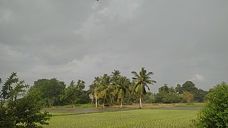
Palem is a village in Morthad mandal belongs to Nizamabad district in the Telangana state. It is located 50 km towards east from district headquarters Nizamabad. 4 km from Morthad. The main occupation of the people in the village is agriculture, whereas they grow many crops like paddy, groundnuts, turmeric, maize, soybean etc.. Palem Pin code is 503225 and postal head office is Morthad. There is a bank named State Bank of INDIA with the branch code as 020738 and the IFSC Code as SBIN0020738 This place is in the border of the Nizamabad District and Karimnagar District. Karimnagar District Metpalli is east towards this place. Telugu is the local language here. Total population of Palem is 3410. Males are 1680 and Females are 1,730 living in 774 Houses. Total area of Palem is 1860 hectares. ZPHS Palem(Government School) won the best school of the state award for the year 2015 from Telangana Government - CM K. Chandrashekar Rao.

Gellu Srinivas Yadav is a Telangana Rashtra Samithi politician from Telangana state in India. He is currently the state president of the student wing of the Telangana Rashtra Samithi. TRS Party has named Gellu Srinivas Yadav as the party candidate for the Huzurabad by-election. He was defeated by Eatala Rajender of the Bharatiya Janata Party (BJP), in the end losing by 23855 votes.

Kothapalli (Haveli) (Telugu: కొత్తపల్లి), or Kothapalli, is a Revenue Village and a semi-town in Kothapalli Mandal, Karimnagar district, Telangana, India. The village used to be in the Karimnagar mandal of the old Karimnagar district. Following the district reorganization of Telangana, it was included in the newly formed Kothapalli Mandal. Kothapalli was formed as a municipal corporation on August 2, 2018, as part of the Municipal Amendment Bill by the Government of Telangana.

