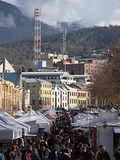
Salamanca Place is a precinct of Hobart, the capital city of the Australian state of Tasmania.

The Brooker Highway is a highway in the State of Tasmania, Australia. As one of Hobart's 3 major radials, the highway connects traffic from the Hobart city centre with the northern suburbs and is the major road connection to the cities and towns of Northern Tasmania. With an AADT of 48,000, the highway is one of the busiest in Tasmania. The Brooker Highway has recently been declared part of the National Highway.

Sullivans Cove is on the River Derwent adjacent to the Hobart CBD in Tasmania.

Davey Street a major one way street passing through the outskirts of the Hobart Central business district in Tasmania, Australia. Davey street is named after Thomas Davey, the first Governor of Van Diemen's Land. The street forms a One-way couplet with nearby Macquarie Street connecting traffic from the Southern Outlet in the south with traffic from the Tasman Highway to the east and the Brooker Highway to the north of the city. With Annual average daily traffic of 37,200, the road is one of the busier streets in Hobart.
Shoreline Plaza is a suburban shopping centre located on the corner of Clarence St and South Arm Highway in the suburb of Howrah on Hobart's Eastern Shore.
Macquarie Street a major one way street passing through the outskirts of the Hobart Central business district in Tasmania, Australia. Macquarie street is named after Lachlan Macquarie, who oversaw the planning of Hobart’s inner city grid layout. The street forms a One-way couplet with nearby Davey Street connecting traffic from the Southern Outlet in the south with traffic from the Tasman Highway to the east and the Brooker Highway to the north of the city. With annual average daily traffic of 28,500, the road is one of the busier streets in Hobart.

Hobart Library, also known as the State Library of Tasmania, is the main library and headquarters of the library system known as Libraries Tasmania, in the state of Tasmania, Australia.

The Royal Hobart Regatta began in 1838, is a series of aquatic competitions and displays held annually in Hobart, Tasmania, Australia and is Tasmania's oldest sporting event. The regatta runs for three days, ending on the second Monday in February, and dominates the whole river for the duration of the event. The regatta of 6 February 1934 was the first to be called the Royal Hobart Regatta, the title being conferred by King George V.

The Hobart Bus Mall is a section of Elizabeth Street which serves as Metro Tasmania's primary bus terminus in Hobart's CBD. It is utilised by thousands of commuters every day, bringing city workers into Hobart from outlying suburbs, and the neighbouring cities of Clarence and Glenorchy, as well as nearby Richmond, Cambridge and Kingborough. The mall is the section of Elizabeth Street, located between Macquarie Street, and Collins Street. There are also several stops located in nearby Franklin Square.

Goodwood Road is a 4-lane link road that connects the City of Glenorchy to the City of Clarence in the greater area of Hobart, Tasmania. Using the Bowen Bridge the road travels over the River Derwent in semi-highway road layout. The Road starts 10 km north of the Hobart CBD near the Hobart Showground on the Brooker Highway at Glenorchy, from there it travels east past the Elwick Racecourse, over the Bowen Bridge and connects to the East Derwent Highway at Otago. While the route the road takes is used far less than other major arterial roads in Hobart, commuters often depend on the road when major incidents occur on other major roads throughout Hobart.
Elwick Road is a major arterial road that runs through the northern suburbs of Hobart, Tasmania. The Road is the major link road between the Main Road and the Brooker Highway that connects to Glenorchy. The Road Passes through residential areas.
The Rhyndaston Tunnel is a 955-metre-long, 1-in-40-grade (2.5%) railway tunnel in southern Tasmania. The northern end of the tunnel is 72.5 km from the Hobart railway yards. It was built as part of the Tasmanian Main Line Company's track from Hobart to Western Junction which was completed in 1876.
The Kingston Interchange is a roundabout interchange which connects the Southern Outlet with the Huon Highway and the Channel Highway at Kingston, within the greater area of Hobart, Tasmania.

Smooth Island, is a privately owned island with an area of 59.31 ha lying close to the south-eastern coast of Tasmania, Australia. The island is part of the Sloping Island Group situated in Norfolk Bay and surrounded by the Tasman and Forestier Peninsulas. The towns Dunalley and Murdunna are nearby. Smooth Island differs from other Tasmanian islands as it has an unencumbered freehold title down to the high-water mark.

Hobart City Centre is a suburb surrounded by metropolitan Hobart, which comprises the original settlement, the central business district, and other built-up areas. It is the oldest part of Hobart and includes many of the city's important institutions and landmarks, such as Parliament, the Supreme Court, Franklin Square, the Elizabeth Street Mall, the Royal Hobart Hospital, the Theatre Royal, State Library, the NAB Building, the Museum, and the Cenotaph. The city centre is located in the local government areas of the City of Hobart.

Victoria Dock, in Hobart, Tasmania, Australia, is a key dock for Australian Antarctic supply vessels and one of the oldest docks in Tasmania.

Old Government House was the former official residence and home of the Governor of Tasmania from 1807 to 1858, when it was demolished following completion of the modern Government House, Hobart on the Queens Domain. It was located approximately where Hobart Town Hall and Franklin Square stand now. It was built sometime between 1805 and 1810 with dates varying according to sources and at least during 1831 housed the Tasmanian Parliament as well as being the residence of the Governor and meeting place of the Tasmanian Society, a precursor to the Royal Society of Tasmania. The Tasmanian Parliament moved to the modern Parliament House, Hobart in 1841, and following the construction of the modern Government House the old house was demolished. It had earlier been reserved for the location of the new Town hall and a Franklin monument, which were both later built there and continue to stand to this day.

The Hope and Anchor Tavern is an Australian pub in Hobart, Tasmania. Built in 1807, it is claimed to be the oldest Australian pub, having continually operated until 2008. However, The Bush Inn in New Norfolk claims to be the oldest operating Australian pub, because their venue has operated continuously since it opened in 1815 whereas the Hope and Anchor Tavern has had periods of closure since opening in 1807. The Hope and Anchor Tavern is referred to in 'Captain A E Sykes: memoirs'

Elizabeth Street Mall is a pedestrian street mall in Hobart, Tasmania. It is located on Elizabeth Street between Collins Street and Liverpool Street. It is the largest shopping area in the Hobart city centre. It is also a busy meeting place and busking area.
Holy Trinity Church is a former Anglican, and now Greek Orthodox, church in North Hobart, Tasmania.