Rainbow Falls (Chelan County)

Last updated
Rainbow Falls

Rainbow Falls near Stehekin Washington.JPG

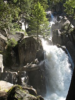
Rainbow Falls with moderate flow viewed from bottom on north shore
Location Chelan County, Washington, United States
Coordinates 48°20′38″N120°41′56″W / 48.344°N 120.699°W / 48.344; -120.699 Coordinates: 48°20′38″N120°41′56″W / 48.344°N 120.699°W / 48.344; -120.699
Type Tiered
Total height 392 feet (119.5 m)
Number of drops 2
Longest drop 312 feet (95.1 m)
Total width 15 feet (4.6 m)
Watercourse Rainbow Creek

Rainbow Falls is a waterfall on Rainbow Creek in the U.S. state of Washington. [1] The waterfall is located inside the Lake Chelan National Recreation Area in the North Cascades National Park, and is near Stehekin. The falls drops 392 feet (119.5 m) in two tiers. The uppermost tier falls 312 feet (95.1 m) to a basin. [2]

Washington (state) State of the United States of America

Washington, officially the State of Washington, is a state in the Pacific Northwest region of the United States. Named for George Washington, the first president of the United States, the state was made out of the western part of the Washington Territory, which was ceded by Britain in 1846 in accordance with the Oregon Treaty in the settlement of the Oregon boundary dispute. It was admitted to the Union as the 42nd state in 1889. Olympia is the state capital; the state's largest city is Seattle. Washington is sometimes referred to as Washington State to distinguish it from Washington, D.C., the capital of the United States.

Lake Chelan National Recreation Area

Lake Chelan National Recreation Area is a U.S. National Recreation Area (NRA) located about 35 miles (56 km) south of the Canada–US border in Chelan County, Washington. It encompasses an area of 61,958 acres (25,074 ha) including the northern end of Lake Chelan and the surrounding area of the Stehekin Valley and the Stehekin River. The area is managed by the U.S. National Park Service as part of the North Cascades National Park Service Complex.

North Cascades National Park U.S. National Park located in the state of Washington

North Cascades National Park is an American national park in the state of Washington. At more than 500,000 acres (200,000 ha), North Cascades National Park is the largest of the three National Park Service units that comprise the North Cascades National Park Complex. North Cascades National Park consists of a northern and southern section, bisected by the Skagit River that flows through Ross Lake National Recreation Area. Lake Chelan National Recreation Area lies on the southern border of the south unit of the park. In addition to the two national recreation areas, other protected lands including several national forests and wilderness areas, as well as Canadian provincial parks in British Columbia, nearly surround the park. North Cascades National Park features the rugged mountain peaks of the North Cascades Range, the most expansive glacial system in the contiguous United States, the headwaters of numerous waterways, and vast forests with the highest degree of flora biodiversity of any American national park.

The waterfall is accessible from a series of trails maintained by the National Park Service and is easily visible from the Stehekin Valley Road. During the summer months a National Park Service shuttle provides regular transport from the Stehekin dock to Rainbow Falls. [3]

National Park Service United States federal agency

The National Park Service (NPS) is an agency of the United States federal government that manages all national parks, many national monuments, and other conservation and historical properties with various title designations. It was created on August 25, 1916, by Congress through the National Park Service Organic Act and is an agency of the United States Department of the Interior. The NPS is charged with a dual role of preserving the ecological and historical integrity of the places entrusted to its management, while also making them available and accessible for public use and enjoyment.

Related Research Articles

Iguazu Falls waterfalls in Brazil and Paraguay

Iguazú Falls or Iguaçu Falls are waterfalls of the Iguazu River on the border of the Argentine province of Misiones and the Brazilian state of Paraná. Together, they make up the largest waterfall system in the world. The falls divide the river into the upper and lower Iguazu. The Iguazu River rises near the heart of the city of Curitiba. For most of its course, the river flows through Brazil; however, most of the falls are on the Argentine side. Below its confluence with the San Antonio River, the Iguazu River forms the boundary between Argentina and Brazil.

Waterfall Place where water flows over a vertical drop in the course of a river

A waterfall is an area where water flows over a vertical drop or a series of steep drops in the course of a stream or river. Waterfalls also occur where meltwater drops over the edge of a tabular iceberg or ice shelf.

Multnomah Falls waterfall in Oregons Columbia Gorge

Multnomah Falls is a waterfall located in the Columbia River Gorge, east of Troutdale, between Corbett and Dodson, Oregon, United States. The waterfall is accessible from the Historic Columbia River Highway and Interstate 84. Spanning two tiers on basalt cliffs, it is the tallest waterfall in the state of Oregon at 620 ft (189 m) in height.

Stehekin, Washington human settlement in Washington, United States of America

Stehekin is a small unincorporated community in Chelan County, Washington. It is part of Wenatchee–East Wenatchee Metropolitan Statistical Area. Located at the northwest end of Lake Chelan, it lies just south of the North Cascades National Park. It is within Lake Chelan National Recreation Area, a unit administered by the National Park Service. Stehekin has about 75 permanent residents, though its population swells during the summer with vacationers and seasonal workers. The name "Stehekin" comes from a Native American word meaning "the way through."

Akaka Falls State Park

ʻAkaka Falls State Park is a state park on Hawaiʻi Island, in the U.S. state of Hawaii.

Yellowstone Falls waterfall

Yellowstone Falls consist of two major waterfalls on the Yellowstone River, within Yellowstone National Park, Wyoming, United States. As the Yellowstone river flows north from Yellowstone Lake, it leaves the Hayden Valley and plunges first over Upper Yellowstone Falls and then a quarter mile downstream over Lower Yellowstone Falls, at which point it then enters the Grand Canyon of the Yellowstone, which is up to 1,000 feet deep.

Stehekin River watercourse in the United States of America

The Stehekin River is a river located in Washington state in the Pacific Northwest of the United States. It is the main river flowing into Lake Chelan. Miners arrived in Stehekin River Valley in the late 19th century. They were followed by homesteaders in the early 20th century. Today, the Stehekin River Valley is still a remote area that can only be reached by way of a 55-mile boat ride up Lake Chelan.

Chilnualna Falls waterfall

Chilnualna Falls is a series of waterfalls totaling 690 feet, located on Chilnualna Creek in the southern section of Yosemite National Park.

Wallace Falls State Park Washington state park

Wallace Falls State Park is a public recreation area that encompasses 1,380 acres (560 ha) along the Wallace River in Snohomish County, Washington. The state park is located on the west side of the Cascade Mountains with an entrance point one mile (1.6 km) northeast of the community of Gold Bar. The park features three waterfalls, three backcountry lakes, old-growth coniferous forests, rushing mountain rivers and streams, and the evidence of its logging history in the ruins of railroad trestles, disused railroad grades, and springboard notches in stumps.

Silver Falls State Park

Silver Falls State Park is a state park in the U.S. state of Oregon, located near Silverton, about 20 miles (32 km) east-southeast of Salem. It is the largest state park in Oregon with an area of more than 9,000 acres (36 km2), and it includes more than 24 miles (39 km) of walking trails, 14 miles (23 km) of horse trails, and a 4-mile (6.4 km) bike path. Its 8.7-mile (14.0 km) Canyon Trail/Trail of Ten Falls runs along the banks of Silver Creek and by ten waterfalls, from which the park received its name. Four of the ten falls have an amphitheater-like surrounding that allows the trail to pass behind the flow of the falls. The Silver Falls State Park Concession Building Area and the Silver Creek Youth Camp-Silver Falls State Park are separately listed on the U.S. National Register of Historic Places.

Rainbow Falls is the name of several waterfalls:

Rainy Lake Falls is a waterfall on the inlet stream of namesake Rainy Lake in Chelan County, Washington. The stream heads in a pair of small lakes and the remaining portions of the Lyall Glacier, and flows down a cascade that is said to be approximately 850 feet (260 m) high.

Mazama Falls, also referred to more simply as Wells Creek Falls, is a waterfall on Wells Creek in the U.S. state of Washington. At nearly 500 feet (150 m) high, it is said to be the largest waterfall in the Wells Creek watershed.

Narada Falls waterfall

Narada Falls is a waterfall in Mount Rainier National Park, in the U.S. state of Washington. It is said to be the most popular, because the Mount Rainier Highway crosses the falls between its two tiers.

Salt Creek Falls waterfall

Salt Creek Falls is a cascade and plunge waterfall on Salt Creek, a tributary of the Middle Fork Willamette River, that plunges into a gaping canyon near Willamette Pass in the Willamette National Forest, near Oakridge, Oregon. The waterfall is notable for its main drop of 286 feet (87 m) which makes it the third highest plunge waterfall in Oregon after Multnomah Falls and Watson Falls the second highest, which was re-measured in 2009 and found to be 293 feet rather than an earlier measurement of 272 feet passing Salt Creek Falls. The pool at the bottom of the waterfall is 20 metres (66 ft) deep.

Rainbow Falls (California)

Rainbow Falls is the highest waterfall on the Middle Fork of the San Joaquin River, in the eastern Sierra Nevada mountains of California, in the United States. Plunging 101 feet (31 m) to the turbulent water below, the falls are named for the rainbows that appear in their mist on sunny summer days. Rainbow Falls is located within the boundaries of Devils Postpile National Monument.

Tumalo Falls

Tumalo Falls is a 97-foot (30 m) waterfall on Tumalo Creek, in the Cascade Range west of Bend in the U.S. state of Oregon. Additional waterfalls are upstream along Tumalo Creek and a tributary, Bridge Creek and its Bridge Creek Falls. All of these falls are within the Deschutes National Forest.

Duwee Falls is a steep tiered waterfall on Munson Creek, a tributary of the Klamath River, that plunges into a gaping canyon within the Crater Lake National Park in the U.S. state of Oregon. The waterfall is notable for its main drop of 100 feet (30 m) which makes it the highest plunge waterfall in Crater Lake Park.

References

  1. "Rainbow Falls". Geographic Names Information System (GNIS), U.S. Geological Survey. September 10, 1979. Retrieved March 11, 2017.
  2. "Rainbow Falls". Aaron's Waterfall World. Retrieved March 11, 2017.
  3. https://www.nps.gov/noca/planyourvisit/stehekin-transportation.htm