Adavad, also spelled Adawad or Adwad, is a village in the Chopda Tehsil of Jalgaon District, Maharashtra, India. It is situated at the southern base of the Satpura Hills, about 30 kilometres northwest of the district seat Jalgaon, and 13 kilometres east of the subdistrict seat Chopda. As of the year 2011, it has a total population of 24,357.
Nitte is a village in Karkala Taluk, Udupi District, Karnataka, India. It is located on the way from Padubidri to Karkala, about 26 kilometres southeast of the district capital Udupi, and 7 kilometres southwest of the taluka capital Karkala. In the year 2011, the village is home to 12,354 inhabitants.

Wandoor is a town in Nilambur Taluk, Malappuram District, Kerala, India. It is located on the southeast of Chaliyar River, about 24 kilometres northeast of the district seat Malappuram, and 8 km south of the taluk seat Nilambur. In the year 2011, the town has a population of 50,973.

Thevalakkara is a village in the Karunagappally Taluk, Kollam District of the state of Kerala, India. It is located near the coast of the Indian Ocean, about 13 kilometres north of the district capital Kollam, and 7 kilometres southeast of the subdistrict capital Karunagappally. It contains a famouse Devi temple along with a church and a mosque. The kadappa at Thevalakara is where ship masts (kadappa) were made for centuries. In 2011, it has a total population of 42,977.
Chinchali is a village in Raybag Taluk, Belagavi District, Karnataka, India. It is located near the state boundary with Maharashtra, approximately 84 kilometres north of the district seat Belgaum, and 10 kilometres northeast of the taluk seat Raibag. In the year 2011, the village has a population of 18,986.
Mohare is a village in Bailhongal Taluk, Belagavi District of Karnataka, India. It is located near the state border with Maharashtra, about 26 kilometres east of the district seat Belgaum, and 16 kilometres northwest of the taluk seat Bailhongal. As of 2011, it has a total population of 2,365.
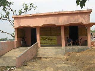
Kubauli,(Urdu : کوبولی)(Hindi:कुबौली )(pronunciation ) also known as Kubauli Dhala, is a village located in the Muzaffarpur District of Bihar state, India. The village, situated about 47 km west of Muzaffarpur city, has a population of around 2,260.
Sarti is a village in Dhar Kalan Tehsil, Gurdaspur District, Punjab, India. It is located 68 kilometres northeast of its district capital Gurdaspur, and 8 kilometres north of Dhar Kalan. As of the year 2011, its population is 3,960.
Badavanahalli is a village within Madhugiri Taluk, Tumakuru District, Karnataka, India. It is located at 37 kilometres north of the district seat Tumkur, and 16 kilometres west of the subdistrict seat Madhugiri. In the year 2011, it has a total population of 4,332.

Satar Kataiya, or Sattar Kataiya, is a tehsil of Saharsa District, Bihar, India. Its seat of government is located in the village of Sattar. As of the year 2011, its population is 151,060.
Parham is a village in Jasrana Tehsil, Firozabad District, Uttar Pradesh, India. As of the year 2011, it has a population of 19,642.
Tirthpuri is a village in Ghansawangi Taluka, Jalna district, Maharashtra, India. According to the 2011 Census of India, it is home to 10,148 residents.
Gachirampara is a village in Dasda Block, North Tripura District, Tripura, India. It borders Dasda Laxmipur to the north, Paschim Tlangsanbari (Part) to the east, Lambachhara to the south, and Ramprasaipara to the west. In the year 2011, it has a total population of 21,601.
Chahardi is a village in Chopda Taluka, Jalgaon District, Maharashtra, India. It is located at the north of Tapti River, approximately 44 kilometres northwest of the district seat Jalgaon, and 8 kilometres southwest of the subdistrict seat Chopda. As of the year 2010, it has a total population of 11,115.
Aurai is a block of Muzaffarpur District, Bihar, India. Its administrative center is the village of Aurai. As of 2011, the block has a total population of 290,545.
Dhamdaha is a village and the administrative division of Dhamdaha Block, Purnia District, Bihar, India. It is situated in the Eastern part of Bihar, about 26 kilometres southwest of the block capital Purnia. In the year 2011, the village has a total population of 37,987.
Nigohi is a town in Tilhar Tehsil, Shahjahanpur District, Uttar Pradesh, India. It is situated on the northern part of Shahjahanpur District, about 25 kilometres north of the district capital Shahjahanpur, and 20 kilometres northeast of the tehsil capital Tilhar. In the year 2011, the town has a population of 18,523.
Jale, or Jalley, is a town and the administrative center of Jale Block, Darbhanga District, Bihar, India. It is located to the north of Bagmati River, about 32 kilometres northwest of the district capital Darbhanga. The town was named after Jaleshwari sthan which is a pilgrimage site in rural area of Darbhanga. In the year 2011, it has a total population of 37,256.
Thakraha, or Thakrahan, is a town and the seat of government of Thakrahan Block, Pashchim Champaran, Bihar, India. It is located near the state border with Uttar Pradesh, about 25 kilometres west of the district seat Bettiah. In the year 2011, the town has a total population of 35,734.
Morai is a village in Ambattur Taluk, Tiruvallur District, Tamil Nadu, India. It is located in the western suburb of Chennai, about 23 kilometres away from the city center. As of 2011, it had a total population of 10,873.


