Rajgir Hills

Last updated

Rajgir Hills
Rajgir 11 Vipula Hill (30707784594).jpg
Rajgir hills
Highest point
Peak388 m
Elevation 200–388 m (656–1,273 ft)
Coordinates 25°00′14″N85°24′06″E / 25.003808854167087°N 85.40156083554832°E / 25.003808854167087; 85.40156083554832
Dimensions
Length65 km (40 mi)
Geography
Bihar relief map.svg
Red triangle with thick white border.svg
Rajgir Hills
Rajgir Hill
Location Rajgir, Bihar, India

The Rajgir Hills, also known as "Rajgriha" hills, lie near the city of Rajgir in central regions of the Indian state of Bihar. It is surrounded by five hills named Ratnagiri, Vipulachal, Vaibhavagiri, Songiri and Udaygiri. It is an important Buddhist, Hindu and Jain pilgrimage site. [1]

Contents

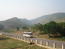
The hills consist of two parallel ridges extending around 65 km. At their highest point, the hills rise to an altitude of 388 meters, but most of the hills are around 300 meters high. Between these two ridges lie a number of places of historical importance, dating from the period of the Mahabharata, Shraman Bhagwan Mahavira, Gautam Buddha, Mauryas and the Guptas. The hills are sacred in both Buddhism and Jainism because of their association with the religions' respective founders, the historical Shraman Bhagwan Mahavira and Gautama Buddha. Therefore, the hills have often been the destination of religious pilgrimage for Jains and Hindus alike. There are multiple tourist spots spread around rajgir hills. [2]

Because the spot was protected by two parallel ridges, Ajatashatru made it the capital of the east Indian empire Magadha in the 5th century BCE, naming it Rajgriha. Ajatashatru occupied the throne by imprisoning his father, the king Bimbisara. Bimbisara, who had been converted to Buddhism by the Buddha himself, requested that his prison be constructed near a small hillock so that he could watch the Buddha passing by in the morning and evening.

In modern day, visitors can follow a ropeway to the top of the hill to visit the Buddhist Shrine, Peace Pagoda, near where the Buddha is believed to have preached the Lotus Sutra. On the descent, viewers can see the Vulture's Peak (Gridhra-kuta), where Buddha was said to have rested after the day's preaching. [3]

About four kilometers from Peace Pagoda is the Brahma Kund [4] (one of several sacred sites throughout India of the same name). Here, hot water from seven different springs (together called Saptarshi, or seven sages) merge. The Brahma Kund is associated with healing power, likely due to the sulfur in the hot springs. There are also hot springs like surya kund which is famous for repair skin disease. There is also akhara of king Jarasandh. It also has many Jain and Buddhist temples, including Naulakha Mandir, Lal mandir and Virayatan.

Pant Wildlife Sanctuary was created in 1978, and protects an area of 35.84 km2. [5]

Places

See also

Related Research Articles

<span class="mw-page-title-main">Mahavira</span> Final tirthankara of Jainism

Mahavira, also known as Vardhamana, was the 24th Tirthankara of Jainism. He was the spiritual successor of the 23rd Tirthankara Parshvanatha. Mahavira was born in the early 6th century BCE into a royal Jain family of ancient India. His mother's name was Trishala and his father's name was Siddhartha. They were lay devotees of Parshvanatha. Mahavira abandoned all worldly possessions at the age of about 30 and left home in pursuit of spiritual awakening, becoming an ascetic. Mahavira practiced intense meditation and severe austerities for twelve and a half years, after which he attained Kevala Jnana (omniscience). He preached for 30 years and attained moksha (liberation) in the 6th century BCE, although the year varies by sect.

<span class="mw-page-title-main">Magadha</span> Empire in ancient India

Magadha also called the Kingdom of Magadha or the Magadha Empire, was a kingdom and empire, and one of the sixteen Mahajanapadas, 'Great Kingdoms' of the Second Urbanization, based in southern Bihar in the eastern Ganges Plain, in Ancient India. Magadha was ruled by the Brihadratha dynasty, the Haryanka dynasty, the Shaishunaga dynasty, the Nanda dynasty, the Mauryan dynasty, the Shunga dynasty and the Kanva dynasty. It lost much of it territories after being defeated by the Satavahanas of Deccan in 28 BC and was reduced to a small principality around Pataliputra. Under the Mauryas, Magadha became a pan-Indian empire, covering large swaths of the Indian subcontinent and Afghanistan.

<span class="mw-page-title-main">Bimbisara</span> Haryanka dynasty king of Magadha (c.558–c.491 BCE)

Bimbisāra or རྒྱལ་པོ་གཟུགས་ཅན་སྙིང་པོ་ (Tibetan) or Shrenika and Seniya in the Jain histories was the King of Magadha and belonged to the Haryanka dynasty. He was the son of Bhattiya. His expansion of the kingdom, especially his annexation of the kingdom of Anga to the east, is considered to have laid the foundations for the later expansion of the Mauryan Empire.

<span class="mw-page-title-main">Ajatashatru</span> King of Magadha from c. 492 to 460 BCE

Ajatasattu or Ajatashatru in Buddhist tradition, or Kunika and Kuniya in the Jain histories, was one of the most important kings of the Haryanka dynasty of Magadha in East India. He was the son of King Bimbisara and was a contemporary of both Mahavira and Gautama Buddha. He forcefully took over the kingdom of Magadha from his father and imprisoned him. He fought a war against the Vajjika League, led by the Licchavis, and conquered the republic of Vaishali. The city of Pataliputra was formed by fortification of a village by Ajatashatru.

<span class="mw-page-title-main">Rajgir</span> Town in Bihar, India

Rajgir, meaning "The City of Kings," is a historic town in the district of Nalanda in Bihar, India. As the ancient seat and capital of the Haryanka dynasty, the Pradyota dynasty, the Brihadratha dynasty and the Mauryan Empire, as well as the dwelling ground of such historical figures as The Buddha and The Mahavira, the city holds a place of prominence in Hindu, Buddhist and Jain scriptures. As of 2011, the population of the town was reported to be 41,000 while the population in the community development block was about 88,500.

Wardha is a city and a municipal council in Wardha district in the Indian state of Maharashtra. The administrative headquarter of Wardha district is situated here. Wardha gets its name from the Wardha River which flows on the northern, western and southern boundaries of the district. Founded in 1866, the town is now an important centre for cotton trade. Wardha was an important part of the Gandhian era.

<span class="mw-page-title-main">Pawapuri</span> Town in Bihar, India

Pawapuri or Pavapuri is a holy site for Jains located in the Nalanda district of Bihar state in Eastern India. It is located about 19 kilometers from Rajgir and 101 kilometers from Patna, the capital of Bihar. Pawapuri is the place of Mahavira's nirvana and a pilgrimage site for Jains.

<span class="mw-page-title-main">Bihar Sharif</span> Sub-metropolitan city in Bihar, India

Bihar Sharif is the headquarters of Nalanda district and the fifth-largest sub-metropolitan area in the eastern Indian state of Bihar. Its name is a combination of two words: Bihar, derived from vihara, also the name of the state; and Sharif. The city is a hub of education and trade in southern Bihar, and the economy centers around agriculture supplemented by tourism, the education sector and household manufacturing. The ruins of the ancient Nalanda Mahavihara, a UNESCO World Heritage Site, are located near the city.

<span class="mw-page-title-main">Peace Pagoda</span> Buddhist stupa; a monument to inspire peace

A Peace Pagoda is a Buddhist stupa: a monument to inspire peace, designed to provide a focus for people of all races and creeds, and to help unite them in their search for world peace. Most, though not all, peace pagodas built since World War II have been built under the guidance of Nichidatsu Fujii (1885–1985), a Buddhist monk from Japan and founder of the Nipponzan-Myōhōji Buddhist Order. Fujii was greatly inspired by his meeting with Mahatma Gandhi in 1931 and decided to devote his life to promoting non-violence. In 1947, he began constructing Peace Pagodas as shrines to world peace. The first was inaugurated at Kumamoto in 1954.

<span class="mw-page-title-main">Nalanda district</span> District in Bihar, India

Nalanda district is one of the thirty-eight districts of the state of Bihar in India. Bihar Sharif is the administrative headquarters of this district. The districts is home to the ancient Nalanda Mahavihara a UNESCO World Heritage Site. Nalanda is located in the Magadh region of southern Bihar.

<span class="mw-page-title-main">Vajjika League</span> Republican confederacy in ancient India

The Vajjika or VrijikaLeague, Confederacy, or Sangha, also called simply Vajji or Vriji, was an ancient Indo-Aryan tribal league which existed during the later Iron Age period in north-east South Asia.

<span class="mw-page-title-main">Mangi-Tungi</span> Twin-pinnacled peak in Maharashtra, India

Mangi-Tungi is a prominent twin-pinnacled peak with plateau in between, located near Tahrabad about 125 km from Nashik, Maharashtra, India. Mangi, 4,343 ft (1,324 m) high above sea level, is the western pinnacle and Tungi, 4,366 ft (1,331 m) high, the eastern. Mangi-Tungi is 30 km (19 mi) from the city of Satana.

<span class="mw-page-title-main">Vaishali (ancient city)</span> Historical city in Bihar, India

Vaishali, Vesali or Vaiśālī was a city in present-day Bihar, India, and is now an archaeological site. It is a part of the Tirhut Division.

<span class="mw-page-title-main">Tourism in Bihar</span>

The state of Bihar in eastern India, is one of the oldest inhabited places in the world with a history going back 3000 years. The rich culture and heritage of Bihar is evident from the innumerable ancient monuments that are dotted all over the state. Bihar is home to many tourist attractions and is visited by large numbers of tourists from all over the world. Around total 6 million tourists visit Bihar every year.

Hinduism is the most followed religion in Bihar, followed by nearly 82.7% of total population as per 2011 Census. Islam is the second-most followed religion which is followed by nearly 16.8% of population. There is also a significant population of Jains and Christians in the state.

<span class="mw-page-title-main">Saptaparni Cave</span>

Saptparni Cave, also referred to as Sapta parni guha (Saraiki) or sattapaṇṇi guhā (Pali), literally Seven-leaves-cave, is a Buddhist cave site about 2 kilometres (1.2 mi) southwest from Rajgir, Bihar, India. It is embedded in a hill. The Saptaparni Cave is important in the Buddhist tradition, because many believe it to be the site in which Buddha spent some time before his death, and where the first Buddhist council was held after Buddha died (paranirvana). It is here that a council of few hundred monks decided to appoint Ananda, Buddha's cousin, and Upali, who had accompanied the Buddha when he gave sermons in north India, to compose Buddha's teachings for the future generations. This was of special importance because the Buddha never wrote down his teachings. After the meeting in Saptaparni Cave, Ananda created an oral tradition of Buddha's teaching from his memory, prefacing it with "Thus have I heard on one occasion". Upali is credited with reciting the Vinaya (discipline), or "rules for the Bhikshus". This tradition is found in Vinaya Pitaka II.284 through II.287 and Digha Nikaya II.154.

<span class="mw-page-title-main">Vishwa Shanti Stupa, Rajgir</span>

Vishwa Shanti Stupa is a large white Peace Pagoda in Rajgir, Nalanda District, Bihar, near Gitai Mandir. Statues of the Buddha are mounted on the stupa in four directions. It also has a small Japanese Buddhist temple with a large park. There is a temple near the stupa where prayers are conducted for universal peace. The initial pagoda was completed in 1969. New initiatives in 1993 resulted in the present form. It is one of around 80 Peace Pagodas which have been built around the world by the neo-Buddhist organisation Nipponzan Myohoji. These were a dream of Nichidatsu Fujii, inspired by Mohandas K. Gandhi, as a reaction to the atomic bombing of Japan, the first, and more well known Vishwa Shanti stupa, being built on Ratnagiri Hill in Rajgir.

<span class="mw-page-title-main">48 kos parikrama</span> Hindu Pilgrimage

The 48 kos parikrama is a parikrama of various Mahabharata-related and other Vedic-era tirthas around the holy city of Kurukshetra in the state of Haryana, India.

<span class="mw-page-title-main">Aerial lift in India</span>

The ropeway in India is a public transportation system where cabins, gondolas or open chairs are hauled above the ground with the help of cables. India's Parvatmala Scheme, the world's largest ropeway project, envisages spending 1,250 billion (US$16 billion) in public–private partnership (PPP) mode over five years till 2030 to build 200 new ropeway projects of more than 1200 km length, which will decongest the traffic in narrow roads of big cities and provide cheaper connectivity in mountainous and touristy areas. Since 30% of India is covered by mountains, the ropeways are specially useful in mountainous areas, where it is difficult to build roads or railway, as lower cost and higher Return on investment (ROI) projects. Rajgir Ropeway in Bihar, 333m-long chairlift ropeway built in 1960s, is India's first ropeway. As of 2024, the 4km-long Auli Ropeway in Uttarakhand is India's longest and world's the second-longest ropeway behind Vietnam's 7,899.9 m long Hòn Thơm cable car, and when completed the under-construction 5.5km-long Mussoorie-Dehradun Ropeway will be the longest in India. Kashi ropeway is India's first urban ropeway, and world's third urban public transport ropeway behind Bolivia's Mi Teleférico opened in 2014 and Mexico City's Mexicable opened in 2021. This article also contains a list of "glass bridges in India", which are mostly glass bridge skywalk.

References

  1. "Rajgir Hills". Encyclopædia Britannica. Retrieved 10 September 2014.
  2. "Rajgir Tourist Places to Visit, Rajgir Best Tourist Spots and Sightseeing". Travel News India. 22 August 2016. Retrieved 26 February 2017.
  3. "Rajgir". Bihar State Tourism IDevelopment Corporation. Archived from the original on 1 September 2014. Retrieved 10 September 2014.
  4. "Google Maps". Google Maps. Retrieved 16 November 2016.
  5. UNEP-WCMC (2020). Protected Area Profile for Pant (Rajgir) from the World Database of Protected Areas, November 2020. Available at: www.protectedplanet.net