Ralston Peak

Last updated
Ralston Peak
Ralston Peak.jpg
Highest point
Elevation 9,239 ft (2,816 m)  NAVD 88 [1]
Prominence 1,075 ft (328 m) [1]
Listing Tahoe OGUL Mountaineer Peak [2]
Coordinates 38°49′59″N120°06′06″W / 38.83291811°N 120.10173338°W / 38.83291811; -120.10173338 Coordinates: 38°49′59″N120°06′06″W / 38.83291811°N 120.10173338°W / 38.83291811; -120.10173338 [3]
Geography
Location El Dorado County, California, U.S.
Parent range Sierra Nevada
Topo map USGS Echo Lake
Climbing
Easiest route Hike, class 1 [2]

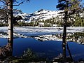
Ralston Peak is a mountain in the Sierra Nevada mountain range to the west of Lake Tahoe within the Desolation Wilderness in El Dorado County, California. Ralston Peak is a very popular mountain to summit for the views of the wilderness area as it lies very near U.S. Route 50. The closest trailhead to the summit can be found in Camp Sacramento a few miles west of Echo Summit. Ralston Peak can also be accessed from the Pacific Crest Trail between Echo Lake and Lake Aloha. Starting at the nearest trailhead (Echo Lake), this route is significantly longer than the trail from Camp Sacramento. But the altitude gain on this route is much less, and the trail is much less steep.

View of Lake Aloha from Ralston Peak Toward Lake Aloha from Ralston Peak summit.jpg
View of Lake Aloha from Ralston Peak

Related Research Articles

Sierra Nevada Mountain range in the Western United States

The Sierra Nevada is a mountain range in the Western United States, between the Central Valley of California and the Great Basin. The vast majority of the range lies in the state of California, although the Carson Range spur lies primarily in Nevada. The Sierra Nevada is part of the American Cordillera, an almost continuous chain of mountain ranges that forms the western "backbone" of the Americas.

El Dorado County, California County in California, United States

El Dorado County, officially the County of El Dorado, is a county in the U.S. state of California. As of the 2010 census, the population was 181,058. The county seat is Placerville.

Desolation Wilderness Protected wilderness area in California, United States

The Desolation Wilderness is a 63,960-acre (258.8 km2) federally protected wilderness area in the Eldorado National Forest and Lake Tahoe Basin Management Unit, in El Dorado County, California. The crest of the Sierra Nevada runs through it, just west of Lake Tahoe.

Trinity Alps Mountain range in Siskiyou and Trinity Counties

The Trinity Alps are a mountain range in Trinity County and Siskiyou County in Northern California. They are a subrange of the Klamath Mountains located to the north of Weaverville.

Granite Chief Wilderness Protected wilderness area in California, United States

The Granite Chief Wilderness is a 19,048 acre (77 km2) federally designated wilderness area of the Tahoe National Forest. Created by the California Wilderness Act of 1984, it is located in the Sierra Nevada mountains west of Lake Tahoe in the U.S. state of California. It is managed by the U.S. Forest Service Tahoe National Forest. Elevations range from 4,800 feet (1,500 m) to 9,019 feet (2,749 m) at the summit of Granite Chief.

Slide Mountain (Ulster County, New York) Highest peak of New Yorks Catskill Mountains

Slide Mountain is the highest peak in the Catskill Mountains of the U.S. state of New York. It is located in the town of Shandaken in Ulster County. While the 4,180-foot (1,270 m) contour line on topographic maps is generally accepted as its height, the exact elevation of the summit has never been officially determined by the U.S. Coast and Geodetic Survey, and many informal surveys suggest the mountain may actually top 4,200 feet above sea level.

Pyramid Peak (California)

Pyramid Peak is a mountain in the California's Sierra Nevada in the Crystal Range to the west of Lake Tahoe. It is the highest point in the Desolation Wilderness. With an elevation gain of almost 4,100 feet (1,250 m), the Rocky Canyon route is the mountain's most popular approach although it is very arduous. To the east, at the base of the peak, lies Pyramid Lake.

Mount Williamson

Mount Williamson, at 14,379 feet (4,383 m), is the second highest mountain in both the Sierra Nevada range and the state of California. It is the sixth highest peak in the contiguous United States.

Fallen Leaf Lake

Fallen Leaf Lake is a mountain lake located in El Dorado County, California, near the California–Nevada state border, about one mile south west of the much larger Lake Tahoe. It is approximately aligned north-to-south and oval in shape, measuring approximately 2.9 miles (4.6 km) on the long axis and 0.9 miles (1.4 km) on the short axis. The lake was created by at least two glaciers that traveled northward down the Glen Alpine Valley. If the glacier had continued instead of stopping, Fallen Leaf Lake would be a bay of Lake Tahoe, similar to nearby Emerald Bay. A terminal moraine is visible at the north end of the lake on the northeast edge.

U.S. Route 50 (US 50) is a transcontinental United States Numbered Highway, stretching from West Sacramento, California, in the west to Ocean City, Maryland, in the east. The California portion of US 50 runs east from Interstate 80 (I-80) in West Sacramento to the Nevada state line in South Lake Tahoe. A portion in Sacramento also has the unsigned designation of Interstate 305. The western half of the highway in California is a four-or-more-lane divided highway, mostly built to freeway standards, and known as the El Dorado Freeway outside of downtown Sacramento. US 50 continues as an undivided highway with one eastbound lane and two westbound lanes until the route reaches the canyon of the South Fork American River at Riverton. The remainder of the highway, which climbs along and out of the canyon, then over the Sierra Nevada at Echo Summit and into the Lake Tahoe Basin, is primarily a two-lane road.

Lake Aloha

Lake Aloha is a large shallow backcountry reservoir located at an elevation of 8,116 feet in the Sierra Nevada Range, west of Lake Tahoe in El Dorado County, in eastern California.

Talking Mountain

Talking Mountain in El Dorado County, California is a peak in the Sierra Nevada located on the high ridge that extends eastward from the summit of Ralston Peak in the Eldorado National Forest. It is south of Lake Tahoe, south of Echo Lake and marks the border of the Desolation Wilderness. South of the summit, U.S. Route 50 follows the South Fork of the American River.

Mount Tallac

Mount Tallac is a mountain peak southwest of Lake Tahoe, in El Dorado County, California. The peak lies within the Desolation Wilderness in the Eldorado National Forest. It is quite visible from State Routes 89 and 28, and U.S. Route 50. A "cross of snow" is clearly visible on the mountain's face during the winter, spring, and early summer months.

South Warner Wilderness Protected wilderness area in California, United States

The South Warner Wilderness is a federally designated wilderness area 12 miles (19 km) east of Alturas, California, United States. It encompasses more than 70,000 acres (283 km2) of the Warner Mountains. It is within the Modoc National Forest and managed by the US Forest Service. Elevations range from 5,000 feet (1,500 m) to 9,895 feet at Eagle Peak.

Dinkey Lakes Wilderness Protected wilderness area in California, United States

The Dinkey Lakes Wilderness is a federally designated wilderness area located 45 miles (72 km) northeast of Fresno, in the state of California, United States. It comprises 30,000 acres (12,141 ha) within the Sierra National Forest and was added to the National Wilderness Preservation System by the California Wilderness Act of 1984.

Yolla Bolly–Middle Eel Wilderness Protected wilderness area in California, United States

The Yolla Bolly–Middle Eel Wilderness is a federally designated wilderness area in the Yolla Bolly Range of the southern Klamath Mountains and the Inner Northern California Coast Ranges, in Northern California.

Dardanelles and Freel Roadless Areas

The Dardanelles and Freel Roadless Areas are located 7 miles (11 km) and 3 miles (4.8 km), respectively, south of Lake Tahoe, California, and both are managed by the Lake Tahoe Basin Management Unit of the US Forest Service.These areas are contiguous, separated only by the corridor of highway 89. The historic Hawley Grade, an immigrant wagon road, now a hiking trail, is within the Dardanelles Roadless Area, as well as the watershed of Lake Tahoe's largest inflow, the Upper Truckee River.

Echo Summit Mountain pass

Echo Summit is a mountain pass over the Sierra Nevada in the western United States, located in eastern El Dorado County, California. At 7,377 ft (2,249 m) above sea level, it is the highest point on U.S. Route 50 in California, which traverses it at postmile 66.48 between Twin Bridges and Meyers, south of Lake Tahoe.

California Alpine Club

The California Alpine Club (CAC) is an all-volunteer, outdoors-oriented social group centered in the San Francisco Bay and Sacramento areas that organizes hiking, skiing, member dinners, and wilderness trips. Club members also manage the California Alpine Club Foundation, which gives grants to California-based wilderness preservation, conservation, outdoor recreation, and education projects.

Tahoe–Yosemite Trail

The Tahoe–Yosemite Trail (TYT) is a long-distance trail in the Sierra Nevada mountain range of California. The trail courses 186 miles (299 km) from Meeks Bay at Lake Tahoe to Tuolumne Meadows in Yosemite National Park. The trail is a foot and equestrian path that passes through the Desolation, Mokelumne, Carson-Iceberg, Emigrant, and Yosemite Wilderness Areas and the Meiss Country (Dardanelles) Roadless Area.

References

  1. 1 2 "Ralston Peak, California". Peakbagger.com. Retrieved 2009-08-14.
  2. 1 2 "Tahoe OGUL Peaks List" . Retrieved 2021-11-07.
  3. "Ralston Peak". Geographic Names Information System . United States Geological Survey . Retrieved 2009-08-13.