
Chamarajanagar or Chamarajanagara is the southernmost district in the state of Karnataka, India. It was carved out of the original larger Mysore District in 1998. Chamarajanagar town is the headquarters of this district.

Soliga, also spelled Solega, Sholaga and Shōlaga, is an ethnic group of India. Its members inhabit the mountain ranges mostly in the Chamarajanagar district of southern Karnataka and Erode district of Tamil Nadu. Many are concentrated in the Biligiriranga Hills and associated ranges, mainly in the talukas Yelandur, Kollegal and Chamarajanagar of Karnataka. The Soliga speak Sholaga, which belongs to the Dravidian family. Under Indian law, they are recognized as a scheduled tribe, they have a population of around 40,000.
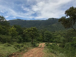
The Biligirirangana Hills or Biligirirangan Hills is a hill range situated in south-western Karnataka, at its border with Tamil Nadu in South India. The area is called Biligiri Ranganatha Swamy Temple Wildlife Sanctuary or simply BRT Wildlife Sanctuary. It is a protected reserve under the Wildlife Protection Act of 1972. Being close to the Eastern Ghats as well as the Western Ghats, the sanctuary has floral and faunal associations with both regions. The site was declared a tiger reserve in January 2011 by the Karnataka government, a few months after approval from India's National Tiger Conservation Authority.
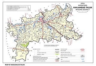
Nanjangud, officially known as Nanjanagudu, is a town in the Mysuru district of Indian state of Karnataka. Nanjangud lies on the banks of the river Kapila, 23 km from the city of Mysore. Nanjangud is famous for the Srikanteshwara Temple located here. Nanjangud is also called Dakshina Kashi. This town is also famous for a type of banana grown in the region called the Nanjanagoodu rasabale. Nanjangud's local administrative unit was designated as a Municipal Committee in 2015 by including Devirammanahalli and Kallahalli village.
Yelandur is a taluk and town in Chamarajanagar district in southern Karnataka, India. It has historic and cultural importance in this region. Along with three other taluks, it was officially included into Chamarajanagar district when the district was notified upon bifurcation of Mysore district in 1997.
Mulabagilu is a town and taluk headquarters of Mulabagilu taluk in the Kolar district in the state of Karnataka, India. It lies just off the National Highway 75 as the easternmost town of the state and a hill landmark.

Male Mahadeshwara Betta is a pilgrim town located in the Hanur taluk of Chamarajanagar district of southern Karnataka. It is situated at about 150 km from Mysuru and about 210 km from Bengaluru. The ancient and sacred temple of Sri Male Mahadeshwara is a pilgrim centre where Mahadeshwara lived, practiced medicine as Sidda, taught ahimsa to people in and around the seven hills. It draws lakhs of pilgrims from the states of Karnataka and Tamil Nadu. The area of the present temple surroundings is 155.57 acres (0.6296 km2). In addition, the temple has lands at Talabetta, Haleyuru and Indiganatha villages. Amidst dense forest, the temple attracts not only the pilgrims but also nature lovers. The height of the hill is about 3000 feet above sea level.

Kollegal is one of the major taluks in the Chamarajanagara District of Karnataka State in the south of India. It is also the largest taluk in Karnataka, Kollegal is well known for its silk industry which attracts traders from all over the state.

Basavanagudi is a residential and commercial locality in the Indian city of Bangalore. It is located in South Bangalore, along the borders of Jayanagar. The name "Basavanagudi" refers to the Bull Temple, which contains a monolith statue of the Nandi Bull. The word Basava in Kannada means bull, and gudi means temple. Basavanagudi is one of the oldest and poshest areas of Bangalore. 4.6 km far from Bangalore City Railway Station and BMTC, and 38.7 km to Kempegowda International airport. The main commercial street of Basavanagudi is DVG Road, which is home to numerous retail businesses - several of them dating back to the 1920s and 1930s. Towards the middle of DVG Road is Gandhi Bazaar, known for its markets which sell fresh flowers, fruits, and vegetables. The neighbourhood includes several historic restaurants, notably Vidyarthi Bhavan, a vegetarian restaurant which was opened in 1943.

Hanur is a town in Chamrajnagar district of Karnataka State, India.

Chamarajanagar or Chamarajanagara is a town in the southern part of Karnataka, India. Named after Chamaraja Wodeyar IX, the erstwhile king of Mysore, previously known as 'Arikottara'. Chamarajanagara is the headquarters of Chamarajanagar district. It is located on the interstate highway linking the neighboring states of Tamil Nadu and Kerala.

Melukote in Pandavapura taluk of Mandya district, Karnataka, in southern India, is one of the sacred places in Karnataka.It is built on rocky hills, known as Yadugiri, Yaadavagiri and Yadushailadeepa, overlooking the Cauvery valley. Melukote is about 51 km from Mysore and 133 km (83 mi) from Bangalore.
Huvina Hadagali is a town in Vijayanagara district.

Kumara Swamy Devasthana, also known as Sri Kumaraswaami Temple, is a Hindu temple located in Hanumanthanagar, in the city of Bangalore, Karnataka, southern India. It is dedicated to the god Kartikeya, also known as Subrahmanya, Kumara Swamy, or Murugan.

Vaikhanasa or Vaikhanasagama is a tradition of Hinduism that primarily worships Vishnu as the Supreme God. The tradition draws its name from the philosophy propounded by its founder, Sage Vikhanasa.
Pebbair is now a Municipal corporation and a Municipal corporation in Wanaparthy district in the state of Telangana, India. The Pebbair Municipal corporation extends from Pampuram village in the North to Yaparla village in the south..
Neraluru is a village in Anekal taluk, Bangalore urban district, India. It is around 28 kilometers from Bangalore and 10 kilometers from Hosur, Tamil Nadu. The nearest mofussil towns are Attibele and Chandapura, both of which are within a 5 kilometer radius of Neralur. Electronics City, one of India's largest Information Technology parks, is around 10 kilometres from the village. A few of the villages which share its boundaries with Neralur are - Guddahatti, Balagaranahalli, Lakshmisagara, Old Chandapura, Thirumagondanahalli, Bandapura, Yadavanahalli and Bendaganahalli. Kannada is the most widely spoken language in the village. With the advent of migrant laborers, and as a consequence of private townships springing up in unbridled abundance, people from all over the country can be found in varying proportions, which has made the language demographics getting diversified, thereby showcasing the multi cultural, multi ethnic splendour of our motherland.
Ajjipura is a village in the southern state of Karnataka, India. It is located in the Hanur taluk of Chamarajanagar district. It is surrounded by Hanur, Ramapura, Cowdalli and Male Mahadeshwra Hills. Ajjipura is closely surrounded by Kurubaradoddi, Suleripalya (Kanchalli), Basappanadoddi and K Gundapura. Dommanagadde, G R Nagara, Naganna Nagara, Vaddaradoddi, Ambikapura are sub-villages.
Ponnachi is a village in the southern state of Karnataka, India. It is located in the Hanur taluk of Chamarajanagar district. Which recently named as the First 5G Village in India.It present in eastern ghats, It is the last end village demarcates Karnataka and Tamil Nadu by river cauvery, Name ponnachi suggest that Ponna means gold, Aachi which is used to call for villages Tamil Nadu administration. It is the mining area and present mainly composed of igneous and metamorphic rocks of Pre-Cambrian age either exposed at the surface or covered with a thin mantle of residual and transported soils. The rock formation in the district falls into two groups, Charnockite series and granite genesis and gneissic granite. The village has a nice cinematic view with surrounded by mesa type of mountains.
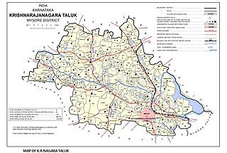
Saligrama is a new sub-district of Mysore district, situated on the northern bank of the river Cauvery [Kaveri]. This place is esteemed as sacred by the Shri Vaishnavas on account of its having been the residence of Sri Ramanujacharya. It is the headquarters of Saligrama Taluk. It was established as a new taluk carving out of K.R.Nagar taluk with effect from 31.12.2020 and become ninth taluk of Mysore district of Karnataka, India.

