Ratnagiri railway division

Last updated

Ratnagiri railway division is one of the two railway divisions under Konkan Railway of Indian Railways. This railway division was formed on 26 January 1998 and its headquarter is located at Ratnagiri in the state of Maharashtra of India.

Ratnagiri railway division is another railway division under Konkan Railway headquartered at Mumbai. The Ratnagiri railway region extends over 480 kilometres (300 mi) from Roha to Sawantwadi in Maharashtra. Ratnagiri railway region is headed by a Regional Railway Manager. [1] [2] [3] [4]

List of railway stations and towns

The list includes the stations under the Ratnagiri railway division and their station category.

Category of stationNo. of stationsNames of stations
A-10
A7
B- Ratnagiri, Kankavali, Sindhudurg, Sawantwadi Road, Roha, Chiplun,
C
Suburban station
--
D--
E--
F
Halt station
--
Total--

Related Research Articles

Maharashtra State in Western India

Maharashtra is a state in the western peninsular region of India occupying a substantial portion of the Deccan Plateau. Maharashtra is the second-most populous state in India as well as the second-most populous country subdivision. It was formed on 1 May 1960 by splitting the bilingual Bombay State, which had existed since 1956, into majority Marathi-speaking Maharashtra and Gujarati-speaking Gujarat. The state capital is Mumbai, the most populous urban area in India. The Godavari and the Krishna are the two major rivers in the state. Marathi is the most widely spoken language and is also the official language of the state.

Konkan Railway Railway in Maharashtra, India

The Konkan Railway is a railway operated by the Konkan Railway Corporation, with its headquarters at CBD Belapur in Navi Mumbai, Maharashtra, India. The first passenger train ran on Konkan railway tracks on 20 March 1993, between Udupi and Mangalore. During its initial years of operation in the mountainous Konkan region, a number of accidents prompted Konkan Railway to implement new technology. Anti-collision devices, the Sky Bus and roll-on/roll-off are several of the railway's innovations. The 756.25 km (469.91 mi) long railway line connects the states of Maharashtra, Goa and Karnataka. The first train on the completed track was sent off on 26 January 1998.

Ratnagiri City in Maharashtra, India

Ratnagiri (IAST:Ratnāgirī) is a port city on the Arabian Sea coast in Ratnagiri District in the southwestern part of Maharashtra, India. The district is a part of Konkan division of Maharashtra. Ratnagiri is often mentioned in the TV Show Taarak Mehta Ka Ooltah Chashmah, ss the Bhide is from there

Ganpatipule City in Maharashtra, India

Ganpatipule (Gaṇpatīpuḷē) is a small town located 25 kms north of the city of Ratnagiri in Ratnagiri district on the Konkan coast of Maharashtra, in the sub-continent of India. The town of Chiplun is located to its north.

Konkan Railway Corporation Unit of Indian Railways

Konkan Railway Corporation Limited (KRCL) is a Union Government Company headquartered at CBD Belapur in Navi Mumbai that operates Konkan Railway and also undertakes other railway-related projects. The railway (railroad) route of KRCL covers the coastal districts of Maharashtra, Goa and Karnataka states of India (Bharat). The company started its full operations of trains on 26 January 1998.The first passenger train which ran on Konkan railway tracks on 20 March 1993 between Udupi and Mangalore. Konkan Railway Corporation is at the forefront of research and development of new technologies and concepts for Indian railways. During its initial years of operations in the mountainous Konkan region, a spate of accidents prompted Konkan Railway to investigate new technologies. The anti-collision devices, the Sky Bus and RORO are a few of Konkan Railyway's innovations.

Khed, Ratnagiri town in Maharashtra, India

Khed is a town with a municipal council in the Ratnagiri district of the state of Maharashtra, India. Situated on the Mumbai - Goa Highway, NH 66, it is surrounded by a number of villages.

Sawantwadi taluka City in Maharashtra, India

Sawantwadi is a taluka in the Sindhudurg district in the Indian state of Maharashtra. The taluka headquarters is Sawantwadi which has a municipal council, which is a local civic body. Sawantwadi was formerly the capital of the Kingdom of Sawantwadi, ruled by the Sawant Bhonsle royal clan of the Marathas.

Konkani Muslims are an ethnoreligious subgroup of the Konkani people primarily living in the Konkan region of western India, who practise Islam. Indigenous Muslims from the districts of Sindhudurg, Ratnagiri, Raigad, Mumbai (Bombay) city and suburb, and Thane are generally regarded as Konkani Muslims. Karwari Konkani Muslims of Bhatkal, situated at the southern border of Konkan in Uttara Kannada district of Karnataka are known as Nawayaths

Devgad taluka

Devgad is a taluka in Sindhudurg district of Maharashtra India consisting of 98 villages. It is located on the Arabian Sea in the coastal Konkan region of Maharashtra, south of Mumbai. Devgad is known globally for its exports of locally grown Alphonso mangoes.

Economy of Maharashtra Economy of the state of India

The economy of Maharashtra is the largest in India. It is one of the most urbanised of Indian States.

Ratnagiri Airport

Ratnagiri Airport is a public airport located in Mirjole, Ratnagiri district, in the Konkan division of the state of Maharashtra, India.

Roha railway station

Roha railway station is the terminus railway station on the Panvel–Roha route of Central Railway in India. It is 143.61 km from Chhatrapati Shivaji Terminus via Diva Junction. It belongs to the Mumbai division of Central Railway.

Maharashtra is a state in the western region of India. It is the second most populous state and third largest state by area in India. Maharashtra is bordered by the Arabian Sea to the west, Gujarat and the Union territory of Dadra and Nagar Haveli to the northwest, Madhya Pradesh to the north and northeast, Chhattisgarh to the east, Karnataka to the south, Telangana to the southeast and Goa to the southwest. The state covers an area of 307,731 km2 (118,816 sq mi) or 9.84% of the total geographical area of India.

Ratnagiri railway station

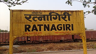
Ratnagiri railway station (RN) is a train station that serves the city of Ratnagiri in the Indian state of Maharashtra. It is the one of the main railway stations of the Konkan Railway. The station has modern facilities like elevator and escalator. The station offers free Wi-Fi. All Konkan Railway trains halt at Ratnagiri. It is 7 km away from the city. It falls under the Ratnagiri railway division.

Kolad railway station

Kolad railway station is the first railway station on the Konkan Railway. It is at a distance of 12.916 km down from Roha railway station which comes under Konkan Railway. The succeeding station is Indapur railway station, a halt station.

Indapur railway station

Indapur railway station is a railway station on Konkan Railway line of Indian Railways. It is located near the town of Indapur in the Raigad district of Maharashtra. It is at a distance of 23.86 km (14.8 mi) down from northern end of Konkan Railways. The previous station on the line is Kolad railway station and the succeeding station is Mangaon railway station.

Ukshi railway station

Ukshi railway station is a station on the Konkan Railway in India.

Nivasar railway station

Nivasar railway station is a station on Konkan Railway. It is at a distance of 196.432 kilometres (122.1 mi) down from origin. The preceding station on the line is Ratnagiri railway station and the next station is Adavali railway station.

Karwar railway division is one of the two railway divisions under Konkan Railway of Indian Railways. This railway division was formed on 26 January 1998 and its headquarter is located at Karwar in the state of Karnataka of India.

National Highway 166 (India)

National Highway 166 is a National Highway in India. It runs from Ratnagiri to Solapur in Maharashtra and is a branch of National Highway 66. This is a main link connecting Konkan region to Vidarbha region in Maharashtra.

References

  1. "Organisation Chart - Commercial Department" (PDF). Archived from the original (PDF) on 6 February 2016. Retrieved 29 January 2016.
  2. "Departmental Chart - Operating" (PDF). Archived from the original (PDF) on 6 February 2016. Retrieved 29 January 2016.
  3. "DEPARTMENTAL CHART OF ENGINEERING DEPARTMENT" (PDF). Archived from the original (PDF) on 6 February 2016. Retrieved 29 January 2016.
  4. "MECHANICAL DEPARTMENT" (PDF). Archived from the original (PDF) on 6 February 2016. Retrieved 29 January 2016.

km
BSicon CONTg.svg
to Panvel (CSTM)
BSicon BHF.svg
0
Roha
(RN)
BSicon HST.svg
12.916
Kolad
BSicon HST.svg
24
Indapur
BSicon HST.svg
30.300
Mangaon
BSicon HST.svg
41
Goregaon Road
BSicon HST.svg
46.885
Veer
BSicon TUNNEL1.svg
Tunnel 1
BSicon bWBRUCKE1.svg
Dasgaon Bridge over Savitri River
BSicon HST.svg
55
Sape Wamane
BSicon TUNNEL1.svg
Tunnel 2
BSicon HST.svg
62.785
Karanjadi
BSicon TUNNEL1.svg
Tunnel 3
BSicon TUNNEL1.svg
Tunnel 4
BSicon TUNNEL1.svg
Tunnel 5
BSicon HST.svg
71
Vinhere
BSicon TUNNEL1.svg
Natuwadi Tunnel/ Tunnel 6
4.389 km
2.727 mi
BSicon HST.svg
80.585
Diwankhavati
BSicon TUNNEL1.svg
Tunnel 7
BSicon HST.svg
Kalambani
BSicon bWBRUCKE1.svg
Bridge over Jagbudi River
BSicon HST.svg
98.285
Khed
BSicon TUNNEL1.svg
Tunnel 8
BSicon TUNNEL1.svg
Tunnel 9
BSicon TUNNEL1.svg
Tunnel 10
BSicon TUNNEL1.svg
Tunnel 11
BSicon TUNNEL1.svg
Tunnel 12
BSicon HST.svg
111.690
Anjani
BSicon TUNNEL1.svg
Tunnel 13
BSicon TUNNEL1.svg
Tunnel 14
BSicon TUNNEL1.svg
Tunnel 15
BSicon HST.svg
127.877
Chiplun
BSicon bWBRUCKE1.svg
Bridge over Vashishti River
BSicon TUNNEL1.svg
Chiplun Tunnel/ Tunnel 16
2.100 km
1.305 mi
BSicon HST.svg
137.646
Kamathe
BSicon TUNNEL1.svg
Savarde Tunnel/ Tunnel 17
3.429 km
2.131 mi
BSicon HST.svg
146.302
Sawarda
BSicon TUNNEL1.svg
Tunnel 18
BSicon hSTRae.svg
Viaduct
BSicon TUNNEL1.svg
Tunnel 19
BSicon bWBRUCKE1.svg
Bridge over Jaigad River
BSicon HST.svg
156.414
Aravali Road
BSicon TUNNEL1.svg
Tunnel 20
BSicon TUNNEL1.svg
Aravali Tunnel/ Tunnel 21
2.161 km
1.343 mi
BSicon TUNNEL1.svg
Tunnel 22
BSicon TUNNEL1.svg
Tunnel 23
BSicon HST.svg
170.285
Sangameshwar Road
BSicon TUNNEL1.svg
Tunnel 24
BSicon TUNNEL1.svg
Tunnel 25
BSicon TUNNEL1.svg
Tunnel 26
BSicon HST.svg
178.200
Digni
BSicon bWBRUCKE1.svg
Shastri Bridge over Bav River
BSicon TUNNEL1.svg
Parchuri Tunnel/ Tunnel 27
2.552 km
1.586 mi
BSicon TUNNEL1.svg
Tunnel 28
BSicon TUNNEL1.svg
Ukshi Tunnel/ Tunnel 29
0.104 km
0.065 mi
BSicon HST.svg
183.962
Ukshi
BSicon TUNNEL1.svg
Tunnel 30
BSicon TUNNEL1.svg
Tunnel 31
BSicon TUNNEL1.svg
Tunnel 32
BSicon bWBRUCKE1.svg
Bridge at Ukshi Falls
BSicon TUNNEL1.svg
Tunnel 33
BSicon TUNNEL1.svg
Tunnel 34
BSicon TUNNEL1.svg
Karbude Tunnel/ Tunnel 35
6.506 km
4.043 mi
BSicon HST.svg
196.482
Bhoke
BSicon hSTRae.svg
viaduct
BSicon TUNNEL1.svg
Tunnel 36
BSicon TUNNEL1.svg
Tunnel 37
BSicon BHF.svg
203.600
Ratnagiri
BSicon TUNNEL1.svg
Tunnel 38
BSicon hSTRae.svg
Pomendi viaduct
BSicon TUNNEL1.svg
Tunnel 39
BSicon hbKRZWae.svg
Panval Nadi/ Panval Setu Viaduct over Panval River
BSicon TUNNEL1.svg
Tike Tunnel/ Tunnel 40
4.077 km
2.533 mi
BSicon TUNNEL1.svg
Tunnel 41
BSicon BST.svg
218.993
Nivasar
BSicon TUNNEL1.svg
Tunnel 42
BSicon TUNNEL1.svg
Tunnel 43
BSicon TUNNEL1.svg
Tunnel 44
BSicon TUNNEL1.svg
Tunnel 45
BSicon TUNNEL1.svg
Tunnel 46
BSicon bWBRUCKE1.svg
Bridge over Kajali River
BSicon TUNNEL1.svg
Tunnel 47
BSicon HST.svg
235.280
Adavali
BSicon TUNNEL1.svg
Tunnel 48
BSicon TUNNEL1.svg
Tunnel 49
BSicon TUNNEL1.svg
Berdewadi Tunnel/ Tunnel 50
4.00 km
2.49 mi
BSicon HST.svg
Veravali
BSicon TUNNEL1.svg
Tunnel 51
BSicon bWBRUCKE1.svg
Bridge over Muchkundi River
BSicon TUNNEL1.svg
Tunnel 52
BSicon TUNNEL1.svg
249.713 - 250.282
Tunnel 53
0.569 km
0.354 mi
BSicon HST.svg
250.718
Vilavade
BSicon TUNNEL1.svg
Tunnel 54
BSicon TUNNEL1.svg
Tunnel 55
BSicon TUNNEL1.svg
Tunnel 56
BSicon TUNNEL1.svg
Tunnel 57
BSicon TUNNEL1.svg
Tunnel 58
BSicon TUNNEL1.svg
Tunnel 59
BSicon TUNNEL1.svg
Tunnel 60
BSicon HST.svg
Saundal
BSicon bWBRUCKE1.svg
Bridge over Arjuna River
BSicon TUNNEL1.svg
Tunnel 61
BSicon TUNNEL1.svg
Tunnel 62
BSicon HST.svg
267.349
Rajapur Road
BSicon TUNNEL1.svg
Tunnel 63
BSicon TUNNEL1.svg
Tunnel 64
BSicon TUNNEL1.svg
Tunnel 65
BSicon bWBRUCKE1.svg
Bridge over Vaghotan River
BSicon HST.svg
Chinchawali
BSicon TUNNEL1.svg
Tunnel 66
BSicon TUNNEL1.svg
Tunnel 67
BSicon bWBRUCKE1.svg
Bridge over River
BSicon HST.svg
283.943
Vaibhavwadi Road
BSicon bWBRUCKE1.svg
Bridge over Devgad tributary
BSicon bWBRUCKE1.svg
Bridge over Devgad River
BSicon HST.svg
299.552
Nandgaon Road
BSicon bWBRUCKE1.svg
Bridge over Janavali River
BSicon HST.svg
314
Kankavali
BSicon bWBRUCKE1.svg
Bridge over Gad River
BSicon bWBRUCKE1.svg
Bridge over Kasal River
BSicon HST.svg
332.560
Sindhudurg
BSicon bWBRUCKE1.svg
Bridge over Karli River
BSicon BHF.svg
343.037
Kudal
BSicon HST.svg
353
Zarap
BSicon HST.svg
363.880
Sawantwadi Road
BSicon HST.svg
371
Madure
BSicon STR+GRZq.svg
Maharashtra
Goa
border
RN
KAWR
limits
BSicon bWBRUCKE1.svg
Bridge over Terekhol River
BSicon TUNNEL1.svg
Pernem Tunnel/ Tunnel 69
1 km
1 mi
BSicon HST.svg
385.520
Pernem
BSicon bWBRUCKE1.svg
Revora Bridge over Chapora River
BSicon BHF.svg
396.430
Thivim
BSicon bWBRUCKE1.svg
Bridge over Assonora River
BSicon bWBRUCKE1.svg
Bridge over Mandovi River (side branch)
BSicon bWBRUCKE1.svg
Bridge over Mandovi River (major distributary)
BSicon TUNNEL1.svg
411.866 - 412.410
Old Goa Tunnel/Tunnel 70
0.544 km
0.338 mi
BSicon HST.svg
411
Karmali
BSicon hbKRZWae.svg
Bridge over Zuari River
BSicon TUNNEL1.svg
Tunnel 71
BSicon BST.svg
429.8
Verna
BSicon CONTgq.svg
BSicon ABZg+r.svg
BSicon BST.svg
434.8
Majorda Junction
BSicon HST.svg
Suravali
BSicon BHF.svg
442.460
Madgaon Junction
BSicon ABZgl.svg
BSicon CONTfq.svg
BSicon TUNNEL1.svg
Tunnel 72
BSicon TUNNEL1.svg
Tunnel 73
BSicon BST.svg
458.635
Balli
BSicon TUNNEL1.svg
Tunnel 74
BSicon TUNNEL1.svg
Barcem Tunnel/ Tunnel 75
3.343 km
2.077 mi
BSicon TUNNEL1.svg
Tunnel 76
BSicon TUNNEL1.svg
Tunnel 77
BSicon HST.svg
475.240
Canacona
BSicon bWBRUCKE1.svg
Bridge over Talpona River
BSicon bWBRUCKE1.svg
Bridge over Galgibag River
BSicon TUNNEL1.svg
Loliem Tunnel/Tunnel 78
0.835 km
0.519 mi
BSicon HST.svg
482
Loliem
BSicon TUNNEL1.svg
Tunnel 79
BSicon STR+GRZq.svg
BSicon HST.svg
493.221
Asnoti
BSicon hbKRZWae.svg
Karwar Bridge over Kalinadi River
BSicon BHF.svg
501.021
Karwar
BSicon TUNNEL1.svg
Karwar Tunnel/ Tunnel 80
2.950 km
1.833 mi
BSicon TUNNEL1.svg
Tunnel 81
BSicon TUNNEL1.svg
Tunnel 82
BSicon HST.svg
514.636
Harwada
BSicon bWBRUCKE1.svg
Hattikeri Bridge over River
BSicon TUNNEL1.svg
Tunnel 83
BSicon HST.svg
529.001
Ankola
BSicon bWBRUCKE1.svg
Bridge over Gangavali River
BSicon HST.svg
536.941
Gokarna Road
BSicon TUNNEL1.svg
Tunnel 84
BSicon HST.svg
548.480
Mirjan
BSicon TUNNEL1.svg
Tunnel 85
BSicon bWBRUCKE1.svg
Bridge over Aghnashini River
BSicon HST.svg
556.032
Kumta
BSicon bWBRUCKE1.svg
Bridge over River
BSicon HST.svg
569.812
Honnavar
BSicon TUNNEL1.svg
Honnavar Tunnel/ Tunnel 87
BSicon TUNNEL1.svg
Honnavar Tunnel/ Tunnel 88
1.254 km
0.779 mi
BSicon bWBRUCKE1.svg
Bridge over Badagani River
BSicon bWBRUCKE1.svg
Bridge over Sharavati River
BSicon TUNNEL1.svg
Tunnel 89
BSicon BST.svg
587.608
Manki
BSicon HST.svg
596.005
Murdeshwar
BSicon HST.svg
603
Chitrapur
BSicon bWBRUCKE1.svg
Bridge over Venkatapur River
BSicon TUNNEL1.svg
Tunnel 90 ("Tunnel No 91" on Google Maps)
BSicon HST.svg
610.740
Bhatkal
BSicon HST.svg
618.6
Shiroor
BSicon TUNNEL1.svg
Tunnel 91 ("Tunnel No 92" on Google Maps)
BSicon HST.svg
625
Mookambika Road Byndoor
BSicon bWBRUCKE1.svg
Bridge over Byndoor River
BSicon HST.svg
632.352
Bijoor
BSicon bWBRUCKE1.svg
Bridge over Yadamavu River
BSicon bWBRUCKE1.svg
Bridge over Kolluru River
BSicon HST.svg
646.192
Senapura
BSicon bWBRUCKE1.svg
Bridge over Chakra River
BSicon bWBRUCKE1.svg
Bridge over Panchagagavali River (side branch)
BSicon bWBRUCKE1.svg
Bridge over Panchagagavali River (major distributary)
BSicon HST.svg
660.0
Kundapura
BSicon HST.svg
675.572
Barkur
BSicon bWBRUCKE1.svg
Bridge over Sita River
BSicon bWBRUCKE1.svg
Bridge over River am Uppoor/Heroor Damm
BSicon bWBRUCKE1.svg
Bridge over Suvarna River
BSicon BHF.svg
691.9
Udupi
BSicon bWBRUCKE1.svg
Bridge over Udyavara River
BSicon BST.svg
700
Innanje
BSicon HST.svg
708.320
Padubidri
BSicon ABZg+l.svg
Siding to coal power station (Udupi Power Corp. Ltd.)
BSicon HST.svg
715
Nandikoor
BSicon bWBRUCKE1.svg
Bridge over Shambavi River
BSicon HST.svg
724.8
Mulki
BSicon bWBRUCKE1.svg
Bridge over Nandini River
BSicon HST.svg
733.825
Surathkal
BSicon BHF.svg
738.440
Thokur
(KAWR)
BSicon ABZgr+r.svg
Siding to New Mangalore Port
BSicon dWASSERq.svg
BSicon WBRUCKE2.svg
BSicon dWASSERq.svg
BSicon ABZgl.svg
BSicon CONTfq.svg
to Hassan Junction (MYS)
BSicon CONTf.svg
km