Ready, Kentucky

Last updated

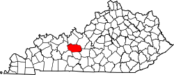
Ready is an unincorporated community in Grayson County, Kentucky. [1]

Grayson County, Kentucky County in the United States

Grayson County is a county located in the U.S. state of Kentucky. As of the 2010 census, the population was 25,746. Its county seat is Leitchfield. The county was formed in 1810 and named for William Grayson (1740-1790), a Revolutionary War colonel and a prominent Virginia political figure. Grayson County was formerly a prohibition or dry county, but Leitchfield allowed limited alcohol sales in restaurants in 2010 and voted "wet" in 2016.

History

A post office called Ready was established in 1884, and remained in operation until 1974. [2] The origin of the name "Ready" is obscure. [3]

A post office is a public department that provides a customer service to the public and handles their mail needs. Post offices offer mail-related services such as acceptance of letters and parcels; provision of post office boxes; and sale of postage stamps, packaging, and stationery. In addition, many post offices offer additional services: providing and accepting government forms, processing government services and fees, and banking services. The chief administrator of a post office is called a postmaster.

Related Research Articles

Sleeper, Missouri unincorporated community in Laclede County, Missouri, United States

Sleeper is an unincorporated community in Laclede County, Missouri, United States. It is located approximately one mile north of Interstate 44 on Missouri Supplemental Route F, or about five miles northeast of Lebanon. Several homes and a fire station are located here.

Roggen, Colorado Unincorporated community in Colorado, United States

Roggen is an unincorporated community and a U.S. Post Office in Weld County, Colorado, United States. The Roggen Post Office has the ZIP Code 80652.

Atchison is a former settlement in Contra Costa County, California. It was located 1 mile (1.6 km) southeast of Richmond. Its site has now been incorporated by Richmond. The town was most noted as the local headquarters of the Atchison, Topeka, and Santa Fe Railroad, after which it was named.

Stewart is a former settlement in Inyo County, California. It was located near the site of the current settlement of Deep Springs.

Beefhide, Kentucky Unincorporated community in Kentucky, United States

Beefhide is an unincorporated community spanning across a county line between Letcher County and Pike County, Kentucky, United States.

Mousie, Kentucky Unincorporated community in Kentucky, United States

Mousie is an unincorporated community within Knott County, Kentucky, United States.

Rest is an unincorporated community in Wilson County, Kansas, United States.

Duty is an unincorporated community in Dickenson County, Virginia, in the United States.

Barrier is an unincorporated community in Wayne County, in the U.S. state of Kentucky. The community is located on Kentucky Route 92.

Beefhide Creek is a stream in Letcher and Pike Counties of the U.S. state of Kentucky.

Cash is an unincorporated area in Hart County, Kentucky.

Dusty is an unincorporated community in Socorro County, New Mexico.

Jump Station is an unincorporated community in Floyd County, Kentucky.

Overall is an unincorporated community in Rutherford County, Tennessee.

Pointer is an unincorporated community in Pulaski County, Kentucky.

Pomp is an unincorporated community in Morgan County, Kentucky.

Dandy is an unincorporated community in York County, Virginia.

Drill is an unincorporated community in Buchanan and Russell counties, Virginia, United States.

Million is an unincorporated community in Madison County, Kentucky.

Pluck is an unincorporated community in Polk County, Texas, United States.

References

  1. U.S. Geological Survey Geographic Names Information System: Ready, Kentucky
  2. "Post Offices". Jim Forte Postal History. Retrieved 5 January 2017.
  3. Moyer, Armond; Moyer, Winifred (1958). The origins of unusual place-names. Keystone Pub. Associates. pp. 141–143.

Coordinates: 37°22′18″N86°28′17″W / 37.37167°N 86.47139°W / 37.37167; -86.47139
Geographic coordinate system Coordinate system

A geographic coordinate system is a coordinate system that enables every location on Earth to be specified by a set of numbers, letters or symbols. The coordinates are often chosen such that one of the numbers represents a vertical position and two or three of the numbers represent a horizontal position; alternatively, a geographic position may be expressed in a combined three-dimensional Cartesian vector. A common choice of coordinates is latitude, longitude and elevation. To specify a location on a plane requires a map projection.