Anneta | |
---|---|
Coordinates: 37°22′15″N86°14′43″W / 37.37083°N 86.24528°W | |
Country | United States |
State | Kentucky |
County | Grayson |
Elevation | 771 ft (235 m) |
Time zone | UTC-6 (Central (CST)) |
• Summer (DST) | UTC-5 (CDT) |
ZIP codes | 42754 |
Area code(s) | 270 and 364 |
GNIS feature ID | 507402 [1] |
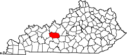
Anneta is an unincorporated community located in southern Grayson County, Kentucky, United States. [2]
Anneta is located about 8 miles (13 km) south-southeast of Leitchfield along Kentucky Route 259 (KY 259).
Students in the area attend Grayson County Schools, including Grayson County High School.
Grayson County is a county located in the U.S. state of Kentucky. As of the 2020 census, the population was 26,420. Its county seat is Leitchfield. The county was formed in 1810 and named for William Grayson (1740-1790), a Revolutionary War colonel and a prominent Virginia political figure. Grayson County was formerly a prohibition or dry county, but Leitchfield allowed limited alcohol sales in restaurants in 2010 and voted "wet" in 2016.
Brownsville is a home rule-class city in Edmonson County, Kentucky, in the United States. It is the county seat and is a certified Kentucky Trail Town. The population was 836 at the time of the 2010 census, down from 921 at the 2000 census. It is included in the Bowling Green metropolitan area. It is just outside Mammoth Cave National Park.
Leitchfield is the county seat of Grayson County, Kentucky, United States. Leitchfield is a home rule-class city with a population of 6,404 as of the 2020 census.
Nolin River Lake is a reservoir in Edmonson, Grayson, and Hart counties in Kentucky. It was impounded from the Nolin River by the United States Army Corps of Engineers in 1963. The Nolin River dam was authorized in 1938 as part of a flood control act. The lake varies from 2,890 acres (11.7 km2) in the winter to 5,795 acres (23.5 km2) in the summer.
Shrewsbury is a declining rural unincorporated community located within Grayson County, Kentucky, United States.
Elizabethtown Community and Technical College (ECTC) is a community college in Elizabethtown, Kentucky. It is one of 16 two-year, open-admissions colleges of the Kentucky Community and Technical College System (KCTCS).
Grayson County High School may refer to either of the following United States high schools:
The Rough River Lake is a Y-shaped reservoir located in Breckinridge, Hardin, and Grayson counties in Kentucky, about 70 miles southwest of Louisville. This lake was created by the building of a dam, begun in 1955 and completed in 1961, 89.3 miles above the connection between the Rough River and the Green River. The land and water, along with the wildlife, fisheries, and recreational activities, are all managed under the cooperation of the U.S. Army Corps of Engineers and the Commonwealth of Kentucky. A primary attraction is Rough River Dam State Resort Park.
Chester Otto Carrier was a U.S. Representative from Kentucky.
Grayson County High School is the only major high school located in Leitchfield, Kentucky, United States. The school is home to approximately 1300 students with a lightly fluctuating population throughout the year. Grayson County High School is home to several accomplished sports teams, including cheerleading, baseball, softball, football, soccer, volleyball, tennis, golf, track, cross country and basketball teams. The school is also home to successful extracurricular groups including the DECA and academic team.
Big Reedy is an unincorporated community in the northwest corner of Edmonson County, Kentucky, United States, near the boundaries of Grayson and Butler counties. It is approximately 25 miles (40 km) due north of Bowling Green.
Kentucky Route 259 is a 95.91-mile-long (154.35 km) state highway that traverses five counties in west-central Kentucky.
Sunfish is an unincorporated community located in the northwest corner of Edmonson County, Kentucky, United States, near the Grayson County line. It is approximately 25 miles (40 km) north-northeast of Bowling Green.
Grayson Springs is an unincorporated community in Grayson County, Kentucky, United States. Grayson Springs is located at the junction of Kentucky Routes 88 and 1214, 4.1 miles (6.6 km) east-southeast of Leitchfield.
Kentucky Route 54 is a 54.329-mile-long (87.434 km) state highway in the U.S. state of Kentucky.
Kentucky Route 187 (KY 187) is a north–south state highway that traverses Edmonson and Grayson counties in west-central Kentucky.
Kentucky Route 3155 (KY 3155), also known as the William Thomason Byway, or known locally as the Leitchfield Bypass, is a 4.697-mile-long (7.559 km) state route located entirely in central Grayson County in north-central Kentucky. Both of this road's termini are intersections with KY 259 on the north and south sides of Leitchfield as it is a partial beltway around the city.
Kentucky Route 226 is a 1.303-mile-long (2.097 km) rural, secondary state highway located entirely in Grayson County, Kentucky.
Grayson County Courthouse may refer to:
Kentucky Route 737 (KY 737) is a 9.5-mile-long (15.3 km) state highway in northwestern Grayson and southern Breckinridge counties in west central Kentucky. The route runs from KY 259 in northern Leitchfield to the same route southeast of McDaniels via Lilac and Fisher. The route crosses Rough River Lake at the Grayson—Breckinridge county line.