
Limestone is a type of carbonate sedimentary rock which is the main source of the material lime. It is composed mostly of the minerals calcite and aragonite, which are different crystal forms of CaCO3. Limestone forms when these minerals precipitate out of water containing dissolved calcium. This can take place through both biological and nonbiological processes, though biological processes, such as the accumulation of corals and shells in the sea, have likely been more important for the last 540 million years. Limestone often contains fossils which provide scientists with information on ancient environments and on the evolution of life.

Stromatolites or stromatoliths are layered sedimentary formations (microbialite) that are created mainly by photosynthetic microorganisms such as cyanobacteria, sulfate-reducing bacteria, and Pseudomonadota. These microorganisms produce adhesive compounds that cement sand and other rocky materials to form mineral "microbial mats". In turn, these mats build up layer by layer, growing gradually over time.

A reef is a ridge or shoal of rock, coral, or similar relatively stable material lying beneath the surface of a natural body of water. Many reefs result from natural, abiotic (non-living) processes such as deposition of sand or wave erosion planning down rock outcrops. However, reefs such as the coral reefs of tropical waters are formed by biotic (living) processes, dominated by corals and coralline algae. Artificial reefs, such as shipwrecks and other man-made underwater structures, may occur intentionally or as the result of an accident. These are sometimes designed to increase the physical complexity of featureless sand bottoms to attract a more diverse range of organisms. Reefs are often quite near to the surface, but not all definitions require this.

Tufa is a variety of limestone formed when carbonate minerals precipitate out of water in unheated rivers or lakes. Geothermally heated hot springs sometimes produce similar carbonate deposits, which are known as travertine or thermogene travertine. Tufa is sometimes referred to as meteogene travertine.
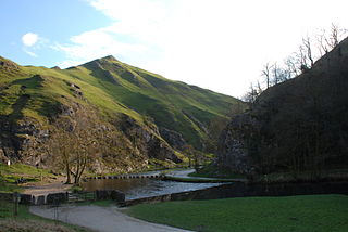
Dovedale is a valley in the Peak District of England. The land is owned by the National Trust and attracts a million visitors annually. The valley was cut by the River Dove and runs for just over 3 miles (5 km) between Milldale in the north and a wooded ravine, near Thorpe Cloud and Bunster Hill, in the south. In the wooded ravine, a set of stepping stones cross the river and there are two caves known as the Dove Holes.
Calcareous is an adjective meaning "mostly or partly composed of calcium carbonate", in other words, containing lime or being chalky. The term is used in a wide variety of scientific disciplines.

Parkhouse Hill is a small but distinctive hill in the Peak District National Park of the Hartington Middle Quarter civil parish, in the English county of Derbyshire. It lies on the north side of the River Dove, close to the border with Staffordshire.

Chrome Hill is a limestone reef knoll in Derbyshire, England, in the upper Dove valley beside the border with Staffordshire, within the civil parish of Hartington Middle Quarter. It is adjacent to Parkhouse Hill, another reef knoll. The walk over Chrome Hill and Parkhouse Hill is known as the Dragon's Back ridge.

Cracoe is a small village and civil parish in the former Craven District of North Yorkshire, England. It is situated near to Rylstone and about 6 miles south-west of Grassington. Cracoe has an estimated population of 160 residents, measured at 178 in the 2011 census. Cracoe is a village which is also situated near Rylstone beneath Barden Fell and the twin skyline landmarks of Rylstone Cross and Cracoe Pinnacle in the Yorkshire Dales.
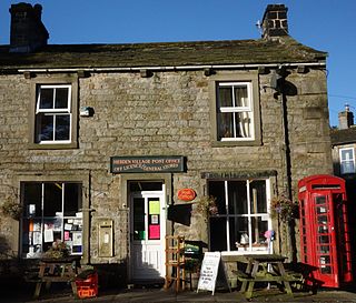
Hebden is a village and civil parish in the former Craven District of North Yorkshire, England, and one of four villages in the ecclesiastical parish of Linton. It lies near Grimwith Reservoir and Grassington, in Wharfedale in the Yorkshire Dales National Park. In 2011 it had a population of 246.
Thorpe is a hamlet and civil parish in Wharfedale, North Yorkshire, England. It is 2 miles (3 km) south of Grassington and 6 miles (10 km) north of Skipton. At the 2011 census the population remained less than 100, so the details were included in the civil parish of Burnsall. However in 2015, North Yorkshire County Council estimated the population to be 50.

Clitheroe Castle is a ruined early medieval castle in Clitheroe in Lancashire, England. It was the caput of the Honour of Clitheroe, a vast estate stretching along the western side of the Pennines.

The Burgsvik Beds are a sequence of shallow marine limestones and sandstones found near the locality of Burgsvik in the southern part of Gotland, Sweden. The beds were deposited in the Upper Silurian period, around 420 million years ago, in warm, equatorial waters frequently ravaged by storms, in front of an advancing shoreline. The Burgsvik Formation comprises two members, the Burgsvik Sandstone and the Burgsvik Oolite.
This glossary of geology is a list of definitions of terms and concepts relevant to geology, its sub-disciplines, and related fields. For other terms related to the Earth sciences, see Glossary of geography terms (disambiguation).
The geology of Lancashire in northwest England consists in the main of Carboniferous age rocks but with Triassic sandstones and mudstones at or near the surface of the lowlands bordering the Irish Sea though these are largely obscured by Quaternary deposits.

The Laborcita Formation is a geologic formation in the Sacramento Mountains of New Mexico. It preserves fossils dating back to the late Pennsylvanian to early Permian.
The Gasport Formation is a geologic formation in the Appalachian Basin and Michigan Basin. This is one of the reef formations separating the Appalachian Basin from the Michigan Basin and the Ohio Basin. It is a part of the Lockport Group of carbonates. It is the lowest and oldest formation within the Lockport. The Gasport is found in Michigan, New York, Ohio, and Pennsylvania. Outcrops are limited to the area around the Great Lakes. It is part of a large reef structure dating back to the Silurian period. Being part of the Lockport Group it is a feature of the Niagara Escarpment.
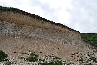
A Waulsortian mudmound is a calcareous geographical feature found in Early Carboniferous strata of Central Europe. It is a type of fossil-rich bioconstruction, formed by microbial activity in deep tropical waters during the mid-Dinantian. Mud mounds are a type of high-relief biologically-mediated seafloor deposit, similar to a reef. Unlike a true reef, a mud mound is composed almost entirely of uncemented mud-sized matrix grains, and the isolated fossils do not form a significant skeletal framework.
The Craven Basin is a sedimentary basin in northern England, having the shape of a southerly-tilted graben which was active during the Carboniferous period. It is one of a series of such basins which developed across northern England in this period separating upstanding blocks which were typically underlain by buoyant granites. The basin trends roughly east–west and is bounded by the Lake District block to the northwest, the Askrigg Block to the northeast and the Central Lancashire High to the south. One distinct section of the basin is a half graben which contains over 3km thickness of late Devonian to Courceyan strata and is referred to as the Bowland Sub-basin. These basins resulted from the crust of the region being subjected to a north–south lateral tension regime which began in the late Devonian and lasted through until the Visean.
The geology of the Peak District National Park in England is dominated by a thick succession of faulted and folded sedimentary rocks of Carboniferous age. The Peak District is often divided into a southerly White Peak where Carboniferous Limestone outcrops and a northerly Dark Peak where the overlying succession of sandstones and mudstones dominate the landscape. The scarp and dip slope landscape which characterises the Dark Peak also extends along the eastern and western margins of the park. Although older rocks are present at depth, the oldest rocks which are to be found at the surface in the national park are dolomitic limestones of the Woo Dale Limestone Formation seen where Woo Dale enters Wye Dale east of Buxton.
