The Pennines, also known as the Pennine Chain or Pennine Hills, is a range of hills and mountains separating North West England from Yorkshire and North East England.

The Yorkshire Dales is an upland area of the Pennines in the historic county of Yorkshire, England, most of it in the Yorkshire Dales National Park created in 1954.
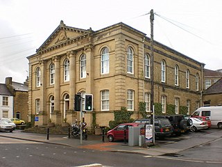
Craven is a local government district of North Yorkshire, England centred on the market town of Skipton. In 1974, Craven district was formed as the merger of Skipton urban district, Settle Rural District and most of Skipton Rural District, all in the West Riding of Yorkshire. The population of the Local Authority at the 2011 Census was 55,409. It comprises the upper reaches of Airedale, Wharfedale, Ribblesdale, and includes most of the Aire Gap and Craven Basin.
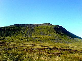
The mountains of Whernside, Ingleborough and Pen-y-ghent are collectively known as the Three Peaks. The peaks, which form part of the Pennine range, encircle the head of the valley of the River Ribble in the Yorkshire Dales National Park in the North of England.
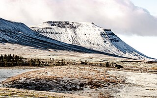
Ingleborough is the second-highest mountain in the Yorkshire Dales, England. It is one of the Yorkshire Three Peaks, and is frequently climbed as part of the Three Peaks walk.

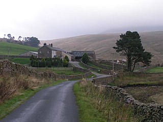
Ingleton is a village and civil parish in the Craven district of North Yorkshire, England. The village is 19 miles (30 km) from Kendal and 17 miles (28 km) from Lancaster on the western side of the Pennines. It is 9.3 miles (15 km) from Settle. The River Doe and the River Twiss meet to form the source of the River Greta, a tributary of the River Lune. The village is on the A65 road and at the head of the A687. The B6255 takes the south bank of the River Doe to Ribblehead and Hawes. All that remains of the railway in the village is the landmark Ingleton Viaduct. Arthur Conan Doyle was a regular visitor to the area and was married locally, as his mother lived at Masongill from 1882 to 1917. There is growing evidence to support a claim that the inspiration for the name Sherlock Holmes came from here.

Millstone Grit is the name given to any of a number of coarse-grained sandstones of Carboniferous age which occur in the British Isles. The name derives from its use in earlier times as a source of millstones for use principally in watermills. Geologists refer to the whole suite of rocks that encompass the individual limestone beds and the intervening mudstones as the Millstone Grit Group. The term Millstone Grit Series was formerly used to refer to the rocks now included within the Millstone Grit Group together with the underlying Edale Shale Group.

White Scar Caves is a show cave in the civil parish of Ingleton, North Yorkshire, England, under Ingleborough in the Chapel-le-Dale valley of the Yorkshire Dales National Park. It is a solutional resurgence cave formed in Carboniferous limestone, some 6 kilometres (3.7 mi) long.

The River Twiss is a river in the county of Yorkshire, England. The source of the river is Kingsdale Beck which rises at Kingsdale Head at the confluence of Back Gill and Long Gill in the Yorkshire Dales. Beneath Keld Head, it changes its name to the River Twiss. It has two notable waterfalls, Thornton Force and Pecca Falls, and its course follows part of the Ingleton Waterfalls Walk, then through Swilla Glen to Thornton in Lonsdale and down to Ingleton, where it meets the River Doe to form the River Greta.

Ingleton Waterfalls Trail is a well-known circular trail beginning and ending in the village of Ingleton in the English county of North Yorkshire, now maintained by the Ingleton Scenery Company. It is claimed that the trail, some 8 kilometres (5 mi) long, and with a vertical rise of 169 m (554 feet) has some of the most spectacular waterfall and woodland scenery in the north of England. It is on private land and an entrance fee is charged.

The mountains and hills of England comprise very different kinds of terrain, from a mountain range which reaches almost 1,000 metres high, to several smaller areas of lower mountains, foothills and sea cliffs. Most of the major upland areas have been designated as Areas of Outstanding Natural Beauty (AONB) or national parks. The highest and most extensive areas are in the north and west, while the south-east and east of the country tend to be low-lying.

The South Pennines is a region of moorland and hill country in northern England lying towards the southern end of the Pennines. In the west it includes the Rossendale Valley and the West Pennine Moors. It is bounded by the Greater Manchester conurbation in the west and the Bowland Fells and Yorkshire Dales to the north. To the east it is fringed by the towns of West Yorkshire whilst to the south it is bounded by the Peak District. The rural South Pennine Moors constitutes both a Site of Special Scientific Interest and Special Area of Conservation.

The Geology of Yorkshire in northern England shows a very close relationship between the major topographical areas and the geological period in which their rocks were formed. The rocks of the Pennine chain of hills in the west are of Carboniferous origin whilst those of the central vale are Permo-Triassic. The North York Moors in the north-east of the county are Jurassic in age while the Yorkshire Wolds to the south east are Cretaceous chalk uplands. The plain of Holderness and the Humberhead levels both owe their present form to the Quaternary ice ages. The strata become gradually younger from west to east.
The Askrigg Block is the name applied by geologists to the crustal block forming a part of the Pennines of northern England and which is essentially coincident with the Yorkshire Dales. It is defined by the Dent Fault to the west and the Craven Fault System to the south whilst to the north it is separated from the Alston Block by the Stainmore Trough. It originated as a geological structure during the Carboniferous Period as a major element in the Pennine Block & Basin Province.

The Dent Fault is a major fault zone on the boundary between the counties of Cumbria and North Yorkshire in northern England. It is named after the village of Dent in Dentdale, on the western margin of the Yorkshire Dales.

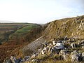
Aire Gap is a pass through the Pennines in England formed by geologic faults and carved out by glaciers. The term is used to describe a geological division, a travel route, or a location that is an entry into the Aire river valley.

Feizor is a hamlet in the Yorkshire Dales National Park, England. The name means "Fech's summer pasture" probably in reference to a prominent local landowner whose name was recorded at the time of the Norman conquest.
Kingsdale is a valley on the western edge of the Yorkshire Dales National Park in northern England. The name Kingsdale derives from a combination of Old Norse and Old English which means The valley where the cows were kept. Humans were active in Kingsdale from 6,700 BC onwards. Evidence of fire-pits used by hunter-gatherers have been found in the dale.
The geology of Lancashire in northwest England consists in the main of Carboniferous age rocks but with Triassic sandstones and mudstones at or near the surface of the lowlands bordering the Irish Sea though these are largely obscured by Quaternary deposits.
The Craven Basin is a sedimentary basin in northern England, having the shape of a southerly-tilted graben which was active during the Carboniferous period. It is one of a series of such basins which developed across northern England in this period separating upstanding blocks which were typically underlain by buoyant granites. The basin trends roughly east–west and is bounded by the Lake District block to the northwest, the Askrigg Block to the northeast and the Central Lancashire High to the south. One distinct section of the basin is a half graben which contains over 3km thickness of late Devonian to Courceyan strata and is referred to as the Bowland Sub-basin. These basins resulted from the crust of the region being subjected to a north–south lateral tension regime which began in the late Devonian and lasted through until the Visean.