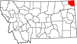
Reserve, Montana | |
---|---|
Coordinates: 48°36′19″N104°27′50″W / 48.60528°N 104.46389°W | |
Country | United States |
State | Montana |
County | Sheridan |
Area | |
• Total | 1.35 sq mi (3.49 km2) |
• Land | 1.35 sq mi (3.49 km2) |
• Water | 0.00 sq mi (0.00 km2) |
Elevation | 1,959 ft (597 m) |
Population (2020) | |
• Total | 33 |
• Density | 24.46/sq mi (9.44/km2) |
Time zone | UTC-7 (Mountain (MST)) |
• Summer (DST) | UTC-6 (MDT) |
ZIP code | 59258 |
Area code | 406 |
FIPS code | 30-62125 |
GNIS feature ID | 0775712 |
Reserve is a census-designated place (CDP) in Sheridan County, Montana, United States. The population was 23 at the 2010 census. [2]
The town of Wakea was platted in 1911. The name was changed in 1912 with the establishment of the post office. The name comes from the proximity to the Fort Peck Indian Reservation. [3]
Reserve is located at 48°36′19″N104°27′50″W / 48.60528°N 104.46389°W (48.605251, -104.463969). [4]
According to the United States Census Bureau, the CDP has a total area of 1.4 square miles (3.6 km2), all land.
Census | Pop. | Note | %± |
---|---|---|---|
2020 | 33 | — | |
U.S. Decennial Census [5] |
As of the census [6] of 2000, there were 37 people, 18 households, and 10 families residing in the CDP. The population density was 26.9 inhabitants per square mile (10.4/km2). There were 25 housing units at an average density of 18.2 per square mile (7.0/km2). The racial makeup of the CDP was 97.30% White and 2.70% Native American. Hispanic or Latino of any race were 2.70% of the population.
There were 18 households, out of which 27.8% had children under the age of 18 living with them, 61.1% were married couples living together, and 38.9% were non-families. 33.3% of all households were made up of individuals, and 11.1% had someone living alone who was 65 years of age or older. The average household size was 2.06 and the average family size was 2.64.
In the CDP, the population was spread out, with 18.9% under the age of 18, 2.7% from 18 to 24, 13.5% from 25 to 44, 35.1% from 45 to 64, and 29.7% who were 65 years of age or older. The median age was 50 years. For every 100 females, there were 76.2 males. For every 100 females age 18 and over, there were 87.5 males.
The median income for a household in the CDP was $33,750, and the median income for a family was $30,000. Males had a median income of $13,750 versus $30,000 for females. The per capita income for the CDP was $13,742. There were 41.7% of families and 33.3% of the population living below the poverty line, including 40.0% of under eighteens and 66.7% of those over 64.
Discovery-Spring Garden is a former census-designated place in Frederick County, Maryland, United States. It is the combination of the two unincorporated communities of Discovery and Spring Garden. As of the 2000 census, the population was 2,152; its population was not counted in 2010.
Hays is a census-designated place (CDP) in Blaine County, Montana, United States. The population was 843 at the 2010 census. The community lies within the Fort Belknap Indian Reservation, near the reservation's southern end. The nearby community of Lodge Pole lies to the east.
Fort Shaw is a census-designated place (CDP) in Cascade County, Montana, United States. The population was 280 at the 2010 census. Named for a former United States military outpost, it is part of the Great Falls, Montana Metropolitan Statistical Area.
Martin City is an unincorporated community and census-designated place (CDP) in Flathead County, Montana, United States. As of the 2010 census, it had a population of 500, up from 331 in 2000.
North Browning is a census-designated place (CDP) in Glacier County, Montana, United States. The population was 2,408 at the 2010 census.
South Browning is a census-designated place (CDP) in Glacier County, Montana, United States. The population was 1,785 at the 2010 census. South Browning is a rural village on the Blackfeet Indian Reservation. It is bordered to the north by the town of Browning.
Starr School is a census-designated place (CDP) in Glacier County, Montana, United States. The population was 252 at the 2010 census.
Herron is a census-designated place (CDP) in Hill County, Montana, United States. The population was 43 at the 2010 census.
Inverness is a census-designated place (CDP) in Hill County, Montana, United States. The population was 55 at the 2010 census. It was named after a town in Scotland.
Kremlin is an unincorporated community and census-designated place (CDP) in Hill County, Montana, United States. The population was 98 at the 2010 census, down from 126 in 2000.
Rudyard is an unincorporated community and census-designated place (CDP) in Hill County, Montana, United States. The population was 258 at the 2010 census.
West Havre is a census-designated place (CDP) in Hill County, Montana, United States. The population was 316 at the 2010 census, up from 284 in 2000.
Rocky Point is a census-designated place (CDP) in Lake County, Montana, United States. The population was 97 at the 2010 census.
Fortine is a census-designated place (CDP) in Lincoln County, Montana, United States. The population was 206 at the 2021 census.
Alder is a census-designated place (CDP) in Madison County, Montana, United States. The population was 86 at the 2020 census. The community takes its name from Alder Creek, the site of the second major gold discovery in Montana.
East Missoula is a census-designated place (CDP) in Missoula County, Montana, United States. It is part of the 'Missoula, Montana Metropolitan Statistical Area'. The population was 2,157 at the 2010 census, an increase from its population of 2,070 in 2000.
Avon is a census-designated place (CDP) in Powell County, Montana, United States. The population was 124 at the 2000 census. The town sits along the Little Blackfoot River, and serves as a gateway to the Beaverhead-Deerlodge National Forest.
Elliston is a census-designated place (CDP) in Powell County, Montana, United States. The population was 225 at the 2000 census.
Joplin is a unincorporated community and census-designated place (CDP) in Liberty County, Montana, United States. The population was 157 at the 2010 census.
Fox Lake is a census-designated place (CDP) in Richland County, Montana, United States. The population was 158 at the 2010 census.