The Warrumbungle Shire is a local government area in the central western region of New South Wales, Australia. The Shire is traversed by the Newell Highway. The Warrumbungle mountain range and Warrumbungles National Park are major tourist attractions for the Shire. Its seat is located in Coonabarabran, a town in the southwest.

Leeton Shire is a local government area in the Riverina region of New South Wales, Australia. The Shire is located adjacent to the Murrumbidgee River and falls within the Murrumbidgee Irrigation Area.

Narromine Shire is a local government area in the Orana region of New South Wales, Australia. The Shire is located adjacent to the Mitchell Highway and the Main Western railway line. It was formed on 1 January 1981 from the amalgamation of the Municipality of Narromine and Timbrebongie Shire resulting from the Local Government Areas Amalgamation Act 1980.

Berrigan Shire is a local government area in the southern Riverina region of New South Wales, Australia. The Shire lies on the New South Wales State border with Victoria formed by the Murray River. The Shire is adjacent to the Newell and Riverina Highways. The Shire is a mainly agricultural region, with dairying, cattle raising, woolgrowing and cropping the main activities. The vast majority of the Shire is irrigated. Tourism is another major activity, concentrated on the river towns of Tocumwal and Barooga.

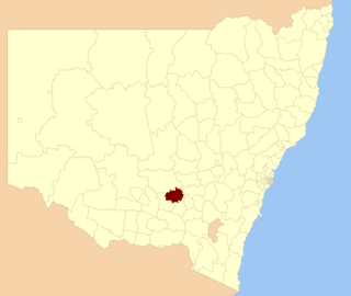
The Cowra Shire is a local government area in the Central West region of New South Wales, Australia. The Shire is located adjacent to the Lachlan River, the Mid-Western Highway and the Lachlan Way.

The City of Dubbo was a local government area in the Orana region of New South Wales, Australia. The former area is located adjacent to the Mitchell, Newell, and the Golden highways, the Main Western railway line, and the Macquarie River.

The Junee Shire is a local government area in the Riverina region of New South Wales, Australia. The Shire comprises an area of 2,030 square kilometres (780 sq mi) and is located adjacent to the Olympic Highway and the Main South railway line. It was formed on 1 January 1981 from the amalgamation of the Municipality of Junee and Illabo Shire resulting from the Local Government Areas Amalgamation Act 1980.
Temora Shire is a local government area in the Riverina region of New South Wales, Australia. It is on Burley Griffin Way. The Shire was created on 1 January 1981 via the amalgamation of Narraburra Shire and the Municipality of Temora.
Wellington Council was a local government area in the Orana region of New South Wales, Australia. The former area is located adjacent to the Macquarie River and the Mitchell Highway.

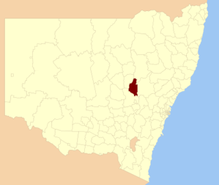
Gilgandra Shire is a local government area in the Orana region of New South Wales, Australia. The Shire is located adjacent to the junction of the Newell, Oxley and Castlereagh highways and can be reached in about six hours by car from Sydney CBD. The Shire lies on the Castlereagh River and includes part of the Warrumbungles National Park. The shire was constituted in 1906.
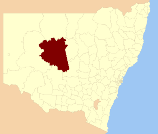
Cobar Shire is a local government area in the Orana region of New South Wales, Australia. The Shire is located in an outback area that is centred around the mining town of Cobar. The Shire is traversed by the Barrier Highway and the Kidman Way. With a total area of 44,065 square kilometres (17,014 sq mi), about two-thirds the size of Tasmania, Cobar Shire is larger than Denmark and 99 other countries and self-governing territories, but its population is under 5000.

Orana is a vast region in north-central New South Wales, Australia. As of June 2015 it had an estimated population of 113,824 people. It has an area of 198,561 square kilometres (76,665 sq mi) and is the largest region in New South Wales, comprising approximately 25% of that state. The major localities include Dubbo and Cobar. This region corresponds approximately with the Australian Bureau of Statistics North Western Statistical Division.

The Dubbo Regional Council is a local government area located in the Central West and Orana regions of New South Wales, Australia. The council was formed on 12 May 2016 through a merger of the City of Dubbo and Wellington Council as part of a widespread council amalgamation program. It was initially named Western Plains Regional Council for almost four months, and its name was changed to Dubbo Regional Council on 7 September 2016.
This is a list of results for the 2021 New South Wales local elections in the Riverina region.
This is a list of results for the 2021 New South Wales local elections in the New England region, including the North West.
This is a list of results for the 2021 New South Wales local elections in the Orana region.
This is a list of results for the 2024 New South Wales local elections in the Murray region, including the Far West.
This is a list of results for the 2024 New South Wales local elections in the New England region, including the North West.
This is a list of results for the 2024 New South Wales local elections in the Riverina region.
This is a list of results for the 2024 New South Wales local elections in the South Coast and Southern Inland region.