Related Research Articles
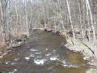
Little Wapwallopen Creek is a tributary of the Susquehanna River in Luzerne County, Pennsylvania, in the United States. It is approximately 17 miles (27 km) long and flows through Rice Township, Dorrance Township, Conyngham Township, and Hollenback Township. The watershed of the creek has an area of 39.5 square miles (102 km2). The creek is designated as a Coldwater Fishery and a Migratory Fishery and is not considered to be impaired. It has two named tributaries: Pond Creek and Nuangola Outlet. Wild trout naturally reproduce in the creek.

Phillips Creek is a tributary of Huntington Creek in Luzerne County, Pennsylvania, in the United States. It is approximately 5.3 miles (8.5 km) long and flows through Fairmount Township. The watershed of the creek has an area of 5.54 square miles (14.3 km2) and has no named tributaries. The creek is considered by the Pennsylvania Fish and Boat Commission to be Class A Wild Trout Waters for brook trout throughout its entire length. Glacial till, alluvium, sandstone, and shale can be found in its vicinity. Its course has been altered by glaciation and it is in the vicinity of North Mountain. At least one bridge has been built over the creek and a number of hunting cabins and cottages existed in the area. The creek's discharge has a 10 percent chance of reaching 915 cubic feet per second in any given year.
Bow Creek is a tributary of Big Wapwallopen Creek in Luzerne County, Pennsylvania, in the United States. It is approximately 4.5 miles (7.2 km) long and flows through Fairview Township and Wright Township. The watershed of the creek has an area of 4.69 square miles (12.1 km2). The creek has no named tributaries, but several unnamed ones, such as Bow Creek Tributary A. Bow Creek has been historically nearly devoid of life, but is now considered to be Class A Wild Trout Waters. There is a bridge carrying Pennsylvania Route 309 across the creek. Wisconsinan Till, alluvium, and bedrock consisting of sandstone, shale, conglomerate, and coal occur in the watershed. Several volatile organic compounds have been detected in small amounts in surface water in the watershed. The creek occasionally floods, but such flooding typically causes little damage.
Rocky Run is a tributary of the Susquehanna River in Luzerne County, Pennsylvania, in the United States. It is approximately 2.3 miles (3.7 km) long and flows through Salem Township. The watershed of the stream has an area of 1.83 square miles (4.7 km2). In the early 1900s, the stream had a high level of water quality and was proposed for use as a water supply. The construction of a dam on it was proposed, but no formal plans were ever made. There are coal mines in the watershed, but they have been abandoned since the late 1800s. Wisconsinan Till, Wisconsinan Ice-Contact Stratified Drift, Boulder Colluvium, Wisconsinan Bouldery Till, coal dumps, and bedrock consisting of sandstone and shale all occur in the watershed. The drainage basin is designated as a Coldwater Fishery.
Culver Creek is a tributary of Shickshinny Creek in Luzerne County, Pennsylvania, in the United States. It is approximately 1.1 miles (1.8 km) long and flows through Ross Township and Union Township. The watershed of the creek has an area of 1.10 square miles (2.8 km2). It is designated as a Coldwater Fishery and a Migratory Fishery. The surficial geology along the creek and in its vicinity consists of Wisconsinan Till, Wisconsinan Bouldery Till, alluvial fan, and bedrock consisting of sandstone and shale.

Hunlock Creek is a tributary of the Susquehanna River in Luzerne County, Pennsylvania, in the United States. It is approximately 7.8 miles (12.6 km) long and flows through Lehman Township and Hunlock Township. The watershed of the creek has an area of 32.5 square miles (84 km2) and is situated in northwestern Luzerne County. It has one named tributary, which is known as Roaring Brook, and a number of unnamed and unofficially named tributaries, such as "West Branch Hunlock Creek".
Drakes Creek is a tributary of East Fork Harveys Creek in Luzerne County, Pennsylvania, in the United States. It is approximately 2.2 miles (3.5 km) long and flows through Jackson Township. The watershed of the creek has an area of 2.10 square miles (5.4 km2). In 1974, the creek itself was described as having "excellent" water quality. The surficial geology in its watershed features Wisconsinan Till, Wisconsinan Ice-Contact Stratified Drift, and bedrock consisting of sandstone, conglomeratic sandstone, shale, and coal.

Pikes Creek is a tributary of Harveys Creek in Luzerne County, Pennsylvania, in the United States. It is approximately 8.9 miles (14.3 km) long and flows through Lake Township, Lehman Township, Jackson Township, and Plymouth Township. The watershed of the creek has an area of 11.6 square miles (30 km2). It is designated as a High-Quality Coldwater Fishery and a Migratory Fishery, as well as being Class A Wild Trout Waters for part of its length. The creek has a 400-acre reservoir, which is known as the Pikes Creek Reservoir and supplies water to tens of thousands of people. A number of bridges have been constructed over the creek.

Fades Creek is a tributary of Pikes Creek in Luzerne County, Pennsylvania, in the United States. It is approximately 3.2 miles (5.1 km) long and flows through Lake Township. The watershed of the creek has an area of 2.07 square miles (5.4 km2). It has one unnamed tributary and is designated as a High-Quality Coldwater Fishery and Class A Wild Trout Waters for part of its length. The creek is crossed by a pipeline and a bridge carrying Pennsylvania Route 118. Wisconsinan Ice-Intact Stratified Drift, alluvium, Wisconsinan Till, Wisconsinan Bouldery Till, and bedrock consisting of sandstone and shale all occur in the surficial geology in the creek's vicinity.

Huntsville Creek is a tributary of Toby Creek in Luzerne County, Pennsylvania, in the United States. It is approximately 7.5 miles (12.1 km) long and flows through Dallas Township, Dallas, Lehman Township, Jackson Township, and Kingston Township. The watershed of the creek has an area of 14.7 square miles (38 km2). It is designated as a Coldwater Fishery and a Migratory Fishery. Wisconsinan Till, Wisconsinan Ice-Contact Stratified Drift, alluvium, sandstone and shale pits, and bedrock consisting of sandstone and shale all occur in the watershed. A 2-billion gallon reservoir known as the Huntsville Reservoir is situated on the creek. The reservoir supplies water to 30,000 people. The creek has one named tributary, which is known as Browns Creek.
Browns Creek is a tributary of Huntsville Creek in Luzerne County, Pennsylvania, in the United States. It is approximately 3.6 miles (5.8 km) long and flows through Lehman Township and Jackson Township. The watershed of the creek has an area of 3.86 square miles (10.0 km2). The watershed is less developed than that of Toby Creek, but is beginning to urbanize. Wisconsinan Till, Wisconsinan Ice-Contact Stratified Drift, alluvium, sandstone and shale pits, and bedrock consisting of sandstone and shale all occur in the watershed.

Rogers Creek is a tributary of Huntington Creek, in Luzerne County, Pennsylvania, in the United States. It is approximately 2.9 miles (4.7 km) long and flows through Ross Township and Huntington Township. The watershed of the creek has an area of 7.10 square miles (18.4 km2). It is designated as a Coldwater Fishery and a Migratory Fishery. The creek flows through a broad valley in some locations and a gorge in other locations. A number of mills were built along it in the late 1700s.
Little Nescopeck Creek is a tributary of Nescopeck Creek in Luzerne County, Pennsylvania, in the United States. It is approximately 8.2 miles (13.2 km) long and flows through Bear Creek Township, Fairview Township, and Dennsion Township. The watershed of the creek has an area of 10.7 square miles (28 km2). The creek has one named tributary, which is known as Conety Run. Little Nescopeck Creek is designated as a Coldwater Fishery and Class A Wild Trout Waters. It is one of the main sources of flooding in Dennison Township. The surficial geology in the vicinity of the creek mainly features alluvium, Wisconsinan Till, Wisconsinan Ice-Contact Stratified Drift, bedrock, and fill. Little Nescopeck Creek shares its name with another river in southern Luzerne county.

Marsh Creek is a tributary of Rogers Creek in Luzerne County, Pennsylvania, in the United States. It is approximately 4.0 miles (6.4 km) long and flows through Ross Township. The watershed of the creek has an area of 4.04 square miles (10.5 km2). Wild trout naturally reproduce within the creek. At least one bridge crosses the creek and the community of Broadway and several wetlands are in the watershed. The surficial geology in the creek's vicinity consists of Wisconsinan Till, Wisconsinan Ice-Contact Stratified Drift, alluvium, wetlands, and bedrock.

Black Ash Creek is a tributary of Rogers Creek in Luzerne County, Pennsylvania, in the United States. It is approximately 1.9 miles (3.1 km) and flows through Ross Township. The watershed of the creek has an area of 1.46 square miles (3.8 km2). The creek is not impaired. The surficial geology in its vicinity consists of alluvium, Wisconsinan Outwash, Wisconsinan Till, and bedrock.
Gardner Creek is a tributary of the Susquehanna River in Lackawanna County, Pennsylvania, in the United States. It is approximately 9.1 miles (14.6 km) long and flows through Newton Township and Ransom Township. The watershed of the creek has an area of 18.1 square miles (47 km2). The creek is not designated as an impaired waterbody. The surficial geology in its vicinity mainly consists of alluvial terrace, alluvium, Wisconsinan Till, and bedrock. However, Wisconsinan Ice-Contact Stratified Drift, fill, alluvial fan, peat, and wetlands also occur. The creek is the main source of flooding in Ransom Township.

Sutton Creek is a tributary of the Susquehanna River in Luzerne County, Pennsylvania, in the United States. It is approximately 7.6 miles (12.2 km) long and flows through Dallas Township, Franklin Township, and Exeter Township. The watershed of the creek has an area of 11.6 square miles (30 km2). The creek has one named tributary, which is known as Cider Run. Sutton Creek is located a few miles upriver of the Wyoming Valley. The surficial geology in its watershed consists of alluvium, Wisconsinan Till, Wisconsinan Ice-Contact Stratified Drift, and bedrock, while the bedrock geology consists of sandstone.
Beaver Run is a tributary of Bowman Creek in Luzerne County and Wyoming County, in Pennsylvania, in the United States. It is approximately 7.7 miles (12.4 km) long and flows through Lake Township in Luzerne County and Noxen Township in Wyoming County. The watershed of the stream has an area of 10.6 square miles (27 km2). It is not designated as an impaired waterbody. The surficial geology in its vicinity includes alluvial fan, alluvial terrace, alluvium, Wisconsinan Till, Wisconsinan Ice-Contact Stratified Drift, fill, wetlands, and bedrock.
Dundaff Creek is a tributary of East Branch Tunkhannock Creek in Susquehanna County and Lackawanna County, in Pennsylvania, in the United States. It is approximately 6.7 miles (10.8 km) long and flows through Clifford Township in Susquehanna County and Greenfield Township in Lackawanna County. The watershed of the creek has an area of 10.3 square miles (27 km2). The creek has no named tributaries and is not designated as an impaired waterbody.
References
- 1 2 3 United States Geological Survey, The National Map Viewer , retrieved January 20, 2015
- 1 2 Pennsylvania Gazetteer of Streams (PDF), November 2, 2001, p. 119, retrieved January 20, 2015
- 1 2 3 Federal Emergency Management Agency, Flood Insurance Study VOLUME 1 of 6 LUZERNE COUNTY, PENNSYLVANIA (ALL JURISDICTIONS) (PDF), p. 53, archived from the original (PDF) on April 2, 2015, retrieved January 20, 2015Cite uses deprecated parameter
|deadurl=(help) - 1 2 3 Geographic Names Information System, Feature Detail Report for: Reyburn Creek , retrieved January 20, 2015
- ↑ United States Nuclear Regulatory Commission, Generic Environmental Impact Statement for License Renewal of Nuclear Plants Supplement 35 United States Nuclear Regulatory Commission Protecting People and the Environment Generic Environmental Impact Statement for License Renewal of Nuclear Plants Supplement 35 Regarding Susquehanna Steam Electric Station, Units 1 and 2 Draft Report for Comment (PDF), p. 66, retrieved January 20, 2015
- 1 2 Duane D. Braun (2008), Surficial geology of the Shickshinny 7.5-minute quadrangle, Columbia and Luzerne Counties, Pennsylvania, p. 21, retrieved January 20, 2015
- ↑ Borton-Lawson (June 30, 2010), Luzerne County Act 167 Phase II Stormwater Management Plan (PDF), p. 162, archived from the original (PDF) on December 29, 2014, retrieved January 20, 2015Cite uses deprecated parameter
|deadurl=(help) - ↑ Discovering wild trout: 3,600-plus on protected list; 86 waters in county, Times Leader, May 29, 2011, retrieved January 20, 2015
- ↑ "NOTICES 2011 Classification of Wild Trout Streams; Additions, Adjustments and Deletions", www.pabulletin.com, Pennsylvania Bulletin, March 5, 2011, retrieved January 20, 2015
- ↑ § 93.9k. Drainage List K. Susquehanna River Basin in Pennsylvania Susquehanna River, Pennsylvania Code , retrieved January 20, 2015
- ↑ Pennsylvania Fish and Boat Commission (May 2014), Pennsylvania Wild Trout Waters (Natural Reproduction) - May 2014 (PDF), p. 49, retrieved January 20, 2015