
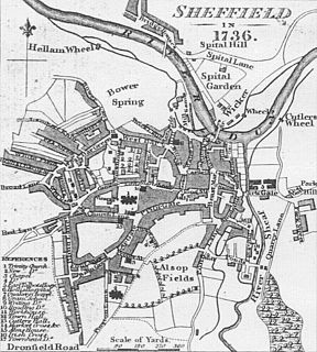
Reynaldthorpe was a village located near Sheffield, in present-day South Yorkshire, England. The village was located near the current suburb of Shiregreen. [1]
Reynaldthorpe was a village located near Sheffield, in present-day South Yorkshire, England. The village was located near the current suburb of Shiregreen. [1]
During the 13th century, the village featured a hall that stood between Sheffield Lane Top and Shiregreen Lane. The hamlets of Over Hartley and Hartley Brook stood to the north, in the parish of Ecclesfield. [2]
Charters held in the British Museum make several references to Reynaldthorpe, over the period between the 13th and 15th centuries, making reference to a hall, pastures, woodland and crofts. In a charter from 1303 it is clear that the Knights Hospitallers of St John of Jerusalem in England held lands at Reynaldthorpe. The next mention of the village is in 1412, followed by the 1637 survey of the Manor of Sheffield, in which it is recorded that Margaret Trickett is the occupant of 'Reynaldthorpe Hall, alias Hadfield Farme'. [3]
In 1637, Reynaldthorpe Hall (later Hadfield Farme), along with its outbuildings and adjoining land, was part of the demesne lands of the manor of Sheffield. Prior to 1719, Hadfield Farme became Hadfield House and was occupied by William Hunter (great great grandfather of Antiquarian Joseph Hunter). [4]
In recent years, the hall has been removed, and the village, hall and hamlets are only remembered in local street names including 'Hadfield House Lane' and 'Hartley Brook Road'. [5]
Glossop is a market town in the High Peak, Derbyshire, England, 15 miles (24 km) east of Manchester, 24 miles (39 km) northwest of Sheffield and 32 miles (51 km) north of the county town, Matlock, near Derbyshire's borders with Cheshire, Greater Manchester, South Yorkshire and West Yorkshire. It is between 150 and 300 metres above mean sea level, and is bounded by the Peak District National Park to the south, east and north.
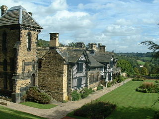
Shibden is a small dispered community in Calderdale West Yorkshire, England. Shibden Hall has a north-west driveway to its lake, café and miniature railway; an adjoining driveway runs up a landscaped garden to the hall which hosts the West Yorkshire Folk Museum. The land sits on a north-south rise between deep brooks, shared with more populous Southowram to the south.

Hallamshire is the historical name for an area of South Yorkshire, England, in the current city of Sheffield.

Sheffield Castle was a castle in Sheffield, England, constructed at the confluence of the River Sheaf and the River Don, possibly on the site of a former Anglo-Saxon long house, and dominating the early town. A motte and bailey castle had been constructed on the site at some time in the century following the Norman Conquest of England in 1066. This was destroyed in the Second Barons' War. Construction of a second castle, this time in stone, began four years later in 1270.

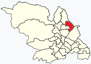
Nether Edge and Sharrow Ward includes the districts of Brincliffe, Carter Knowle, Nether Edge, Sharrow Vale, and most of Banner Cross, and is one of the 28 electoral wards in the City of Sheffield, England. It is located in the southern part of the city and covers an area of 1.31 square miles (3.4 km2). In 2011, the population of this ward was 18,890 people in 7,592 households. Nether Edge ward is one of the wards that make up the Sheffield Central parliamentary constituency.

Ringinglow is a village in the western section of Sheffield, England. It is on the western border of Ecclesall Ward, and although it is within the boundary of Sheffield, it is self-contained, being entirely surrounded by open countryside. The village now falls within the Fulwood ward of the City.
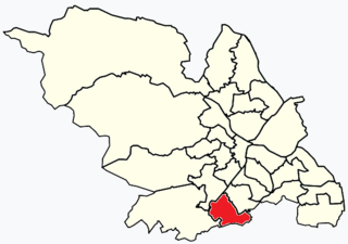
Beauchief and Greenhill ward—which includes the districts of Batemoor, Beauchief, Chancet Wood, Greenhill, Jordanthorpe, and Lowedges—is one of the 28 electoral wards in City of Sheffield, England. It is located in the southern part of the city and covers an area of 2.4 square miles (6.2 km2). The population of this ward in 2016 was estimated to be 19,669 people in 9,209 houses.

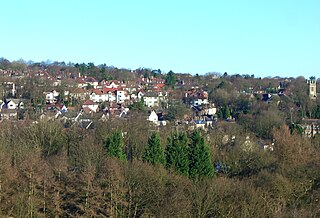
Whirlow is a suburb of the City of Sheffield in England, it lies 3.7 miles (6 km) south-west of the city centre. The suburb falls within the Dore and Totley ward of the City. It is one of the most affluent areas of Sheffield, with much high class housing and several notable small country houses within it. During the Victorian era it was home to some of Sheffield's most influential citizens. Whirlow straddles the A625, the main Sheffield to Hathersage road. The suburb covers the area from Parkhead in the north to Whirlow Bridge in the south and from Ecclesall Woods in the east to Broad Elms Lane in the west. Whirlow had a population of 1,663 in 2011.

The areas of Sheffield, a city and metropolitan borough in the north of England, vary widely in size and history. Some of the areas developed from villages or hamlets, that were absorbed into Sheffield as the city grew, and thus their centres are well defined, but the boundaries of many areas are ambiguous. The areas of Sheffield do not play a significant administrative role, but the city is divided into 28 electoral wards for local elections and 6 parliamentary constituencies for national elections.
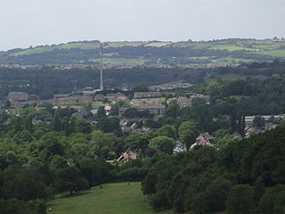
Shiregreen and Brightside ward—which includes the districts of Brightside, Shiregreen, and Wincobank—is one of the 28 electoral wards in City of Sheffield, England. It is located in the northern part of the city and covers an area of 6.5 km2. The population of this ward in 2011 was 20,826 people in 8,696 households. It is one of the wards making up the Sheffield Brightside parliamentary constituency.
The area known as Sheffield was probably founded in the second half of 1AD in a clearing by the River Sheaf although humans may have lived in the area for at least 10,000 years.
This timeline of Sheffield history summarises key events in the history of Sheffield, a city in England. The origins of the city can be traced back to the founding of a settlement in a clearing beside the River Sheaf in the second half of the 1st millennium AD. The area had seen human occupation since at least the last ice age, but significant growth in the settlements that are now incorporated into the city did not occur until the industrial revolution.

The Blackburn Brook is a stream in Sheffield, South Yorkshire, England which flows through the Blackburn Valley along the M1 and Ecclesfield Road and joins the River Don near the Meadowhall shopping centre. Downstream from the A61 road at Chapeltown the Blackburn Brook is defined as a main river by the Environment Agency, which requires new building development to be at least 8m from the bank side as a flood defence measure and to allow access to the watercourse for maintenance.

The Limb Brook is a stream in Sheffield, South Yorkshire, England. It rises at the village of Ringinglow, flowing east through Whirlow and Ecclesall Woods into Abbeydale in the Beauchief area, where it merges with the River Sheaf. Near this point part of the stream has been diverted to provide the goit for the Abbeydale Industrial Hamlet millpond, and this channel flows through what is now Beauchief Gardens.

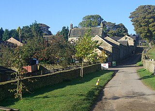
Dungworth is a hamlet in the civil parish of Bradfield, west of Sheffield in South Yorkshire, England.

Mosborough is a village 7 miles south east of Sheffield’s city centre, now classed as a historic township of the city. The town was named after The Moss river that flows through the area. Due to much expansion, the village became a part of Sheffield city in 1967. During much of the late 19th and 20th centuries the village was noted for its steelmaking, with Hutton & Co. Sickle works being based at nearby Ridgeway.

Parkhead Hall, formerly Parkhead House and The Woodlands, is an English country house situated in the City of Sheffield in South Yorkshire. The hall is a grade II listed building and is located in the suburb of Whirlow close to the junction of Ecclesall Road South and Abbey Lane. The hall is difficult to view for the general public, being surrounded by high walls and housing, although a glimpse of its northern side can be seen from Ecclesall Road South.
Whirlow Hall Farm is a working farm situated on Broad Elms Lane at Whirlow in the City of Sheffield, England. Since 1979 it has been the site of the Whirlow Hall Farm Trust, a registered charity which allows children and young people to visit a working farm. The site includes various Grade II listed buildings including Whirlow Farmhouse built on the site of the old Whirlow Hall. In the yard below the farmhouse is Whirlow Hall Cottage along with two ancient cruck barns and a cow shed.
Fulwood is a residential suburb and ward of the City of Sheffield in England, it lies 5.5 km west-southwest of the city centre. Formerly an ancient settlement and village on the Porter Brook, it became integrated into the city in the 1930s. It is bounded by the suburbs of Lodge Moor to the NW, Ranmoor to the east and Crosspool to the NE. The open countryside of the Peak District lies to the west and SW. The sub districts of Stumperlowe and Goole Green are part of the suburb. The population of the ward at the 2011 Census was 18,233. Fulwood is located in the Sheffield Hallam constituency which, as of the 2019 general election voted Labour.

Broomhead Hall was a large English country house that stood in the Ewden valley, to the west of Sheffield, England. The hall stood near the hamlet of Wigtwizzle, to the west of Broomhead Reservoir.