Franklin County is a county in the U.S. state of Nebraska. As of the 2010 census, the population was 3,225. Its county seat is Franklin. The county was formed in 1867 and organized in 1871. It was named for Benjamin Franklin.

Riley County is a county located in the U.S. state of Kansas. As of the 2020 census, the population was 71,959. The largest city and county seat is Manhattan.

Linn County is a county located in east-central Kansas and is part of the Kansas City metropolitan area. As of the 2020 census, the county population was 9,591. Its county seat is Mound City, and its most populous city is Pleasanton. The county was named for Lewis F. Linn, a U.S. Senator from Missouri.

Johnson County is a county in the U.S. state of Kansas, on the border with Missouri. As of the 2020 census, the population was 609,863, making it the most populous county in Kansas. Its county seat is Olathe. Largely suburban, the county contains a number of suburbs of Kansas City, Missouri, including Overland Park, the second most populous city in the Kansas City Metropolitan Area. The county is home to the headquarters of Garmin and AMC Theatres.

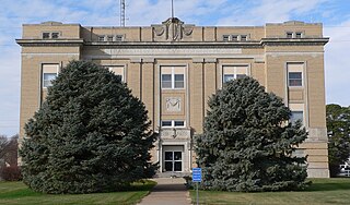
Franklin County is a county located in the eastern portion of the U.S. state of Kansas. As of the 2020 census, the county population was 25,996. Its county seat and most populous city is Ottawa. The county is predominantly rural. Formerly it was a part of the Kansas City metropolitan area, but was removed in 2013.

Xenia is an unincorporated community in Franklin Township, Bourbon County, Kansas, United States.

This is a list of the National Register of Historic Places listings in Franklin County, Kansas.
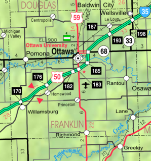
LeLoup is an unincorporated community in Franklin County, Kansas, United States. It is located a mile and half north of Interstate 35 on Tennessee Road, 11 miles northeast of Ottawa, 7 miles southwest of Wellsville.

Franklin is an unincorporated community in Crawford County, Kansas, United States. As of the 2020 census, the population of the community and nearby areas was 473. Franklin is located along U.S. Route 69, 1 mile (1.6 km) south of Arma, or 5.9 miles (9.5 km) north of Frontenac.
Peoria is an unincorporated community in Franklin County, Kansas, United States.
Imes is an unincorporated community in Franklin County, Kansas, United States. It is located southeast of Ottawa at about 4 miles south of K-68 on Tennessee Road
Norwood is a ghost town in north Franklin County, Kansas, United States. It is located approximately 1.25 miles (2.01 km) east of U.S. Route 59 on Stafford Rd, and 2 miles (3.2 km) south of the Franklin-Douglas county line.
Ransomville is an unincorporated community in Franklin County, Kansas, United States. It is located approximately 2 miles northeast of Williamsburg at the intersection of U.S. 50 highway and Hamilton Road.
Homewood is an unincorporated community in Franklin County, Kansas, United States.
Centropolis is an unincorporated community in Franklin County, Kansas, United States. As of the 2020 census, the population of the community and nearby areas was 100. It is located about 11 miles northwest of Ottawa. In the 1850s, Centropolis had the distinction of briefly vying for territorial capital of Kansas.
Birmingham is an unincorporated community in Franklin Township, Jackson County, Kansas, United States.
Franklin is a ghost town in Douglas County, Kansas, United States. Established as a proslavery stronghold, the town played a key role in the "Bleeding Kansas" conflict that troubled the territory in the 1850s.
Harry E. Richter was an American politician. Between 1899 and 1903 he served as Lieutenant Governor of Kansas.

Massachusetts House of Representatives' 10th Norfolk district in the United States is one of 160 legislative districts included in the lower house of the Massachusetts General Court. It covers part of Norfolk County. Democrat Jeff Roy of Franklin has represented the district since 2013.


