Related Research Articles

The Rideau River is a river in Eastern Ontario, Canada. The river flows north from Upper Rideau Lake and empties into the Ottawa River at the Rideau Falls in Ottawa, Ontario. Its length is 146 kilometres (91 mi).

The Rideau Canal, also known unofficially as the Rideau Waterway, connects Canada's capital city of Ottawa, Ontario, to Lake Ontario and the Saint Lawrence River at Kingston, Ontario. It is 202 kilometres long. The name Rideau, French for "curtain", is derived from the curtain-like appearance of the Rideau River's twin waterfalls where they join the Ottawa River. The canal system uses sections of two rivers, the Rideau and the Cataraqui, as well as several lakes. Parks Canada operates the Rideau Canal.
The Cataraqui River forms the lower portion of the Rideau Canal and drains into Lake Ontario at Kingston, Ontario. The name is taken from the original name for Kingston, Ontario; its exact meaning, however, is undetermined. Early maps showed several name variations including the Great Cataraqui River and Grand River Cataraquay. The river was once called Riviere de Frontenac, or Frontenac River. The alternate spelling "Cadaraqui" also appears in some historic texts.

The Trans Canada Trail, officially renamed The Great Trail in September 2016, is a cross-Canada system of greenways, waterways, and roadways that stretches from the Atlantic to the Pacific to the Arctic oceans. The trail extends over 24,000 kilometres ; it is now the longest recreational, multi-use trail network in the world. The idea for the trail began in 1992, shortly after the Canada 125 celebrations. Since then it has been supported by donations from individuals, corporations, foundations, and all levels of government.

Westport is a village in Eastern Ontario, Canada. It lies at the west end of Upper Rideau Lake, at the head of the navigable Rideau Canal system, 100 km (62 mi) southwest of Ottawa.

Lanark County is a county located in the Canadian province of Ontario. Its county seat is Perth, which was first settled in 1816. Most European settlements of the county began in 1816, when Drummond, Beckwith and Bathurst townships were named and initially surveyed. The first farm north of the Rideau was cleared and settled somewhat earlier, in 1790. The county took its name from the town of Lanark in Scotland. Nearly all the townships were named after British public and military figures from the era of early settlement.

The Straits of Mackinac are narrow waterways in the U.S. state of Michigan between Michigan's Lower and Upper Peninsulas. The main strait flows under the Mackinac Bridge and connects two of the Great Lakes, Lake Michigan and Lake Huron. The main strait is 3 1⁄2 miles wide and has a maximum depth of 295 feet. Hydrologically, the two connected lakes can be considered one lake, known as Lake Michigan–Huron. Historically, the native Odawa people called the region around the Straits Michilimackinac. The Straits of Mackinac are "whipsawed by currents unlike anywhere else in the Great Lakes".

Drummond/North Elmsley is a township in eastern Ontario, Canada in Lanark County. It is situated on the north shore of the Rideau River between the town of Perth and the town of Smiths Falls. It is a predominantly rural municipality. The township offices are located in the hamlet of Port Elmsley.

The Mattawa River is a river in central Ontario, Canada. It flows east from Trout Lake east of North Bay and enters the Ottawa River at the town of Mattawa. Counting from the head of Trout Lake, it is 76 km in length. The river's name comes from the Algonquin word for "meeting of waterways".

St Albans is a small and historic village on the Macdonald River, New South Wales, Australia, about 94 kilometres (65 mi) north west of Sydney. At the 2011 census, St Albans and the surrounding area had a population of 305 people.

Big Rideau Lake is a lake in the municipalities of Tay Valley and Drummond/North Elmsley, Lanark County and Rideau Lakes, United Counties of Leeds and Grenville in Eastern Ontario, Canada. The lake is on the border between the two counties, 72 kilometres (45 mi) to the southwest of Ottawa. It is 32 kilometres (20 mi) long and is 6 kilometres (3.7 mi) wide, is much narrower at its northeastern end than at its southwestern end, and is part of the Saint Lawrence River drainage basin. It is the largest lake on the Rideau Canal, which was designated a UNESCO world heritage site in 2007.
Rideau Lakes is a township located within Leeds and Grenville United Counties in Eastern Ontario, Canada. The township was incorporated on 1 January 1998 by amalgamating the former townships of North Crosby, South Crosby, Bastard, South Burgess and South Elmsley with the village of Newboro.
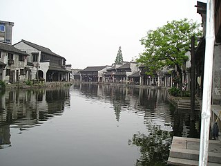
Nanxun District is a district in the prefecture-level city of Huzhou, Zhejiang province, China. Nanxun Town, an old town, is located in the district. It is one of the most well-preserved old towns in this region and is known for its cultural heritage. Other towns in the district include Shuanglin, Lianshi, Linghu, Shanlian, Qianjin and Shicong.

Lombardy, Ontario, is a community in the Township of Rideau Lakes, Leeds and Grenville County in Eastern Ontario. Its nearest communities are the town of Smiths Falls to the northeast, Rideau Ferry and Perth to the west, and Portland, Ontario to the southwest. The village of Lombardy is home to approximately 100 residents, with many more inhabiting the rural areas surrounding it. The only store in Lombardy is a vape shop, which was previously a restaurant.

The Tay Canal is the portion of the Tay River in the eastern Ontario region, providing a connection between the town of Perth and the Rideau Canal at Beveridge Bay on Lower Rideau Lake. The canal is 9.8 km (6.1 mi) in length and is operated today by Parks Canada as part of their Rideau Canal operations. At the entrance to the Tay Canal are two locks, Upper and Lower Beveridge Locks, which provide a total lift of 7.6 m (25 ft).

Wollombi is a small village in the Hunter Region of New South Wales, Australia. It is within the Cessnock City Council LGA, situated 29 kilometres (18 mi) southwest of Cessnock and 128 km (80 mi) north of Sydney. To the south is the village of Laguna, to the east, the village of Millfield and to the north, the village of Broke.
Kingston Mills, located approximately 7 kilometres (4.3 mi) north of downtown Kingston, Ontario, is the southernmost lockstation and one of 24 lockstations of the Rideau Canal system. Kingston Mills is a component of the Rideau Canal National Historic Site, and along with the rest of the Rideau Canal, is a World Heritage Site. The site is managed and operated by Parks Canada.
The history of Ottawa, capital of Canada, was shaped by events such as the construction of the Rideau Canal, the lumber industry, the choice of Ottawa as the location of Canada's capital, as well as American and European influences and interactions. By 1914, Ottawa's population had surpassed 100,000 and today it is the capital of a G7 country whose metropolitan population exceeds one million.

The Taemas Bridge is a two-lane road bridge that carries the Wee Jasper Road across the Murrumbidgee River, at the settlement of Taemas, near Wee Jasper in the Yass Valley Council local government area of New South Wales, Australia. The bridge crosses on the river just before it enters Lake Burrinjuck, which has been created by the Burrinjuck Dam. The bridge is a key part of the road between Yass and Wee Jasper, and from there, to Tumut. The bridge is located approximately 26 kilometres (16 mi) from Yass and 22 kilometres (14 mi) from Wee Jasper. The property is owned by Roads and Maritime Services, an agency of the Government of New South Wales. Under the Heritage Act, 1977 (NSW) s 170, the bridge was added to the New South Wales State agency heritage register on 18 August 2005.
The Rideau Ferry Yacht Club Conservation Area or Rideau Ferry Conservation Area was established along a 10 acres (4.0 ha) shoreline property on the Lower Rideau Lake. The former Rideau Ferry Yacht Club donated the property in 1976 to provide a public recreation area with access to the lake.