The Rideau Canal, also known unofficially as the Rideau Waterway, connects Canada's capital city of Ottawa, Ontario, to Lake Ontario and the Saint Lawrence River at Kingston, Ontario. It is 202 kilometres long. The name Rideau, French for "curtain", is derived from the curtain-like appearance of the Rideau River's twin waterfalls where they join the Ottawa River. The canal system uses sections of two rivers, the Rideau and the Cataraqui, as well as several lakes. Parks Canada operates the Rideau Canal.

The City of Kawartha Lakes is a unitary municipality in Central Ontario, Canada. It is a municipality legally structured as a single-tier city; however, Kawartha Lakes is the size of a typical Ontario county and is mostly rural. It is the second largest single-tier municipality in Ontario by land area.
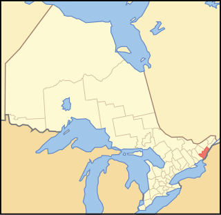
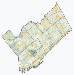
The United Counties of Leeds and Grenville, commonly known as Leeds Grenville, is a county in Ontario, Canada, in the Eastern Ontario subregion of Southern Ontario. It fronts on the Saint Lawrence River and the international boundary between Canada and the United States. The county seat is Brockville. The county was formed by the union of the historical counties of Leeds and Grenville in 1850.

North Grenville is a township in eastern Ontario, Canada, in the United Counties of Leeds and Grenville on the Rideau River. It is located just south of Ottawa in Canada's National Capital Region.

Westport is a village in Eastern Ontario, Canada. It lies at the west end of Upper Rideau Lake, at the head of the navigable Rideau Canal system, 100 km (62 mi) southwest of Ottawa.

Lanark County is a county located in the Canadian province of Ontario. Its county seat is Perth, which was first settled in 1816. Most European settlements of the county began in 1816, when Drummond, Beckwith and Bathurst townships were named and initially surveyed. The first farm north of the Rideau was cleared and settled somewhat earlier, in 1790. The county took its name from the town of Lanark in Scotland. Nearly all the townships were named after British public and military figures from the era of early settlement.

Drummond/North Elmsley is a township in eastern Ontario, Canada in Lanark County. It is situated on the north shore of the Rideau River between the town of Perth and the town of Smiths Falls. It is a predominantly rural municipality. The township offices are located in the hamlet of Port Elmsley.

The Municipality of Trent Lakes is a lower-tier township in the rural, mostly wooded northern section of Peterborough County, Ontario, Canada. The municipality has a primarily cottage and tourist industry based economy but has grown year round residency due to its commute distance to the Greater Toronto Area.
Leeds County is a historic county in the Canadian province of Ontario. The county was first surveyed in 1792 as one of the nineteen counties created by Sir John Graves Simcoe in preparation for the United Empire Loyalists to settle here. The county took its name from Francis Osborne, 5th Duke of Leeds; the "Leeds" of the Dukedom referred to Leeds in West Yorkshire, England and not for Leeds, Kent, England. In 1850, Leeds County merged with Grenville County to create the United Counties of Leeds and Grenville. This county was home to several townships as well as the city of Brockville.

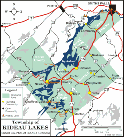
Portland is a police village and unincorporated place located in the municipal township of Rideau Lakes, United Counties of Leeds and Grenville in eastern Ontario, Canada. The community is on Ontario Highway 15 about 60 kilometres (37 mi) northeast of Ontario Highway 401 at Kingston by road, and is situated in geographic Bastard Township on the southeast side of Big Rideau Lake.

Burritts Rapids is a small village located on the Rideau River in eastern Ontario.
Benjamin Tett was an Ontario businessman and political figure. He represented Leeds South as a Conservative member of the 1st Parliament of Ontario.

Big Rideau Lake is a lake in the municipalities of Tay Valley and Drummond/North Elmsley, Lanark County and Rideau Lakes, United Counties of Leeds and Grenville in Eastern Ontario, Canada. The lake is on the border between the two counties, 72 kilometres (45 mi) to the southwest of Ottawa. It is 32 kilometres (20 mi) long and is 6 kilometres (3.7 mi) wide, is much narrower at its northeastern end than at its southwestern end, and is part of the Saint Lawrence River drainage basin. It is the largest lake on the Rideau Canal, which was designated a UNESCO world heritage site in 2007.
Rideau Ferry is a small community in Eastern Ontario, Canada, along the Rideau Waterway. Rideau Ferry straddles a narrow stretch of water joining the Big Rideau Lake to the Lower Rideau Lake. At Rideau Ferry, the south shore of the Rideau Waterway is located within the Township of Rideau Lakes in Leeds and Grenville County, and the north shore is located within the township of Drummond/North Elmsley in Lanark County.

Merrickville–Wolford is a village-status municipality in Eastern Ontario, Canada, located in the United Counties of Leeds and Grenville. It spans both shores of the Rideau River.

Leeds and the Thousand Islands is a township in the Canadian province of Ontario, located within the United Counties of Leeds and Grenville. The township is located along the Saint Lawrence River, and extends north into rural hamlets and villages. Formerly, this township was divided into three separate townships: Leeds, Landsdowne and Escott townships; these townships amalgamated to form the current township of Leeds and the Thousand Islands.
John Robertson Dargavel was an Ontario farmer, merchant and political figure. He represented Leeds in the Legislative Assembly of Ontario from 1905 to 1919 as a Conservative member.

Lake Opinicon is a lake in South Frontenac, Frontenac County and Rideau Lakes, United Counties of Leeds and Grenville in Eastern Ontario, Canada. This shallow lake was formed when Colonel John By built the Rideau Canal. It also is part of the Great Lakes Basin.

Upper Rideau Lake is located in the municipality of Rideau Lakes, United Counties of Leeds and Grenville in Eastern Ontario, Canada. It is in the Saint Lawrence River Drainage Basin, and geographically the highest lake on the Rideau Canal System.
King's Highway 42, commonly referred to as Highway 42, was a provincially maintained highway in the Canadian province of Ontario. The 52.8-kilometre (32.8 mi)-long route connected Highway 29 at Forthton with the town of Westport, intersecting Highway 15 en route. Highway 42 was assumed in 1935, and aside from paving the partially gravelled road, generally remained unchanged throughout its existence. In 1997, it was decommissioned and transferred to the United Counties of Leeds and Grenville, subsequently being redesignated as Leeds and Grenville County Road 42.