The Grand Canyon is a steep-sided canyon carved by the Colorado River in Arizona, United States. The Grand Canyon is 277 miles (446 km) long, up to 18 miles (29 km) wide and attains a depth of over a mile.

Scouting in Kentucky has a long history, from the 1910s to the present day, serving thousands of youth in programs that suit the environment in which they live. Kentucky has a very early Scouting heritage, as the home state of Daniel Carter Beard.

The Pennyroyal Plateau is a large area of Kentucky that features rolling hills, caves, and karst topography in general. It is named for a wild mint that grows in the area. It is also called the "Mississippian Plateau," for the Mississippian geologic age in which it was formed.
Fort Campbell is a United States Army installation located astride the Kentucky-Tennessee border between Hopkinsville, Kentucky and Clarksville, Tennessee. Fort Campbell is home to the 101st Airborne Division and the 160th Special Operations Aviation Regiment.
The Nashville Basin, also known as the Central Basin, is a term often used to describe the area surrounding Nashville, Tennessee. The Central Basin was caused by an uplifting which produced a dome known as the Nashville Dome. The Nashville Dome is evidenced by the underlying rock strata that all dip downwards away from Nashville. The uplifting of the Nashville Dome fractured overlying strata, making it more easily eroded and thus the "dome" resulted in a "basin". Uplifted strata in the center of a geological dome have higher potential erosive energy than the surrounding strata, because they are physically higher. Erosion thus acts on the uplifted area at a greater rate than on the surrounding flat-lying area, creating a low area, i.e. a basin. This area is more correctly referred to as the "Central Dome" of Tennessee.
The Highland Rim is a geographic term for the area in Tennessee surrounding the Central Basin. Nashville is largely surrounded by higher terrain in all directions.

Sea Rim State Park is a 4,141-acre (1,676 ha) state park in southeast Texas. The park is located on the Gulf of Mexico in southern Jefferson County, south of Port Arthur and just west of Sabine Pass. The park was closed for several years due to extensive damage from Hurricanes Rita (2005) and Ike (2008). The park has recently re-opened but currently has limited resources.

Cloudland Canyon State Park is a 3,485 acres (14.10 km2) Georgia state park located near Trenton and Cooper Heights on the western edge of Lookout Mountain. One of the largest and most scenic parks in Georgia, it contains rugged geology, and offers visitors a range of vistas across the deep gorge cut through the mountain by Sitton Gulch Creek, where the elevation varies from 800 to over 1,800 feet. Views of the canyon can be seen from the picnic area parking lot, in addition to additional views located along the rim trail. At the bottom of the gorge, two waterfalls cascade across layers of sandstone and shale, ending in small pools below.

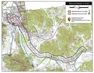
The Battle of Barbourville was one of the early engagements of the American Civil War. It took place on September 19, 1861, in Knox County, Kentucky during the campaign known as the Kentucky Confederate Offensive. The battle is considered the first Confederate victory in the commonwealth, and threw a scare into Federal commanders, who rushed troops to central Kentucky to try to repel the invasion, which was finally stopped at the Battle of Camp Wildcat in October.

Kentucky Camp is a ghost town and former mining camp along the Arizona Trail in Pima County, Arizona, United States, near the community of Sonoita. The Kentucky Camp Historic District is listed on the National Register of Historic Places and has been since 1995. As it is located within Coronado National Forest, the United States Forest Service is responsible for the upkeep of the remaining buildings within the Kentucky Camp Historic District.

The Lincoln Heritage Council (LHC) is a local council of the Boy Scouts of America serving 64 counties in four states: Kentucky, Indiana, Illinois, and Tennessee.

Camp Joe Holt was a Union base during the American Civil War in Jeffersonville, Indiana, across the Ohio River from Louisville, Kentucky, on land that is now part of Clarksville, Indiana, near the Big Eddy. It was a major staging area for troops in the Western Theatre of the War, in preparation for invading the Confederate States of America. Its establishment was the first major step performed by Kentucky Unionists to keep Kentucky from seceding to the Confederacy.

Camp Nelson National Monument, formerly Camp Nelson Civil War Heritage Park, is a 525-acre (2.12 km2) national monument, historical museum and park located in southern Jessamine County, Kentucky, United States, 20 miles (32 km) south of Lexington, Kentucky. The American Civil War era camp was established in 1863 as a depot for the Union Army during the Civil War. It became a recruiting ground for new soldiers from Eastern Tennessee and escaped slaves, many of whom trained to be soldiers. On October 26, 2018, President Donald Trump proclaimed the site as Camp Nelson National Monument, the 418th unit of the National Park Service (NPS) system.
Pine Mountain State Scenic Trail is a 120 mi (193 km) trail under development in the U.S. state of Kentucky. Once completed, the trail will wind along Pine Mountain Ridge from the Breaks Interstate Park to Cumberland Gap National Historical Park. The park itself will cover a 1,000 acres (4.0 km2) band along Pine Mountain.

North Korea made its Paralympic Games début at the 2012 Summer Paralympics in London, sending a single wildcard representative to compete in swimming.

Wheel Rim is an unincorporated community in Morgan County, Kentucky, United States. It was also known as Burg. The community was named for a wagon wheel rim noted to be hanging in the trees.

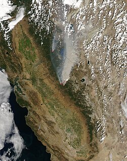
The Rim Fire was a massive wildfire that started in a remote canyon in Stanislaus National Forest in California. This portion of the central Sierra Nevada spans Tuolumne and Mariposa counties. The fire started on August 17, 2013 during the 2013 California wildfire season and grew to be the third-largest wildfire in California's history, having burned 257,314 acres. As of 2018, the Rim Fire was California's fifth-largest modern wildfire. The Rim Fire is also the largest wildfire on record in the Sierra Nevada mountain range. The Rim Fire was fully contained on Thursday, October 24, 2013 after a nine-week firefighting battle. Due to a lack of winter rains, some logs smoldered in the interior portion of the fire throughout the winter. More than a year passed before it was declared out on November 4, 2014.

Tamborine is a town in the Scenic Rim Region and a locality split between the Scenic Rim Region and the City of Logan in Queensland, Australia. In the 2011 census, Tamborine had a population of 3,464.

The Battle of Camp Wildcat was one of the early engagements of the American Civil War. It occurred October 21, 1861, in northern Laurel County, Kentucky during the campaign known as the Kentucky Confederate Offensive or Operations in Eastern Kentucky (1861). The battle is considered one of the first Union victories of the Civil War, and marked the second engagement of troops in the Commonwealth of Kentucky.

Not to be confused with Amadou Diallo.


