County Waterford is a county in Ireland. It is in the province of Munster and is part of the Southern Region. It is named after the city of Waterford. Waterford City and County Council is the local authority for the county. The population of the county at large, including the city, was 127,363 according to the 2022 census. The county is based on the historic Gaelic territory of the Déise. There is an Irish-speaking area, Gaeltacht na nDéise, in the southwest of the county.

Waterford is a city in County Waterford in the south-east of Ireland. It is located within the province of Munster. The city is situated at the head of Waterford Harbour. It is the oldest and the fifth most populous city in the Republic of Ireland. It is the ninth most populous settlement on the island of Ireland. According to the 2022 census, 60,079 people live in the city, with a wider metropolitan population of 82,963.

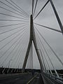
A cable-stayed bridge has one or more towers, from which cables support the bridge deck. A distinctive feature are the cables or stays, which run directly from the tower to the deck, normally forming a fan-like pattern or a series of parallel lines. This is in contrast to the modern suspension bridge, where the cables supporting the deck are suspended vertically from the main cable, anchored at both ends of the bridge and running between the towers. The cable-stayed bridge is optimal for spans longer than cantilever bridges and shorter than suspension bridges. This is the range within which cantilever bridges would rapidly grow heavier, and suspension bridge cabling would be more costly.

The N11 road is a national primary road in Ireland, running for 129 km (80 mi) along the east side of Ireland from Dublin to Wexford. It passes close to Bray, Greystones, Wicklow, Arklow, Gorey, and Enniscorthy. Beyond Wexford, the route continues to Rosslare as the N25. The road forms part of European route E01. As of July 2019 the N11/M11 is of dual carriageway or motorway standard from Dublin as far as Oilgate in County Wexford.
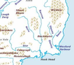
The Three Sisters are three rivers in Ireland: the River Barrow, the River Nore and the River Suir. The Suir and Nore rise in the same mountainous area in County Tipperary, near the Devil's Bit, while the Barrow rises in the Slieve Bloom Mountains in County Laois. The Nore flows into the Barrow about 17 km before the Suir and Barrow join to form an estuary called Waterford Harbour east of the city of Waterford. The rivers fan out to drain a large portion of the southern part of the island, including Counties Tipperary, Carlow, Kilkenny, Wexford and Waterford, among others.

The Mary McAleese Boyne Valley Bridge is a cable-stayed bridge in County Meath, and County Louth, Ireland. It spans the Boyne River 3 kilometres (1.9 mi) west of Drogheda on the county boundary between County Meath and County Louth and is part of the M1 Northern Motorway. When it opened in June 2003, it was the longest cable-stayed bridge in Ireland until 19 October 2009, when the River Suir Bridge opened on the N25.
The N9 road is a national primary road in Ireland running from Junction 11 on the M7, located near Kilcullen, County Kildare, to Waterford city. The route connects Dublin and Waterford. The section of the route from junction 11 on the M7 at Kilcullen to the intersection with the N24 road outside Waterford is motorway standard since 2010 and is designated as the M9 motorway. In line with Irish practice, all sections previously designated N9 were renumbered at that time. Only a short (550-metre) section of the route is still designated as N9 between the Quarry roundabout junction with the N24 and the N25 Grannagh Roundabout junction. This section is dual carriageway.
The N25 road is a national primary road in Ireland, forming the route from Cork to Rosslare Europort via Waterford City. The road is part of the E30 European route and a short section is also part of the E01 European route. It forms part of the proposed Atlantic Corridor route.

An extradosed bridge employs a structure that combines the main elements of both a prestressed box girder bridge and a cable-stayed bridge. The name comes from the word extrados, the exterior or upper curve of an arch, and refers to how the "stay cables" on an extradosed bridge are not considered as such in the design, but are instead treated as external prestressing tendons deviating upward from the deck. In this concept, they remain part of the main bridge superstructure.

The N29 road is a national primary road in Ireland. It connects the Port of Waterford at Belview, County Kilkenny to Waterford City via the N25. The road and port are located on the north bank of the River Suir.

The N30 road is a national primary road in Ireland. It connects the N25 road and M11 motorway, providing a link running east-northeast through County Wexford, between New Ross and Enniscorthy. This provides for a more direct national route between the two towns, as the N25 and N11 both run to Wexford town, eastwards from New Ross and southwards from Enniscorthy respectively.
John's River or St. John's River is a small river that snakes its way through Waterford city before joining the River Suir at Adelphi Quay, Ireland.

The R710 road is a regional road in Ireland. Located in the south of Ireland at Waterford, it forms the Outer Ring Road around the south of the city. As of December 2006 it commences on the Old Kilmeaden Road at Knockhouse Lower, west of Waterford City and ends at a junction with the R683 on the Dunmore Road in the south-east of the city.

Kilmeadan or Kilmeaden is a village in County Waterford, Ireland. It is 10 km (6 mi) west of the centre of Waterford city on the R680 road.
The Tianxingzhou Yangtze River Bridge is a combined road and rail bridge across the Yangtze River in the city of Wuhan, the capital of the Hubei Province of China.
This article deals with transport in Waterford city in Ireland. The city is connected by road, rail, bus, air and sea. There are currently proposals for a bus rapid transit system, consisting of bus trams, or streetcars, to be used in future.

The N40 road is a national primary road in Cork City, Ireland. It is partial ring road skirting the southern suburbs of the city, from the N22 west of Ballincollig, via the Jack Lynch Tunnel under the River Lee, to the Dunkettle Interchange where it meets the N25 and N8/M8. The present N40 designation was created on 23 February 2012 via statutory instrument from parts of both the N22 and N25 built from 1990 onwards. The N40 serves as both a commuter route and a bypass of the city centre for traffic between parts southwest and east. The National Transport Strategy envisages building a "Cork North Ring Road" to complete the circuit in the 2030s.

The Rose Fitzgerald Kennedy Bridge is an extradosed bridge over the River Barrow in Ireland. It was built as part of the N25 New Ross Bypass, and was officially opened on 29 January 2020 by Taoiseach Leo Varadkar and opened to traffic on 30 January 2020, becoming Ireland's longest bridge.