
Odessa is a town in New Castle County, Delaware, United States. The population was 364 at the 2010 census. Founded as Cantwell's Bridge in the 18th century, the name was changed in the 19th century, after the Ukrainian port city of the same name. Today a significant part of the town is a historic district list on the National Register of Historic Places.

Williston is a city in Levy County, Florida, United States. It is part of the Nature Coast. As of the 2020 census, it had a population of 2,976, up from 2,768 at the 2010 census. It is part of the Gainesville, Florida Metropolitan Statistical Area.

Tiffin is a city in Johnson County, Iowa, United States. It is part of the Iowa City, Iowa Metropolitan Statistical Area. The population was 4,512 at the time of the 2020 census. F. W. Kent County Park is located just to the west of Tiffin, and is a popular site for outdoor recreation in Johnson County, being noted for its lake, camping facilities, resident whitetail deer herd and wild turkeys, and its cross-country ski trails through rolling acres of oak and hickory forest.

Towanda is a borough in, and the county seat of, Bradford County in the U.S. state of Pennsylvania. It is part of Northeastern Pennsylvania and is located 66 miles (106 km) northwest of Wilkes-Barre, on the Susquehanna River. The name means "burial ground" in the Algonquian language. As of the 2020 census, the population of Towanda was 2,833.

Blossom is a city in Lamar County, Texas, United States. The population was 1,402 at the 2020 census.

Irvington is a town on the Rappahannock River in Lancaster County, Virginia, United States. The population was 474 at the 2020 census. Located on a peninsula known as the Northern Neck, it has been designated a historic district.

The Snoqualmie River is a 45-mile (72 km) long river in King County and Snohomish County in the U.S. state of Washington. The river's three main tributaries are the North, Middle, and South Forks, which drain the west side of the Cascade Mountains near the town of North Bend and join near the town of Snoqualmie just above the Snoqualmie Falls. After the falls the river flows north through rich farmland and the towns of Fall City, Carnation, and Duvall before meeting the Skykomish River to form the Snohomish River near Monroe. The Snohomish River empties into Puget Sound at Everett. Other tributaries of the Snoqualmie River include the Taylor River and the Pratt River, both of which enter the Middle Fork, the Tolt River, which joins at Carnation, and the Raging River at Fall City.

The California State Senate is the upper house of the California State Legislature, the lower house being the California State Assembly. The state senate convenes, along with the state assembly, at the California State Capitol in Sacramento.
Del Paso Heights is a neighborhood within the city of Sacramento in Sacramento County, California, United States. The generally recognized borders of Del Paso Heights consist of the Beltline Freeway Interstate 80 on the north, Norwood Avenue on the west, Arcade Creek on the south, and Roseville Road on the east. Del Paso Heights is located in Area 4 of Sacramento which is defined as the city north of the American River.
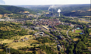
La Robla is a municipality located in the province of León, Castile and León, Spain. According to the 2020 census (INE), the municipality has a population of 3,752 inhabitants.

Kanwaka Township is a township in Douglas County, Kansas, USA. As of the 2000 census, its population was 1,317. The name is a portmanteau of the Kansas River and Wakarusa River.
Conoy Creek is an 11.2-mile-long (18.0 km) tributary of the Susquehanna River in Lancaster County, Pennsylvania, in the United States.
Bresničić is a village in the municipality of Prokuplje, Serbia. According to the 2002 census, the village has a population of 261 people. The village is approximately 20 km from Prokuplje, Serbia, the nearest larger city.

Studa is an unincorporated community in West Middletown, Washington County, Pennsylvania, United States.
Furnace is an unincorporated community in Page County, in the U.S. state of Virginia.
Bačvište is a village in the municipality of Vladičin Han, Serbia. According to the 2002 census, the village has a population of 65 people.
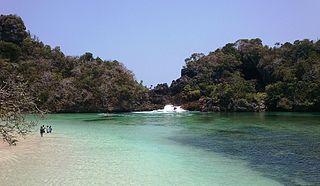
Sempu is an island located 800 meters from the southern coast of the province of East Java in Indonesia, about 70 km south of the city of Malang. The island comprises the administrative village of Tambakrejo within the Sumbermanjing District of Malang Regency, with a population at the 2020 Census of 7,193. It is 3.9 km long and 3.6 km wide and covers a land area of 8.77 km2. Its topography is largely rolling hills whose altitude ranges from 50 to 100 meters above sea level. The coastline consists mainly of limestone cliffs characteristics of the façade of the island of Java in the Indian Ocean.
Las Delicias or Delicias is a town in the Venezuelan Andean state of Táchira. The town is the shire town of the Rafael Urdaneta municipality and, according to the 2001 Venezuelan census, has a population of 6,224. It is located on the Colombian border, 4 kilometres (2.5 mi) from the Colombian town of Ragonvalia.
Claysville is an unincorporated community in Boone County, in the U.S. state of Missouri. It is the southernmost settlement in Boone County. Claysville is near the Missouri River.
Tremont Township was a historical subdivision of Solano County, California. It comprised the portions of Solano County opposite Putah Creek from Davisville, in the northeastern part of the county. Tremont Township was defined by the Solano County Board of Supervisors on August 11, 1855, and appears on an 1890 map of Solano County. Civil townships are no longer legally recognized in California, and the Tremont name is no longer widely used; however, a Tremont Road and Tremont Cemetery remain in the historical township.
