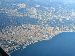
Barcelona is a province of eastern Spain, in the center of the autonomous community of Catalonia. The province is bordered by the provinces of Tarragona, Lleida, and Girona, and by the Mediterranean Sea. Its area is 7,726 km2 (2,983 sq mi). 5,743,402 people live in the province, of whom about 29% (1,664,182) live within the administrative limits of the city of Barcelona, which itself is contained in the Barcelona metropolitan area.
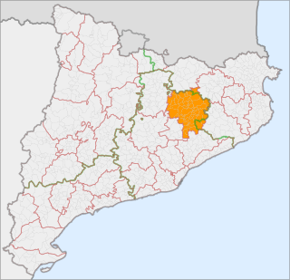
Osona is a comarca situated in Catalonia, Northeast Spain. Its capital is Vic. Its population in 2001 was 129,543. Osona covers roughly the same area as the historic Catalan county of Osona. The name Osona comes from Ausetans, a group of Iberian people who had their capital in Ausa ; the Romans called the area Ausone or Ausona. While most of the comarca is within the province of Barcelona, the municipalities of Espinelves, Vidrà and Viladrau form part of the province of Girona.

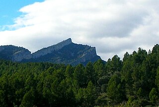
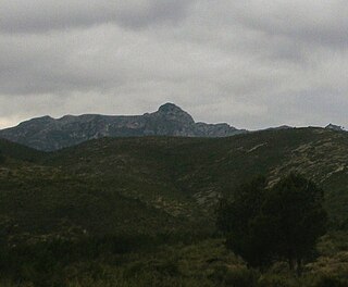
Matagalls is one of the highest mountains of the Montseny Massif, Catalonia, Spain. It has an elevation of 1,697.9 metres above sea level.

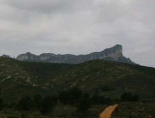
Sant Miquel de Solterra or Sant Miquel de les Formigues is the highest mountain of the Guilleries Massif, Catalonia, Spain. It has an elevation of 1,201.9 metres above sea level.
Picorandan is a mountain of Catalonia, Spain. It is part of the Catalan Pre-Coastal Range. Its maximum elevation is 991 metres above sea level.

Creu de Santos or Xàquera is the highest mountain of the Serra de Cardó range, Catalonia, Spain. The Serra de Cardó is part of the Massís de Cardó, Catalan Pre-Coastal Range. This mountain has an elevation of 941 metres above sea level.

Tossal Gros de Miramar, or simply Tossal Gros, is a mountain of the Catalan Pre-Coastal Range, Catalonia, Spain. It has an elevation of 866.6 metres above sea level.

Tossal Gros de Vallbona is a mountain of the Catalan Central Depression, Catalonia, Spain. It has an elevation of 802 metres above sea level.
Puig de la Talaia is a mountain located in the El Montmell municipal term, in the Baix Penedès comarca, Catalonia, Spain. It has an elevation of 801 metres above sea level and is part of the Catalan Pre-Coastal Range.

Serra de Montsant is a mountain chain in Catalonia, Spain. The main populated area in the range is La Morera de Montsant.

The Catalan Transversal Range is a system of minor mountain ranges at the eastern end of the Pre-Pyrenees, between the Osona and Garrotxa comarques. The existence of the Catalan Transversal Range has made communications in the northern areas of Catalonia difficult in the past, especially between Northeastern Catalonia and Western Catalonia, a problem that has been partly solved with the development of the Eix Transversal.
The Catalan Mediterranean System, also known as Mediterranean System, Transversal Ibero-Pyrenaean System, and Catalanid System, is a wide coastal geographical region in Catalonia. It is made up of a double system of coastal mountain chains: The Catalan Coastal Range and the Catalan Pre-Coastal Range, as well as the Catalan Coastal Depression and other coastal and pre-coastal plains located among those mountain ranges.

The Coll de Balaguer is a mountain pass in Catalonia, Spain. It is located at the point where the Catalan Pre-Coastal Range reaches the sea, in L'Almadrava, within the Vandellòs i l'Hospitalet de l'Infant municipality, Baix Camp.
Serra de Paüls is a mountain range in the northern side of the Ports de Tortosa-Beseit, Catalonia, Spain. The highest summit, Punta de l'Aigua has an elevation of 1,091.6 metres above sea level.
Serra de la Llena, also known as Serra la Llena, is a mountain chain straddling the municipal terms of Vilanova de Prades, La Pobla de Cérvoles (Garrigues) and Ulldemolins (Priorat), in Catalonia, Spain. These mountains have characteristic large and rounded rocky outcrops.
Prades Mountains, also known as Muntanyes de Prades, is a large calcareous mountain massif straddling the comarcas of Alt Camp, Baix Camp, Conca de Barberà, Garrigues and Priorat, in Catalonia, Spain. They are a Site of Community Importance.
Morral de Cabrafeixet is one of the highest mountains of the Cardó Massif, Catalan Pre-Coastal Range, Catalonia, Spain. Its NW side has an impressive escarpment visible from Highway N-340 approaching El Perelló from the north. This mountain has an elevation of 753 metres above sea level.
Buinaca or Punta de la Buinaca, also spelt Boinaca, is one of the highest mountains of the Cardó Massif, Catalan Pre-Coastal Range, Catalonia, Spain. This mountain has an elevation of 764 metres above sea level.

Serra de Llaberia is a mountain chain in Catalonia, Spain located between the Prades and the Tivissa-Vandellòs Mountains.

Mola de Colldejou is a mountain chain in Catalonia, Spain located north of the Serra de Llaberia in the Catalan Pre-Coastal Range. The highest point is 921.8 m above sea level.

